


You must be logged in to view this content.
Bertha Is Expected To Come Ashore Along The Texas Coast As Barely A Tropical Storm During This Afternoon & This Evening
You must be logged in to view this content.
Bertha Remains A Tropical Storm & Is Expected To Bring Limited Impacts To The Northern Gulf Coast Today; Bertha Then Looks To Head For The Middle Texas Coast As We Get Into Thursday
You must be logged in to view this content.
Bertha Seems To Be Strengthening Today & May Actually Try To Make A Run At Hurricane Intensity Later Today Or Tonight; Weakening Is Then Expected Starting On Wednesday As Bertha Moves Near The Northern Gulf Coast
You must be logged in to view this content.
Tropical Depression #2 Is Expected To Become Tropical Storm Bertha Sometime Later Today Or Tonight & Will Then Affect The Northern Gulf Coast Over The Next Couple Of Days Or So
Tropical Depression #2: Tropical Depression 2 seems to be becoming a bit better organized today. Satellite imagery and other weather data seems to suggest that there is an increased amount of banding near the center of circulation, which is also better defined. That being said, TD 2 is being affected by northeasterly wind shear of up to 20-30 knots and dry air – both of which may end up limiting the amount of strengthening this system is able to accomplish.
Given that there is more centralized convection and increased banding occurring with TD 2, I do think that it is extremely likely that this system will be upgraded to Tropical Storm Bertha as soon as later today or tonight.
A look at the latest ensemble model guidance from the GFS and European models reveals that they have shifted towards a more northerly track taking this system into the central Gulf Coast near the Mississippi Delta by about Wednesday night or Thursday.
Other guidance such as the European AIFS and the Google DeepMind ensemble model suggests that a slightly further south track is possible, which would lead to this system skirting the Louisiana coast by about Thursday and heading towards the upper Texas coast, weakening into a depression as it does so.
Here Are My Latest Thoughts: I do think that TD 2 will likely battle northeasterly wind shear and dry air throughout the rest of its journey. Because of this, rapid strengthening is highly unlikely & in fact, I think the idea of this system becoming a hurricane is now off of the table.
More likely is that TD 2 will probably become Tropical Storm Bertha as soon as later today or tonight & then strengthen a little more over the next couple of days. This means that I think that this system will probably peak at a moderately strong tropical storm as it tracks westward just offshore of the northern Gulf Coast by midweek.
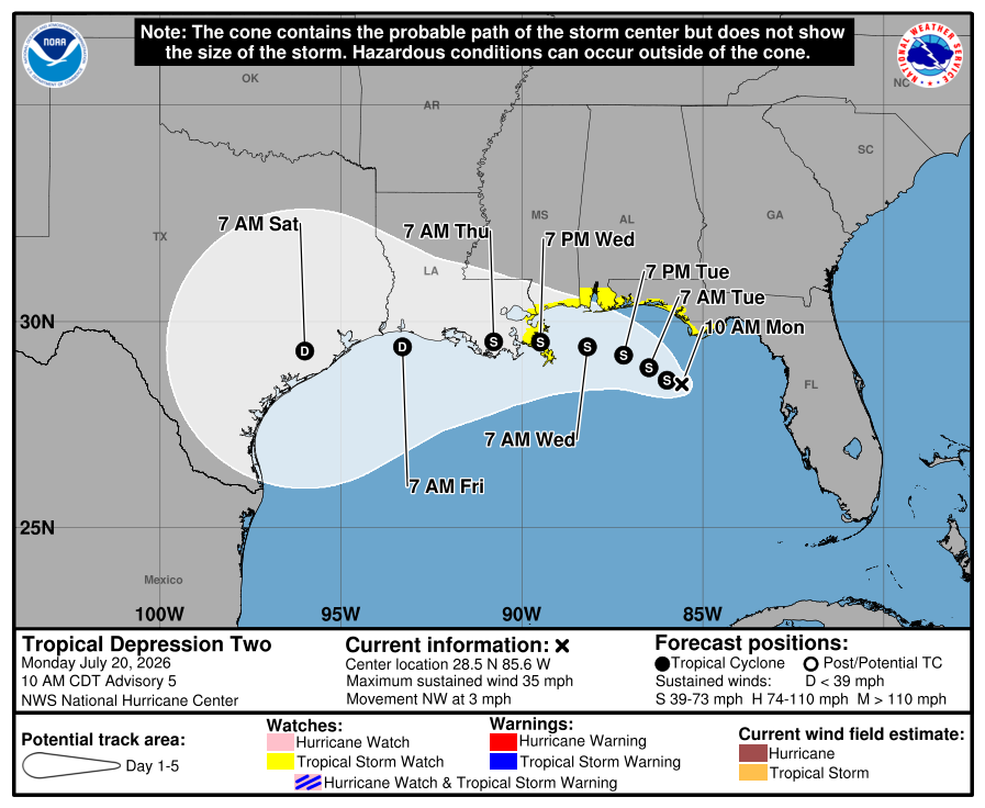
As for the possible track of TD 2 – It appears that a high pressure ridge nosing southward from the central United States will cause this system to turn due west by late Tuesday or Wednesday. This could cause this system to either make landfall in the Mississippi Delta region by Wednesday night or ride along the coast of southern Louisiana from Wednesday night to Friday morning before it comes ashore along the upper Texas coast sometime later Friday. In both cases, this system will probably peak at a moderately strong tropical storm & very likely will not become a hurricane.
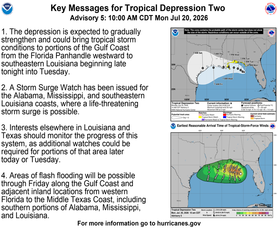
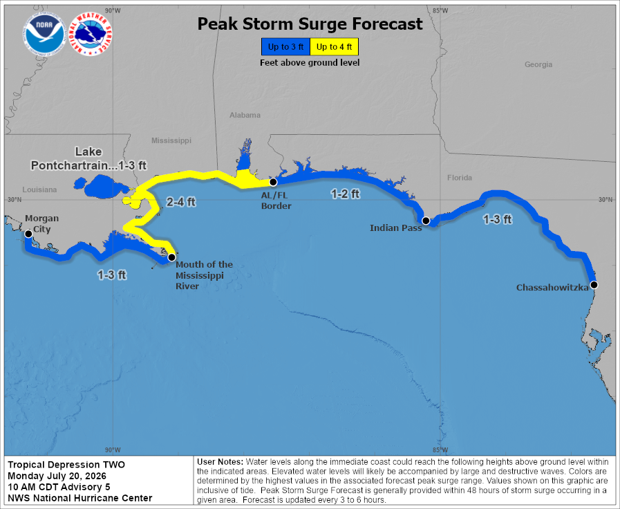
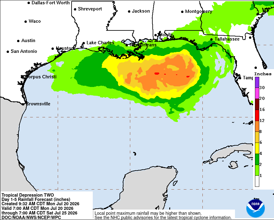
The main hazard from TD2/Bertha-To-Be likely will be locally heavy rainfall & dangerous rip currents along parts of the northern Gulf Coast this week. The locally heavy rain looks to mainly affect the Florida Panhandle today through Tuesday & then mainly affect southern and southeastern Louisiana during Wednesday and Thursday.
At this point, I am not expecting a widespread flood threat from TD 2/Bertha-to-be, but instead I think that some localized flooding is possible during Wednesday and Thursday across southern Louisiana and possibly across southeast Texas.
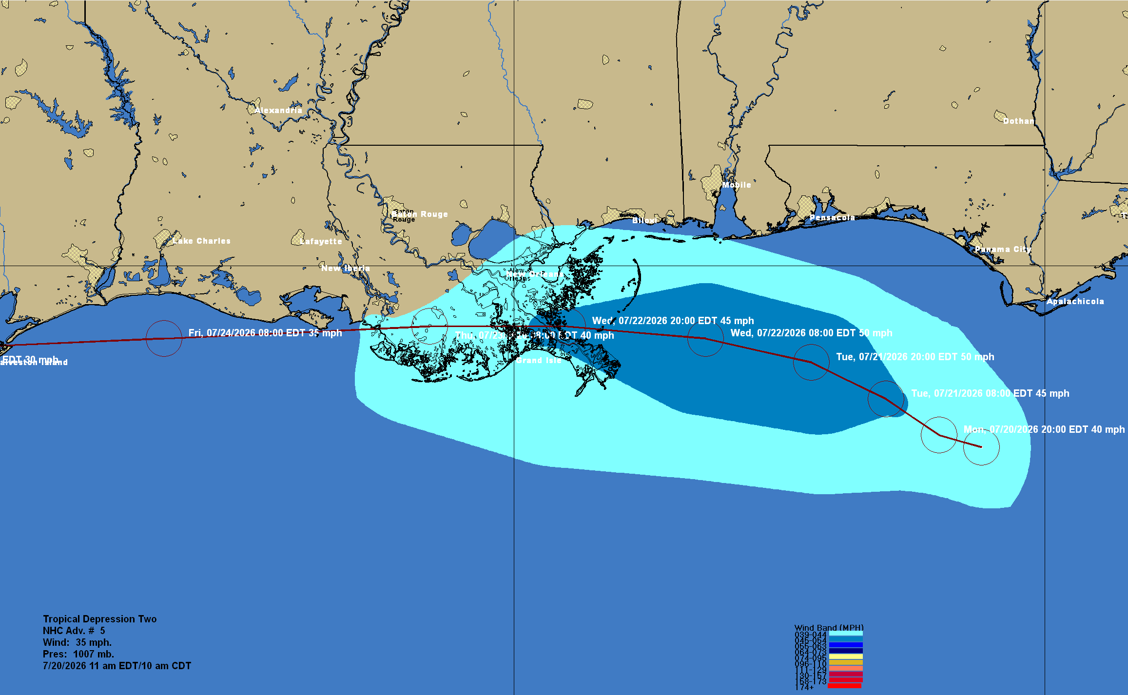
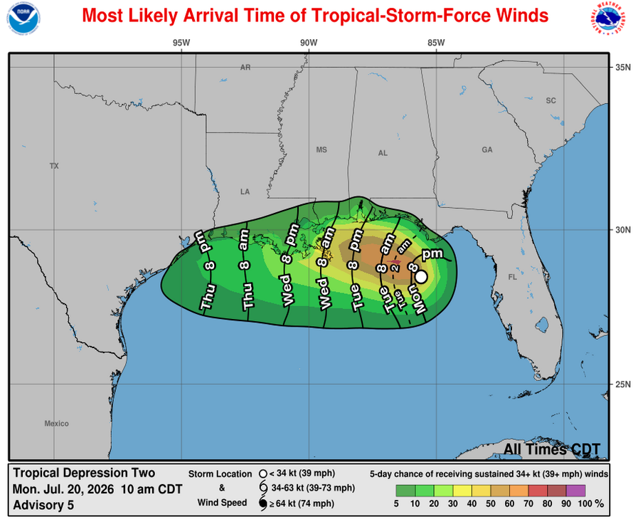
Any tropical storm force winds looks to be confined to southern and southeastern Louisiana during Wednesday and Thursday with wind gusts of up to 40-50 mph possible, especially along the immediate coast.
Forecast Impacts:
Wind:
Storm Surge:
Rainfall Amounts:
Tropical Depression #2 Forms Over The Northeastern Gulf & Will Become Tropical Storm Bertha Over The Next Day Or So As It Affects The Northern Gulf Coast & Eventually The Western Gulf Coast From The Florida Panhandle To Coastal Louisiana & The Upper Texas Coast
You must be logged in to view this content.
Invest 91-L Located Over The Eastern Gulf May Develop Into A Tropical Depression Or Tropical Storm Bertha Over The Next Few Days Or So As It Heads Westward Across The Northern Gulf
You must be logged in to view this content.
There Remains A Small Chance For Tropical Development In The Northeast Gulf Sometime This Weekend Or Early Next Week
You must be logged in to view this content.
There Is A Small Chance For Tropical Development In The Northeast Gulf This Weekend Or Early Next Week
You must be logged in to view this content.
Tropical Development Is A Possibility This Weekend Or Early Next Week In The Eastern & Northeastern Gulf
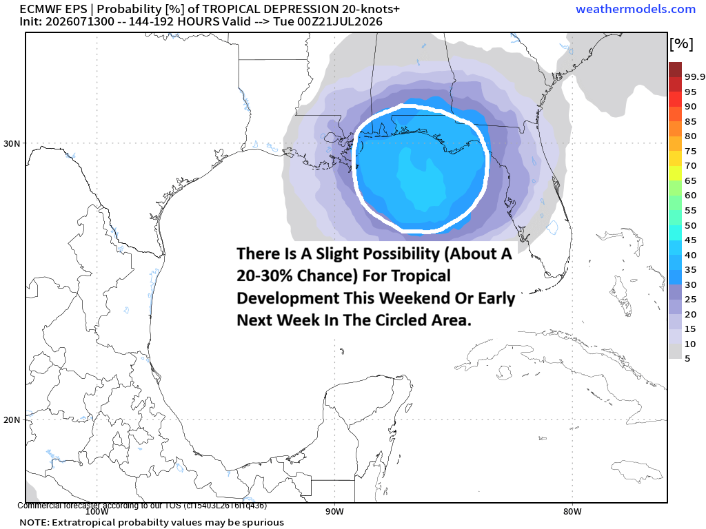
There remains the possibility of tropical development sometime during this weekend or early next week over the eastern and northeastern Gulf. That being said, as of right now, the chances for tropical development are very low.
A frontal boundary is expected to push southward into the eastern Gulf by this weekend. There then is the possibility that a low pressure system could form near the tail end of this front over the eastern or northeastern Gulf during the weekend. Should this occur, it could lead to the development of a tropical system that forms this weekend into early next week somewhere over the eastern or northeastern Gulf.
A look at the model guidance reveals that the European AIFS and its ensemble members remain the most aggressive with showing tropical development. It should be pointed out that the European AIFS model has been over forecasting tropical development lately and this is something that should be considered when trying to determine whether tropical development might occur.
As for the other model guidance, the most recent run of the GFS model shows no development at all. The Canadian model, interestingly, shows the possible development occurring near the coast of the Carolinas during the first half of next week. Last night’s run of the European model does hint at development occurring over the northeastern Gulf by early next week. The newest run of the ICON model now also shows tropical development occurring in the northeastern Gulf this weekend with the system heading for the Florida Panhandle during early next week.
Here Are My Thoughts: I definitely think that tropical development in the eastern and northeastern Gulf is a possibility this weekend or early next week. As of right now, I think the chances of tropical development are around 20 to 30 percent or so.
The setup for tropical development in the eastern and northeastern Gulf this weekend or early next week is one that’s kind of classic. This setup is expected to include a low pressure system forming near the tail end of an old front. This low pressure system would also form under an upper-level high pressure system located to the north & overall the environmental conditions look at least marginal for development. That being said, there are a couple of negative environmental conditions that could put a stop to any sort of development. This includes some northerly wind shear and dry continental air that could affect whatever tries to form.
Again, my thinking is that the chances for tropical development are very low this weekend into early next week across the eastern and northeastern Gulf. That being said, it is something that I’ll be keeping a close eye on throughout this week.
- « Previous Page
- 1
- 2
- 3
- 4
- 5
- 6
- …
- 25
- Next Page »