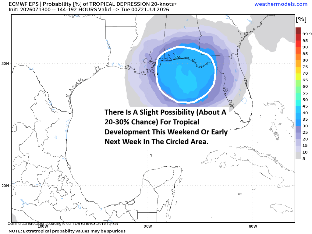
CrownWeather-final logo
CrownWeather-final-logo-mobile
icon burger
  • Pricing
  • Who is Crown Weather
  • CWS Support Services
  • Log In

Crown Weather
Discussions

All Is Quiet Across The Atlantic With No Tropical Development Expected This Week Through Probably At Least Next Week

Monday, June 22, 2026 2:20 pm by Rob Lightbown

All is now quiet across the Atlantic, Caribbean and the Gulf & no tropical development is expected throughout this week. In fact, tropical development looks unlikely right through next week, if not longer.

The Atlantic Basin is being heavily impacted by a large amount of Saharan dust. This, in combination with strengthening El Nino conditions will keep the Atlantic Basin shut down for at least the next couple of weeks, if not longer. Large Saharan dust outbreaks like this are common this time of year & usually peaks during late June and early July before the amount of dust begins to wane towards August.

Another factor that will prevent tropical development for the next 1 to 2 weeks will be strong amounts of wind shear that’ll be present across much of the Atlantic, Caribbean and the Gulf.

Bottom Line Is That the Atlantic, Caribbean and the Gulf should be very quiet in terms of tropical development chances through the end of this month, at least. In fact, the longer range ensemble guidance seems to be pointing towards things remaining quiet through at least mid-July.

Filed Under: CWS Weather Discussions

Area Of Disturbed Weather Over The Western Gulf May Need To Be Watched When It Moves Into The Northwestern Gulf On Tuesday Into Wednesday

Saturday, June 13, 2026 2:11 pm by Rob Lightbown

You must be logged in to view this content.

Filed Under: CWS Weather Discussions

Area Of Disturbed Weather Over The Bay Of Campeche May Need To Be Watched When It Reaches The Northern Gulf Early Next Week

Friday, June 12, 2026 12:02 pm by Rob Lightbown

You must be logged in to view this content.

Filed Under: CWS Weather Discussions

50 Percent Off A Lifetime Subscription To Crown Weather PLUS From Now Until Monday Night, June 15th

Thursday, June 11, 2026 12:04 pm by Rob Lightbown

We have decided to run a LIFETIME subscription special that’ll go from now through this weekend & end on Monday night, June 22.

From now until 11:59 pm Eastern Time on Monday night, June 22nd, you can go ahead and convert your current subscription to a lifetime subscription at half the normal cost. This is ideal for those of you that have been using our products for years now as you will never have to renew again!!

Our special price for a lifetime subscription to Crown Weather PLUS is $300 (normal price is $600). For the price of a 3 year subscription, you can be ensured that you will be subscribed indefinitely.


Get A LIFETIME Subscription Special At Half The Nornmal Cost:

Pay $300 Using PayPal:

Pay $300 Using A Credit Card:


Filed Under: CWS Weather Discussions

The Bay Of Campeche Will Be An Area To Watch Closely This Weekend, However, Tropical Development Looks Unlikely

Wednesday, June 10, 2026 1:05 pm by Rob Lightbown

It appears that the energy and moisture from Tropical Storm Cristina, which is currently located in the eastern Pacific to the south of Guatemala and El Salvador, will cross Central America on Thursday into Friday. This energy and moisture will then push into the Bay of Campeche by late Friday and then head northwestward towards the coast of eastern and northeastern Mexico during this weekend. While it looks likely that a low pressure system and area of disturbed weather will be located in the Bay of Campeche this weekend, it seems unlikely that it’ll significantly develop due to unfavorable environmental conditions.

A look at the weather forecast guidance reveals that they do seem to point towards there being a window of opportunity for tropical development between Friday night and Sunday morning. In fact, the European ensemble model guidance does show a 60 percent chance for tropical development between Friday and Sunday in the Bay of Campeche and the western Gulf.

Additionally, it’s interesting to note that the Google Deep Mind ensemble model does seem to show the possibility of a more northerly track which would take this system to near the lower and middle Texas coast by early next week. In fact, there are a few ensemble members of Google’s Deep Mind that show development of this system into a tropical storm near the Texas and Louisiana coast by the middle part of next week. While this is a scenario that we should keep in the back of our minds, just in case, it is one that I think has a very low chance of occurring.

My Thinking Is That significant development is unlikely due to the combination of the relatively short time it’ll have over the Bay of Campeche and the western Gulf (36-48 hours) and the unfavorable environmental conditions due to wind shear.

That being said, there is the very real possibility that we could see this system strengthen into a tropical depression or even a low-end tropical storm on Saturday before it moves inland into eastern or northeastern Mexico on Sunday.

It should be mentioned again that the Bay of Campeche is notorious for spinning up quick tropical systems. The topography and the curved shape of the Bay of Campeche can help spin up tropical systems, even when none of the model guidance shows it. We’ve seen it happen many times before in the Bay of Campeche and it’s something to always watch when a disturbance moves into that area. This is one reason why I think that this system could very well spin up into a tropical depression or a low-end tropical storm before it moves inland into eastern or northeastern Mexico.

Whether this system develops or not, it will most definitely enhance the heavy rainfall potential over northeastern Mexico during this weekend and early next week. Locally heavy rainfall from the moisture of this system and already high moisture levels will affect areas near the Gulf Coast from Texas through Louisiana and Mississippi early next week. Also, areas across parts of North Texas, central and eastern Oklahoma and much of Arkansas may see heavy rain from the moisture feed of this system during early next week.

Finally – I wanted to mention that Colorado State University have lowered their forecast numbers for the 2026 Atlantic Hurricane Season. This is due to the expectation of widespread hostile and very unfavorable environmental conditions for tropical development across much of the Atlantic, Caribbean and Gulf.

They are now forecasting 11 named storms, 5 of those storms becoming hurricanes and 2 of those hurricanes becoming major hurricanes.

Additionally, they have identified the following analog years as being a close fit to this hurricane season. They are 1957, 1965, 1987, 1997, 2009 and 2015. Even though all of those years were quiet in terms of numbers, a few of them did have some very impactful hurricanes. They include 1957’s Hurricane Audrey, 1965’s Hurricane Betsy, 1997’s Hurricane Danny and 2015’s Hurricane Joaquin.

The takeaway from this is that the 2026 Atlantic Hurricane Season could very well become the “It only takes one hurricane” type season.

Because this season is likely to be very quiet (that’s obviously a very good thing), we are going to need your help a lot more in getting the word out about us here at Crown Weather. Word of mouth has always been a way for us to advertise Crown Weather & the products we offer.

Unfortunately, the “noise level” on social media has gotten ridiculously high & because of this, our messaging on what we offer at Crown Weather is almost always lost due to the algorithms social media uses to show posts. Hype always gets the likes and hits on social media & that’s something I refuse to do!!

I have always & will always give you a rational and measured weather update. That, unfortunately, no longer gets the views, clicks and likes on social media. This non-hype approach to forecasting has, in turn, hurt our business due to lack of new subscribers.

So, your help in helping advertise Crown Weather would be extremely appreciated.

Other ways you can help us include donations. Also, if you are a company or corporation & would like to help underwrite Crown Weather Services & fund our operations, please contact me.

To help us out using your credit card or debit card, please go to the following link –

https://buy.stripe.com/8x2fZiaU4f4UcgO3Uxfw40c.

To help us out using PayPal, please go to the following link –

https://www.paypal.com/paypalme/crownweather .

To help us out using Venmo, please go to the following link –

https://account.venmo.com/u/crownweather (if Venmo asks you to verify payment, the last 4 digits of my phone number is 0009).

Filed Under: CWS Weather Discussions

Little Or No Tropical Development Is Now Expected In The Southern & Central Gulf

Monday, June 8, 2026 11:32 am by Rob Lightbown

You must be logged in to view this content.

Filed Under: CWS Weather Discussions

Quick Update On The Slight Possibility Of Bay Of Campeche Or Southern Gulf Tropical Development Later This Coming Week Or Next Weekend

Sunday, June 7, 2026 3:17 pm by Rob Lightbown

I wanted to update you on the slight possibility that we could see tropical development in either the Bay of Campeche or the southern Gulf either later this coming week or during next weekend.

It seems the system that we will need to watch for future tropical mischief is an area of disturbed weather that’s actually located over the eastern Pacific to the south of El Salvador and Guatemala. This disturbed weather is labeled Invest 92-E by the National Hurricane Center.

It seems that some of the model guidance, including the European model and the track model guidance want to pull the energy and moisture of Invest 92-E from the eastern Pacific across Central America and emerging into the Bay of Campeche by about Friday or Saturday. This is a change from what was expected just a couple of days ago & it’s a scenario that can lead to a tropical system in the Bay of Campeche and the southern Gulf. In fact, we most recently saw a tropical system crossover from the eastern Pacific into the Gulf back in 2020.

My latest take on this is that it’s possible that we could see a tropical system form in either the Bay of Campeche or the southern Gulf during the very end of this coming week or during next weekend. That being said, I still think that the chances of this occurring are very low (less than 20 percent). It can be quite a feat for a formed tropical system to cross from the eastern Pacific into the Bay of Campeche and then redevelop into a tropical system.

Now, if (and that is a big if) we do see tropical development in the Bay of Campeche or the southern Gulf late this coming week or next weekend, it’ll likely be quite weak. At this point, it’s just something to keep an eye on, just in case, and is nothing to be overly worried or concerned about.

FINALLY, we need your help in supporting us here at Crown Weather.

To support us, become a Crown Weather PLUS subscriber today!! The link to become a subscriber is https://crownweather.com/cws-plus/ . Your subscriptions and support keep us in business (which has been extremely tough to do lately)!!

If you’d rather support us & help us out, you can do that!! Here’s how –

To help us out using your credit card or debit card, please go to the following link – https://buy.stripe.com/8x2fZiaU4f4UcgO3Uxfw40c .

To help us out using PayPal, please go to the following link – https://paypal.com/paypalme/crownweather .

To help us out using Venmo, please go to the following link – https://account.venmo.com/u/crownweather (if Venmo asks you to verify payment, the last 4 digits of my phone number is 0009).

Filed Under: CWS Weather Discussions

Tropical Development Remains A Slight Possibility In The Western Caribbean & The Southern & Central Gulf Between Late Next Week & Mid-Month

Friday, June 5, 2026 2:24 pm by Rob Lightbown

You must be logged in to view this content.

Filed Under: CWS Weather Discussions

To ALL Of Our Crown Weather Users – We Need Your Help!!!

Friday, June 5, 2026 12:20 pm by Rob Lightbown

Unfortunately, we need your help again due to ongoing financial difficulties.

I had hoped that we’d see a large influx of new subscribers or renewals of subscriptions due to the start of the hurricane season, but that has not occurred as of yet.

Because of this, we have literally NO MONEY for groceries and our mortgage now needs to be paid. Any help you can send our way will be appreciated more than you will ever know!!

It takes A LOT for me to ask for help & I REALLY hate sending out these emails. Due to having no money, we did not eat at all yesterday & if we don’t come up with funds, we’re looking at another day of no food. Also, if you can, please share this email with anyone that has benefited from our weather updates here at Crown Weather Services & might be able to help.

Finally, if you have a company and would like to underwrite Crown Weather Services & fund our operations, let me know!!

Here’s How To Help Me Out:

To help us out using your credit card or debit card, please go to the following link –

https://buy.stripe.com/8x2fZiaU4f4UcgO3Uxfw40c.

To help us out using PayPal, please go to the following link –

https://www.paypal.com/paypalme/crownweather .

To help us out using Venmo, please go to the following link –

https://account.venmo.com/u/crownweather (if Venmo asks you to verify payment, the last 4 digits of my phone number is 0009).

I hope you can understand our situation & know that this account is not hacked. This is a real email being sent by me. I truly appreciate all of the help you’ve provided so far & hope you can still help us if you are able to.

A new tropical weather discussion on the possibility of tropical development in the western Caribbean or the southern & central Gulf will be sent out within the next couple of hours.

Filed Under: CWS Weather Discussions

There’s A Very Slight Chance For Tropical Development In The Western Caribbean & The Southern Gulf Towards Mid-Month

Wednesday, June 3, 2026 11:47 am by Rob Lightbown

You must be logged in to view this content.

Filed Under: CWS Weather Discussions

  • 1
  • 2
  • 3
  • …
  • 20
  • Next Page »

© 2026. Website Developed by AnoLogix. Privacy | Legal | Terms of Use