


Edouard made landfall yesterday afternoon (Tuesday) at around 2:20 pm CDT as a 60 mph tropical storm right along the Texas-Louisiana border. Even though Edouard was a 60 mph tropical storm, it did produce some feisty wind gusts right across Sabine Pass with 60-70 mph wind gusts common. In fact, a 90 mph wind gust was recorded in Port Arthur when Edouard made landfall yesterday afternoon.
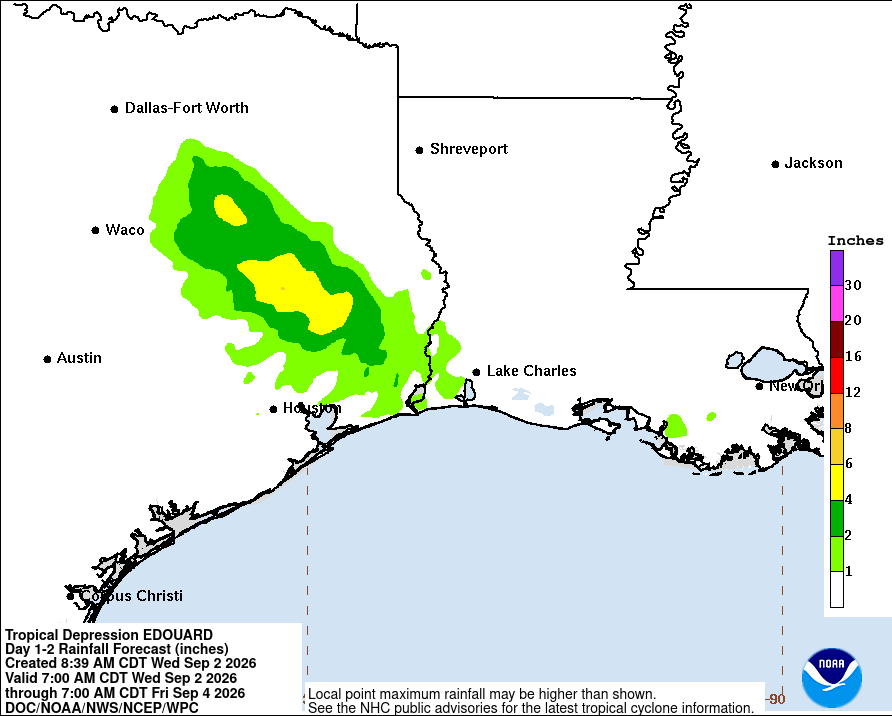
Edouard is now inland over east Texas with its center now located to the northwest of Lufkin. Heavy rain with significant amounts of flooding is currently occurring across east Texas with widespread rain totals of 4 to 8 inches already occurring from the upper Texas coast east of Houston northward into east Texas. Upwards of 20 inches of rain may have occurred already along a narrow area from parts of central Hardin County into south-central Tyler County.
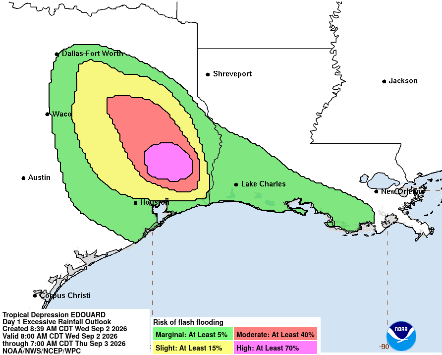
Additional heavy rain with even more significant flooding is expected from this afternoon through tonight and into Thursday across the Big Thicket and Piney Woods regions of southeast Texas. Heavy rain is also expected across much of east-central Texas to the southeast of Dallas-Fort Worth from this afternoon through tonight and into Thursday. Additional rain totals of 4 to 8 inches can be expected across east-central Texas.
It should be noted that the high-resolution model guidance are forecasting that intense thunderstorm cells will train over the same locations this afternoon and tonight across much of east-central Texas in the area between I-10 east of Houston & just north of Beaumont and almost to I-20 just southeast of Tyler. Significant flooding is extremely likely across this corridor of east-central Texas.
Finally, even though Edouard has weakened into a tropical depression, it has still maintained a well-defined circulation over east Texas. What’s left of this circulation is likely to gradually wind down by the time we get into Thursday as it moves into northeast Texas and southeast Oklahoma.
Elsewhere: The rest of the Atlantic, Caribbean and Gulf are very quiet, especially where we are now into what’s traditionally known as the peak of the hurricane season. All-in-all, it appears that no tropical development will occur across the Atlantic and Caribbean throughout the rest of this week through this weekend & probably into next week.
One area that I did want to mention is the very slight possibility that we could see tropical mischief over the far northern Gulf this weekend or early next week. Weather analysis reveals that there is a surface trough of low pressure that’s located over the northern Bahamas right now. This surface trough of low pressure is producing some deep convection in the area from the northern Bahamas to just northeast of the northern Bahamas.
It is expected that this trough of low pressure will head westward over the next couple of days & is likely to push into the northern Gulf during this weekend. The environmental conditions across the northern Gulf are expected to be marginally favorable for development & because of this, we might have to watch this system for possible tropical mischief throughout this upcoming Labor Day weekend.
A look at the latest model guidance reveals that they really don’t show much in the way of tropical development during this weekend into early next week. The reason for this seems to have to do with the possibility of this low pressure trough staying on land as it heads westward across the northern Gulf coast. The exception to this is the UKMET model which has hinted at development occurring very near the coasts of Alabama, Mississippi and southeast Louisiana as early as Friday or Saturday. Also, the European ensemble model guidance is showing up to 30 percent chance for tropical development from the eastern to the northern Gulf between Friday and Sunday.
At this point, while this trough of low pressure is certainly something to keep an eye on for possible tropical mischief between Friday and Monday over the northern Gulf, I think that the chances for significant development are very low.
What this trough of low pressure will more likely do is increase the thunderstorm chances across the Florida Peninsula during Thursday and Friday and then increase the thunderstorm chances along much of the northern Gulf coast throughout this upcoming weekend.