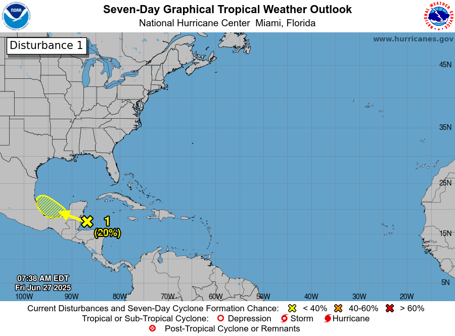
Area Of Disturbed Weather Located Over The Northwestern Caribbean: Satellite imagery and analysis of weather data indicated that there is an area of disturbed weather located over the northwestern Caribbean today. This disturbed weather is producing some deeper thunderstorm activity just north of northern coast of Honduras. This area of disturbed weather is expected to move towards the west-northwest and reach the Bay of Campeche during Saturday where development is a possibility by Sunday or Monday.
Diving a little deeper into the data reveals that the wind shear values are too strong to support immediate tropical development as 25-40 knots of wind shear are affecting much of the western and northwestern Caribbean. Also, any spin associated with this disturbed weather is located at the middle levels of the atmosphere. This says to me that development is unlikely over the next day or two due to unfavorable conditions and then land interaction with the Yucatan Peninsula.
It’s possible that some development could occur once this disturbed weather moves into the Bay of Campeche this weekend. The reason for this possible Bay of Campeche development is due to the combination of this system taking advantage of the curvature of the Bay of Campeche and the potential for lighter amounts of wind shear over the Bay of Campeche. The most likely time frame for potential development looks to be from Sunday into Monday and the chances for development look to be about 25-35 percent or so.
Two other things to note about this area of disturbed weather –
First is that even if development does not happen, this disturbed weather will bring heavy rainfall and possible flooding to Belize, Guatemala and southern and southeastern Mexico throughout this weekend. This heavy rainfall may then affect eastern and northeastern Mexico and possibly the Rio Grande Valley late this weekend into the first half of next week.
The second item to note is that right now this disturbance, whether it develops or not, poses no serious threat at all to the Texas coastline or any part of the US Gulf Coast.
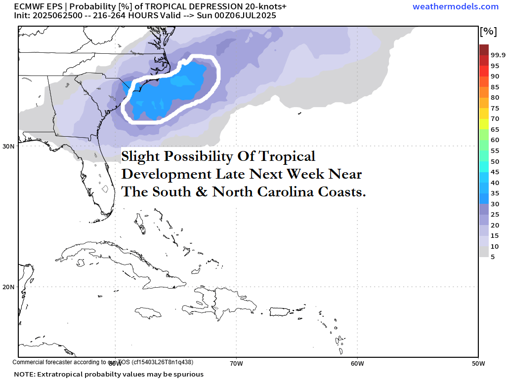
Tropical Development Is A Slight Possibility Near The Southeastern Coast Of The United States Late Next Week: There continues to be the possibility that we could see the occurrence of tropical development near the Southeast Coast of the United States late next week as a low pressure system forms near the tail end of a frontal boundary. This is a “classic” weather setup that can sometimes yield tropical development. What happens is that a frontal boundary stalls out and decays and a low pressure system then forms near the tail end of the front and cuts off from the front. The convergence and energy from the old front then feeds into the low pressure system and allows it to develop into a tropical system. This is something that will be monitored closely as we get into the second half of next week.
Some Of The Model Guidance is certainly hinting at the very real possibility that we will see development late next week. While the GFS model doesn’t show any sort of development, the Canadian model has been fairly consistent in forecasting possible development later next week. The latest Canadian model run shows a low pressure system spinning up near the coast of eastern North Carolina on Thursday of next week and then moving to the northeast well east and southeast of Cape Cod next Saturday. Interestingly, the Canadian model forecasts a second low pressure system to form near the South Carolina coast next weekend.
The European model seems to have backed off some on its forecast development near the Carolina coastline late next week.
As for the ensemble model guidance, the GFS ensemble model shows no development at all. The European ensemble model guidance is forecasting about a 25-30 percent chance for development near the Carolina coastline late next week into next weekend. This is a little lower chance of development by the European ensemble model guidance as compared to the last couple of days.
Here Are My Thoughts: While I do think that we may need to watch the area near the North and South Carolina coasts for possible development late next week into next weekend, I do think that the chances for development are fairly low. This means that this is nothing to be overly concerned about or worried about – just something to keep an eye on.
Needless to say, I will be keeping close tabs on the slight possibility for tropical development late next week near the Carolina coastline and will update you as needed.
The next tropical weather discussion will be issued on Saturday.