CrownWeather-final logo
CrownWeather-final-logo-mobile
icon burger
  • Pricing
  • Who is Crown Weather
  • CWS Support Services
  • Log In

Crown Weather
Discussions

The Twin Tropical Disturbances Of Invest 93-L & Invest 94-L Could Raise A Ruckus For Those Of You In The Bahamas, Bermuda & On The US East Coast

Wednesday, September 24, 2025 11:40 am by Rob Lightbown

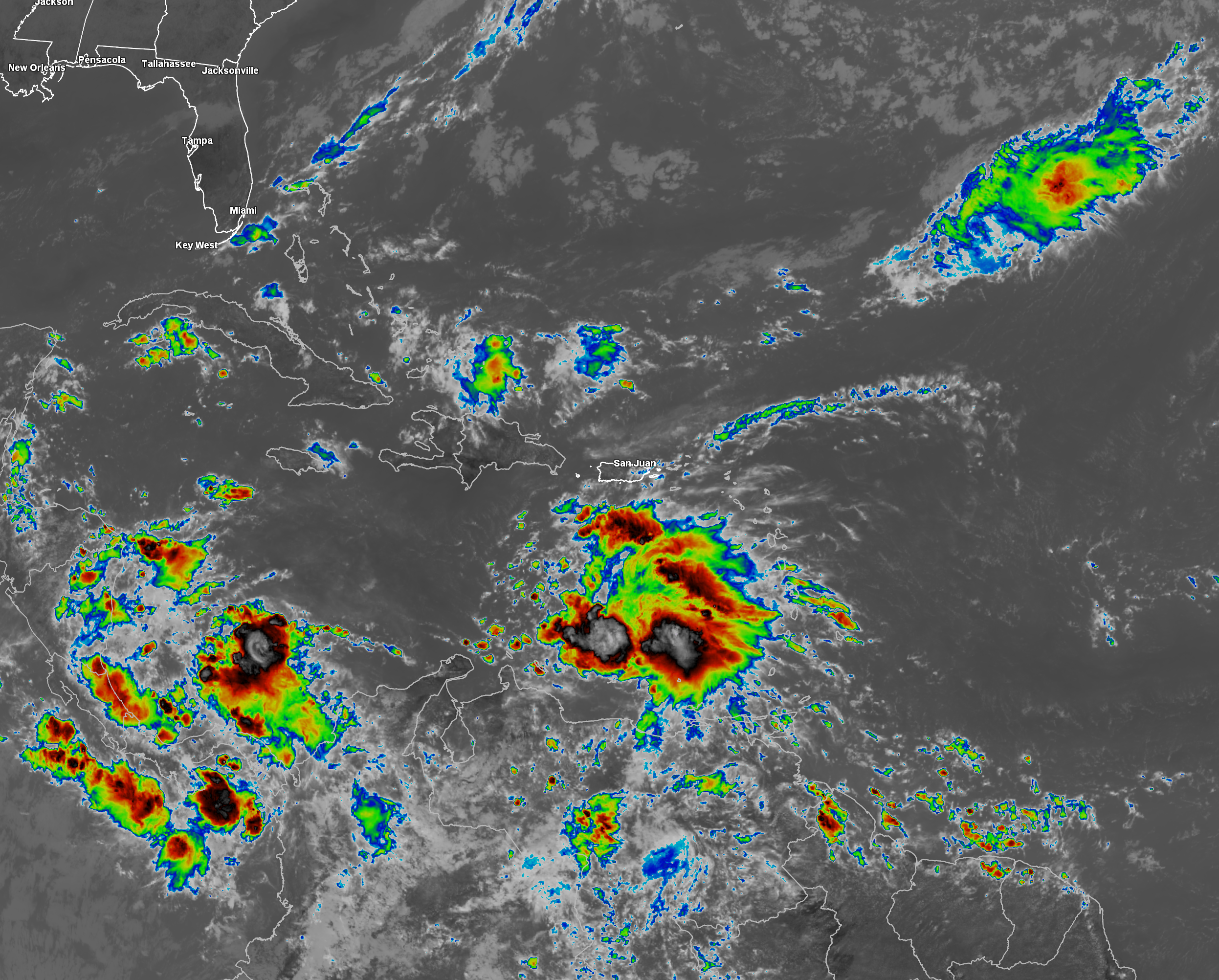
Two robust tropical disturbances, Invest 93-L (the easternmost disturbance) and Invest 94-L (the westernmost disturbance, are likely to develop into tropical storms and possibly hurricanes over the next few days & could very well become viable threats. The westernmost disturbance, Invest 94-L, is likely to track through the Bahamas & then be a very real threat to areas from Florida through the Carolinas to the Mid-Atlantic coast early next week. The easternmost disturbance, Invest 93-L, could end up being a threat to Bermuda early next week.

It needs to be emphasized that the overall forecast of both Invest 93-L and Invest 94-L is extremely uncertain as both systems will influence each other in both track and strength. In fact, these two disturbances could end up rotating around each other in what’s called the Fujiwhara effect.

Invest 94-L: First, to discuss the westernmost disturbance, Invest 94-L, which is located over the northeastern Caribbean.

Satellite imagery today reveals that the convection around Invest 94-L is disorganized & there seems to be 20-40 knots of west-northwesterly wind shear affecting it. Because of this, development is not expected for at least the next couple of days.

Beyond this, the forecast track and strength of Invest 94-L becomes highly uncertain once it reaches the Bahamas by early this weekend as it will be heavily affected by Invest 93-L.

My thinking is that Invest 94-L should track into the area around the Bahamas by this weekend. An upper level low pressure system over the Southeastern United States will produce a south to north upper level wind flow causing Invest 94-L to turn to the north by about Sunday and Monday. This is when the influence of Invest 93-L will come into play and thus will probably lead to all sorts of forecasting headaches as scenarios run everything from a track right into the Carolinas all the way to being yanked out into the open Atlantic. More on this later in this discussion.

Invest 93-L: Invest 93-L, which is the easternmost disturbance, seems to be organizing today with satellite imagery revealing an elongated area of convection. It seems likely that Invest 93-L will be the first one of the two disturbances to develop and in fact, it could be a depression as soon as later tonight or on Thursday.

With Invest 93-L being the easternmost disturbance, it’ll be a lot harder for it to close in on the East Coast of the United States. Instead, I could see it becoming a very real threat to Bermuda by early next week. That said, it’s possible that Invest 93-L could try to rotate to the north of Invest 94-L and try to track towards the northwest and west-northwest during next week leading it to try to come close to the New England coastline.

Again, the interaction between this disturbance and Invest 94-L is going to make for a very difficult and uncertain forecast.

The Interaction Between Invest 93-L & Invest 94-L Makes For An Extremely Uncertain & Complicated Forecast: Both Invest 93-L and Invest 94-L are expected to track in a westerly direction over the next couple of days. By this weekend, both disturbances will likely turn towards a northerly direction as they are guided on the western side of a high pressure ridge over the central North Atlantic.

The forecast then becomes very complicated as these two systems will get quite close to each other in distance & because of this, they will influence both the track and strength of both disturbances.

It’s actually possible that Invest 93-L and Invest 94-L will be close enough to each other next week, so that the Fujiwhara effect could occur. What is the Fujiwhara effect? It’s when the two circulations (Invest 93-L and Invest 94-L) become entangled with one another & end up rotating around a common pivot point. This is something that is uncommon in the Atlantic, but it can sometimes happen.

Most of the model guidance seem to want to keep these two systems distinct tropical systems, however, the guidance are not in agreement with each other on which system might be the stronger and more dominant one.

The European model, for example, forecasts that both Invest 93-L and Invest 94-L will be hurricanes by early next week.

The GFS model, on the other hand, show that the westernmost system (Invest 94-L) will be quite weak & Invest 93-L (the easternmost system) will be the one to become a hurricane. In fact, the GFS model forecasts that Invest 93-L will end up absorbing the circulation of Invest 94-L.

The Google Deep Mind AI model looks similar to the European model and shows the potential for two dueling hurricanes that will be close to each other in distance by early next week.

Bottom Line Is That If you live in Bermuda, the Bahamas, or on the East Coast from the Florida Peninsula through the Carolinas and the Mid-Atlantic coastline to Southern New England, keep close tabs on the progress of what is going on with these two systems. I cannot emphasize enough how uncertain the forecast is. When you get two systems like this in-close to each other, some very strange things can happen. Everything from significant land impacts to some part of the East Coast to both systems harmlessly heading out into the open Atlantic are possible.

Finally, the next two names on the list are Humberto and Imelda. I do think that the easternmost disturbance (Invest 93-L) will probably be Humberto and the westernmost disturbance (Invest 94-L) may end up becoming Imelda at some point.

The next tropical weather discussion will be issued on Wednesday.

Filed Under: CWS Weather Discussions

Invest 94-L Should Be Watched Closely In The Coming Days If You Are In The Bahamas Or Along The East Coast Of The United States

Tuesday, September 23, 2025 12:07 pm by Rob Lightbown

With Hurricane Gabrielle heading safely out into the open Atlantic, I want to concentrate a lot more on Invest 94-L, which poses a potential threat to the Bahamas & parts of the East Coast of the United States and Invest 93-L, which might pose some threat to Bermuda.

Invest 94-L Located Over The Lesser Antilles: Satellite imagery and weather analysis today indicates that the northerly wind shear that has been affecting this system has caused it to track more to the south than what the guidance indicated even yesterday. Because of this, it looks very likely now that Invest 94-L will continue to track right through the Lesser Antilles during the rest of today before it heads right over Puerto Rico and Hispaniola during Wednesday into Thursday.

This means that those of you in the Windward and Leeward Islands will continue to see occasional squally weather throughout the rest of today into tonight. This squally weather will affect much of the Virgin Islands, Puerto Rico and Hispaniola throughout Wednesday and will probably last into Thursday.

Strong northerly wind shear is expected to continue to affect Invest 94-L over the next 2-3 days or so and because of this, development is not expected anytime too soon. As we get into Friday and Saturday, however, the environmental conditions around this disturbance will become more favorable for development, just as its moving into the southeastern Bahamas.

A look at the latest model guidance reveals that it seems both the conventional models and the AI models now forecast development of Invest 94-L and also forecasts it to get quite close to the East Coast of the United States.

The Google Deep Mind AI model looks quite aggressive in showing Invest 94-L being a threat to not only the Bahamas but also to the Southeast coast of the United States during the early part of next week.

The European AI model also shows Invest 94-L being a threat to the Southeast coast of the United States during the early part of next week.

As for the conventional models, the GFS ensemble model guidance is further offshore than the AI models and most ensemble members show a close brush with the outer banks of North Carolina early next week.

The European ensemble model guidance looks further west than the GFS ensemble guidance with a few members pointing towards a coastal North Carolina impact early next week.

Here Are My Thoughts: As I mentioned yesterday, those of you in the Bahamas and along the US East Coast should keep a close eye on the progress of Invest 94-L as it could be a problem come late this weekend and early next week.

The environmental conditions around Invest 94-L are currently unfavorable for development, but are expected to become favorable when this system moves into the Bahamas this weekend. This means that we could very well have a developing tropical system right in the Bahamas by early this weekend.

The weather pattern during this weekend into early next week looks quite complicated & because of this, the overall track of whatever forms is highly uncertain. There’s the expectation that there will be a cutoff upper level low pressure system in place over the southeastern US with a high pressure ridge located over southeastern Canada. This is a pattern that is actually quite favorable for an East Coast tropical impact. That being said, the influence of the other tropical disturbance, Invest 93-L, located just to the east of Invest 94-L could lead to some high jinx in the forecast.

It’s possible that the interaction between Invest 94-L and Invest 93-L could cause both systems to completely miss the entire East Coast of the US, especially if the disturbance further east (Invest 93-L) gets stronger & has more influence on the overall weather pattern.

It’s equally as possible that the upper level low pressure system is able to capture Invest 94-L and guide it to the north-northwest towards the Southeast coast of the United States or the Mid-Atlantic coastline early next week.

Bottom line is that all interests along the East Coast from the Florida Peninsula to New England should monitor the progress of Invest 94-L. The area that I’m most concerned about in terms of any impacts are along the Carolina and Mid-Atlantic coastlines. That said, there is still A LOT to figure out with this system & how the overall weather pattern will affect it. Also, there’s the question on how Invest 94-L will interact with Invest 93-L. All-in-all, a very uncertain forecast.


Invest 93-L Located About 1000 Miles To The East Of The Lesser Antilles: Located to the east of Invest 94-L is another tropical disturbance, designated Invest 93-L. This disturbance is located about 1000 miles or so to the east of the Lesser Antilles.

Right now, Invest 93-L seems to be gradually organizing & probably will develop in the coming days. All signs seem to point towards Invest 93-L strengthening into a tropical storm and possibly a hurricane as it curves to the north away from the Caribbean, but towards Bermuda.

While there is potentially a threat to Bermuda early next week from Invest 93-L, it seems as if this system will curve far enough offshore to not be a threat to the Bahamas or the East Coast of the United States.

The next tropical weather discussion will be issued on Wednesday.

Filed Under: CWS Weather Discussions

The Atlantic Has Woken Up With Gabrielle & Two Other Areas Of Disturbed Weather To Closely Watch

Monday, September 22, 2025 11:46 am by Rob Lightbown

Hurricane Gabrielle: Gabrielle is rapidly strengthening today and it is now a major hurricane with 120 mph maximum winds.

Gabrielle is heading towards the north-northwest and it is fully expected that the hurricane will pass safely to the east of Bermuda later today. Beyond this, it is expected that Gabrielle will turn to the northeast and head out into the open Atlantic. In addition, it is expected that Gabrielle will continue to strengthen throughout the rest of today before it begins to weaken due to increasing amounts of wind shear and cooler ocean water temperatures.

Finally, it should be noted that the swells created by Gabrielle will affect Bermuda throughout the next few days. These swells will also affect areas of the US East Coast from the North Carolina coastline northward to the New England coastline over the next couple of days or so. These swells will lead to extremely rough surf and dangerous rip currents.


Area Of Disturbed Weather Located About 400 Miles To The East Of The Leeward Islands: Satellite imagery today indicates that there is a tropical wave that’s producing disorganized convection located just to the east of the Leeward Islands. This disturbance could be a system to really, really watch closely throughout this week for those of you in the Bahamas & along parts of the US East Coast from the Carolinas and points northward.

Analysis of the environmental conditions around this disturbance reveals that there is 30 knots of northerly wind shear affecting this system. This northerly wind shear is being produced by the outflow from Gabrielle & for now, these strong wind shear values will impede any sort of development. The environmental conditions may become more favorable for this disturbance to develop when it nears the Bahamas later this week.

A look at the model guidance reveals that while most of the models show this system reaching the Bahamas later this week, they have differing solutions on what might occur.

For instance, the GFS model has been pretty consistent in forecasting this system developing into a tropical system that impacts the southeastern Bahamas late this week. The GFS model then forecasts this system will head up the East Coast & directly impact the North Carolina Outer Banks next Monday before passing to the south of New England next Tuesday.

On the other hand, the European model forecasts this disturbance to struggle & not really develop at all. Instead, the European model forecasts that the disturbance that’s located to the east of this disturbance to develop instead.

As for the ensemble model guidance, the GFS ensemble model guidance has quite a few members showing development over or just east of the Bahamas late this week. From there, the GFS ensemble model guidance have many members showing a track just offshore of the US East Coast, but there are a few members that do show a direct impact to the North Carolina coastline & the Mid-Atlantic coast early next week.

The European ensemble model guidance has about 30-40 percent of its members forecasting development in the southeastern and eastern Bahamas on Friday into Saturday. From there, the European ensemble model guidance has most of its members keeping this system offshore of the East Coast of the US. That said, it does show a couple of members hinting at this system stalling just offshore of the Georgia and northeast Florida coast.

As for the Google Deep Mind AI model, a majority of its ensemble members show a developing tropical system in the Bahamas between Friday and Saturday. That said, there are a separate clustering of models that show this system developing in the Florida Straits. The clustering of models that forecast development in the Bahamas show a track northward that threatens areas from the North Carolina coastline northward to Southern New England. The other clustering of models that forecast development near the Florida Straits show a track into the eastern Gulf.

Here Are My Thoughts: I do think that we really need to keep a close eye on this particular disturbance as it could affect the Bahamas at the end of this week & then potentially get very close to some part of the East Coast of the United States.

While the conditions are currently unfavorable for development, these conditions do look a little more favorable for development near the Bahamas. Because of this, we could very well have a developing tropical system right in or very near the Bahamas at the end of this week.

As for the possible steering of this system. The upper level weather pattern near the East Coast of the United States this weekend into next week look to favor this system eventually turning to the north and northeast. The big question is how far west could this system get before it turns.

On one hand, it’s possible that a cutoff upper level low pressure system over the Southeastern United States could yank it quickly to the north and northeast leading it to brush the eastern Bahamas & then barely miss the East Coast of the United States.

On the other hand, it’s possible that this disturbance could be steered further to the west by the other tropical wave located further to the east. Should this occur, it could lead to this disturbance missing being pushed out by that upper level low & then meander near the Bahamas and the Southeast Coast of the United States early next week.

Given how high the uncertainty is with where this system might track & how strong it might get, I would closely keep an eye on it if you are in the Bahamas and anywhere from the Florida Peninsula through the Carolinas to the Mid-Atlantic States.

Finally, this disturbance is expected to bring some squally weather to the Leeward Islands & especially the northern Leeward Islands tonight through the day on Tuesday.


Area Of Disturbed Weather Located Halfway Between The Lesser Antilles & The West Coast Of Africa: The other disturbance to discuss today is currently located over the central Tropical Atlantic near about 40 West Longitude. This system seems to have a better chance of developing over the next few days as the environmental conditions are favorable. Fortunately, it looks fairly likely that this disturbance will stay to the north of the Lesser Antilles & not be a threat.

Looking beyond this, the model guidance all agree that this disturbance could move into an environment north of the Caribbean that is favorable for development. Because of this, we could have a tropical storm or a hurricane that tracks further west than what Gabrielle is currently tracking. This means that this particular disturbance could eventually become a threat to Bermuda around early next week.

As for the Bahamas and the East Coast of the United States, it currently looks as if an upper level trough over the western North Atlantic should steer this system away from the Bahamas and the US East Coast. That said, given the possible interaction with the other tropical wave, there is some uncertainty as to the final track of this system, but odds are that it should pass well east of the Bahamas and the US East Coast.

The next tropical weather discussion will be issued on Tuesday.

Filed Under: CWS Weather Discussions

Gabrielle Is Likely To Pass To The East Of Bermuda On Monday

Saturday, September 20, 2025 10:36 am by Rob Lightbown

Tropical Storm Gabrielle: Some westerly wind shear is affecting Gabrielle this morning as most of the convection is located just to the east of the low-level center. That said, the convection that is occurring today is quite intense & thus once the wind shear does decrease over Gabrielle, it’ll probably strengthen fairly quickly.

Gabrielle is heading in a northwesterly direction today and this northwesterly movement is expected to continue throughout this weekend. By Monday, it is expected that Gabrielle will turn to the north and northeast and pass well east of Bermuda during the day on Monday. From there, Gabrielle will likely head out into the open Atlantic and not be a threat to anyone.

As I already mentioned, the wind shear values over Gabrielle will likely decrease over the next couple of days and this should allow the storm to undergo some quick strengthening as we get into early next week. This means that Gabrielle will likely become a hurricane as soon as late Sunday and may end up peaking at around Category 2 strength during Monday and Tuesday, just as it’s passing to the east of Bermuda.

Not only does it look likely that Gabrielle will not be a threat to the Bahamas or the United States, but it also looks likely now that Gabrielle will pose no significant threat to Bermuda. That said, Gabrielle may still produce some rough surf and rip currents to Bermuda during the early part of next week.

Model Track Forecast:

Satellite Imagery:
Finally – Quiet conditions are expected throughout the rest of this weekend across the rest of the Atlantic, Caribbean and Gulf. There are no other areas to be concerned about in terms of development.

I’m still keeping a close eye on the area from the western Caribbean to the Bay of Campeche and the southern Gulf for later this month. At this point though, there are no changes at all to what I wrote in yesterday’s update. Those thoughts were that I do think that the area from the western Caribbean through the Bay of Campeche and the southern Gulf will definitely need to be watched closely for possible tropical development during the week of September 29. Nothing concrete or likely at this time, but it is something to keep an eye on.

The next tropical weather discussion will be issued on Monday.

Filed Under: CWS Weather Discussions

Gabrielle Is Expected To Strengthen This Weekend & Should Pass To The East Of Bermuda Early Next Week

Friday, September 19, 2025 9:51 am by Rob Lightbown

Tropical Storm Gabrielle: Gabrielle remains a sheared storm with most of the convection occurring to the east of its low-level center. That said, Gabrielle does look more organized than it did at this time yesterday.

Gabrielle is heading in a west-northwest to northwest direction today and it looks likely that it will move to the northwest throughout this weekend before it turns to the north and northeast by early next week. Additionally, the wind shear that has been affecting Gabrielle is expected to decrease during this weekend & this should allow the storm to strengthen to probably a hurricane sometime between Sunday and Monday. Gabrielle will then maintain its hurricane strength as it heads in a northeasterly direction next week.

It continues to look very likely that Gabrielle will not be a threat to the Bahamas and the United States.

As for Bermuda – At the time of this writing, it looks more likely than not that Gabrielle will pass far enough to the east of the island to not be a serious threat. That being said, those of you in Bermuda should keep close tabs on the progress of the storm throughout this weekend just in case it trends closer to the island. For now though, the biggest threat from the storm looks to be rough surf and rip currents.

Model Track Forecast:

Satellite Imagery:

Finally – It looks like it will be a quiet weekend across the rest of the Atlantic, Caribbean and Gulf with no other areas to be concerned about in terms of development. I’m still keeping a close eye on the area from the western Caribbean to the Bay of Campeche and the southern Gulf for later this month. At this point though, there are no changes at all to what I wrote in yesterday’s update. Those thoughts were that I do think that the area from the western Caribbean through the Bay of Campeche and the southern Gulf will definitely need to be watched closely for possible tropical development during the week of September 29. Nothing concrete or likely at this time, but it is something to keep an eye on.

The next tropical weather discussion will be issued on Saturday.

Filed Under: CWS Weather Discussions

Gabrielle Continues To Struggle Mightily But May Begin To Strengthen Sometime This Weekend Or Early Next Week

Thursday, September 18, 2025 1:12 pm by Rob Lightbown

Tropical Storm Gabrielle: Gabrielle is on life support today as satellite imagery shows little or no deep convection near the center of circulation. It seems that a series of upper-level low pressure systems are imparting dry air and westerly wind shear onto Gabrielle. In fact, it looks likely that this system will continue to struggle mightily over the next couple of days or so & it’s pretty likely that Gabrielle will be downgraded to a depression at some point over the next couple of days.

Looking beyond this, the environmental conditions are forecast to become more favorable for strengthening at some point this weekend. These more favorable conditions should lead to Gabrielle strengthening and then probably passing to the east of Bermuda around the early part of next week. That being said, some of the model guidance do still show Gabrielle moving very close to or right over the island & this is something that needs to be watched.

It is highly likely that Gabrielle will not be a threat to the Caribbean Islands and will turn into the Atlantic well before reaching the Bahamas and the United States.

As for Bermuda – As I just mentioned, those of you on the island of Bermuda will want to keep a close eye on the forecasts surrounding Gabrielle. While most model guidance do suggest a path that keeps it east of Bermuda, the very disorganized and weak state of the storm suggests that there is quite a bit of uncertainty as to where a new center may ultimately form. Because of this, I would keep a close eye on this storm, in case it does impact you early next week.

Model Track Forecast:

Satellite Imagery:


Elsewhere Across The Atlantic, Caribbean & Gulf: Satellite imagery, weather analysis and radar data indicates that the combination of a tropical wave and an upper-level trough of low pressure is bringing heavy showers and thunderstorms to both the British and US Virgin Islands, as well as to eastern parts of Puerto Rico. Flooding has already been reported in parts of the Virgin Islands.

It is expected that these heavy showers and thunderstorms will continue to affect Puerto Rico and the Virgin Islands through tonight before these inclement conditions spread into Hispaniola and the southeastern Bahamas tonight and Friday. Be aware that flash flooding and mud slides will certainly be a hazard through Friday.

No tropical development is expected with either the tropical wave or the upper level trough.

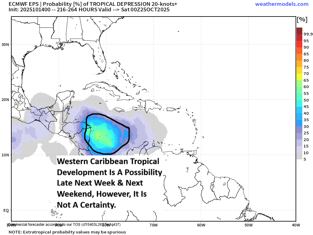
As I have mentioned in previous discussions, we might have to really start watching the western Caribbean and the Bay of Campeche as soon as late next week and next weekend.

The Google Deep Mind AI model is particularly very aggressive in forecasting tropical development to occur in the western Caribbean around next Saturday. Most of the ensemble members of the Google AI model then forecasts anything that develops to head into the Gulf of Mexico during the first half of the week of September 29. I’m still pretty skeptical on completely believing this model as it is still very new & hasn’t really been test driven a whole lot this season.

Looking at the other ensemble model guidance, the GFS ensemble model guidance does show a few members that develop a tropical system in the northwestern Caribbean around late next weekend. Those members that show development actually increase around October 1 across the Bay of Campeche and the southern Gulf.

As for the European ensemble model guidance, it seems that about 20-30 percent of its members forecast development in the western Caribbean next weekend. It should be noted that, much like the GFS ensemble guidance, the number of members that show development increase dramatically around October 1 in the southern Gulf.

My take on this is that I do think that the area from the western Caribbean through the Bay of Campeche and the southern Gulf will definitely need to be watched closely for possible tropical development during the week of September 29. I think that the Google AI model might be too quick in showing development & I’m leaning more on the side of the conventional models that show the development occurring between September 29 and October 1. Either way, this is something to certainly keep an eye on.

The next tropical weather discussion will be issued on Friday.

Filed Under: CWS Weather Discussions

Tropical Storm Gabrielle Has Formed Over The Central Tropical Atlantic & Bermuda Should Continue To Closely Watch This System

Wednesday, September 17, 2025 11:26 am by Rob Lightbown

Tropical Depression #7 (Now Tropical Storm Gabrielle): I’m actually surprised that they upgraded Invest 92-L to a tropical depression earlier this morning given what it looks like on satellite imagery (now, I’m really surprised they upgraded it to Tropical Storm Gabrielle).

Satellite imagery today reveals that this system seems to lack any sort of a defined low-level circulation. In fact, it still looks like a tropical wave to me, especially with how elongated and disorganized it is.

Anyways, now that we have Tropical Depression 7 designated by the National Hurricane Center, the depression seems to be moving on a west-northwest to northwest direction and this general direction is likely to continue for the next few days. Because of this, it is quite likely that this system will pass well to the east and northeast of the Lesser Antilles during this weekend.

Beyond this, it continues to look quite possible that this system will be a threat to the island of Bermuda around Tuesday of next week. Also, this system is probably going to struggle to strengthen over the next few days due to moderate amounts of wind shear & ingestion of dry air. Once we get into this weekend and early next week, however, this system may move into an environment that’s more favorable for strengthening & because of this, Bermuda may have a hurricane threat around Tuesday of next week. The uncertainty lies to whether the depression will track directly over the island or pass to the east of the island. My recommendation to those of you in Bermuda is to monitor this system extremely closely over the coming days.

As for the Bahamas and the East Coast of the United States, it continues to look fairly likely that an upper level trough located over the western North Atlantic will keep this system from heading towards the Bahamas or the East Coast of the United States. Instead, this upper level trough will deflect the depression and turn it to the north and northeast away from the Bahamas and the US East Coast. It should be noted though that if this system does become a strong hurricane in the middle of the North Atlantic, it could send another round of rough surf and rip currents to the East Coast of the United States during next week.

Model Track Forecast:

Satellite Imagery:


Elsewhere Across The Atlantic, Caribbean & Gulf: There is another tropical wave that’s located over the far eastern Tropical Atlantic that’s producing some disorganized convection. All-in-all, this system may not really develop at all due to marginally favorable environmental conditions. Also, it is expected that this wave will eventually curve out into the open Atlantic well before it reaches the Lesser Antilles.

Looking much closer to the United States, satellite imagery and weather analysis indicates that there is a surface trough of low pressure stretched from the far northwestern Caribbean northeastward to across central and south Florida. There is scattered convection occurring all along the surface trough. It is expected that this surface trough of low pressure will remain in place & because of this, expect a continuation of scattered showers and thunderstorms across the northwestern Caribbean, the Florida Keys, South and Central Florida and the northern Bahamas over the next couple of days or so.

It should be noted that some of the model guidance forecast that this mess will evolve into the development of a surface low pressure system over the Bahamas around this weekend. While this is something that will be watched closely, it appears that the environmental conditions may just be too unfavorable for any sort of tropical development.

Finally, we may have to turn our eyes towards the western Caribbean and the Bay of Campeche as soon as late next week.

The ensemble members of the GFS model show a uptick in members forecasting development in the Bay of Campeche between about Wednesday and Friday of next week.

Meanwhile, the European ensemble model guidance shows a little increase in the chances for tropical development over the Bay of Campeche as well as over the western Caribbean next weekend.

The Google Deep Mind AI ensemble model is pointing towards the northwestern Caribbean being a spot to watch for tropical development around next weekend.

All-in-all, the gradual increase in tropical development chances over the western Caribbean and Bay of Campeche in about 10 days or so from now does not surprise me & it fits in to what I think will be an area to closely watch for development chances between September 26 and October 10.

The next tropical weather discussion will be issued on Thursday.

Filed Under: CWS Weather Discussions

Bermuda Should Watch Invest 92-L Closely As It Could Be A Threat In About A Week From Now; A Coastal Storm Will Continue To Affect The Mid-Atlantic Coast Throughout The Rest Of Today

Tuesday, September 16, 2025 9:27 am by Rob Lightbown

Coastal Storm Located Near The North Carolina Outer Banks: Weather analysis of satellite imagery and marine weather observations indicates that the coastal storm that we’ve been watching is currently located about 75 miles to the east-northeast of Cape Hatteras at the time of this writing. It is expected that this low pressure system will continue to track slowly along the outer banks of North Carolina before crossing the coast near Albemarle Sound by later today. From there, this low pressure system will slow down and weaken near the Virginia-North Carolina border tonight.

The gustiest winds from this storm system will occur across northeastern North Carolina and southeastern Virginia throughout the day today through tonight. Wind gusts of up to 35-45 mph can be expected, especially along the immediate coast.

In addition, bands of moderate to heavy rain associated with this low pressure system will affect mostly northeastern North Carolina and eastern and southeastern Virginia throughout the rest of today through tonight. Additional rainfall totals of 2 to 3 inches with locally higher amounts can be expected over the next 12-24 hours.

Finally, there is the expectation of some additional minor coastal flooding across eastern North Carolina and the outer banks, eastern and southeastern Virginia, coastal Maryland and coastal Delaware during the high tides the rest of today, tonight and Wednesday.


Invest 92-L Located Halfway Between The Lesser Antilles & The West Coast Of Africa: Invest 92-L is certainly organizing this morning as satellite imagery reveals that the disturbance is producing quite a bit in the way of deeper convection. Additionally, there is a good amount of low-level rotation noted in satellite loops.

All indications seem to point towards Invest 92-L developing into a depression over the next couple of days or so & then going on to become a tropical storm and even a hurricane. The next name on the list is Gabrielle.

Invest 92-L is expected to head in a west-northwest to northwest direction throughout the rest of this week and this will most certainly keep this system well north of the Lesser Antilles and the northeastern Caribbean by this weekend.

Beyond this, I think that the island of Bermuda really needs to keep a close eye on the progress of Invest 92-L as it could pose a threat to you in about a week from now. The latest ensemble guidance from the GFS and European models show a majority of their members either threatening or directly impacting the island of Bermuda around next Tuesday. Additionally, some of the model guidance are showing that Invest 92-L could be a strong hurricane when it passes near or over Bermuda, so this is something to certainly keep a very close eye on.

As for the Bahamas and the East Coast of the United States, it continues to look fairly likely that an upper level trough located over the western North Atlantic will keep Invest 92-L from heading towards the Bahamas or the East Coast of the United States. Instead, this upper level trough will deflect Invest 92-L and turn it to the north and northeast away from the Bahamas and the US East Coast. It should be noted though that if Invest 92-L does become a strong hurricane in the middle of the North Atlantic, it could send another round of rough surf and rip currents to the East Coast of the United States during next week.

Model Track Forecast:

Satellite Imagery:

The next tropical weather discussion will be issued on Wednesday.

Filed Under: CWS Weather Discussions

We Continue To Watch A Coastal Storm Near The North Carolina Outer Banks & Invest 92-L That Is Located Over The Central Tropical Atlantic

Monday, September 15, 2025 1:56 pm by Rob Lightbown

Coastal Storm Located Near The North Carolina Outer Banks: The latest weather analysis indicates that there is a coastal low pressure system that’s located about 100 miles to the southeast of the North Carolina Outer Banks.

This low pressure system is expected to slowly move in a northwesterly direction and move inland over eastern North Carolina by Tuesday.

It is then expected that this low pressure system will sit and spin in the area around eastern North Carolina and southeastern Virginia through Wednesday before it weakens and heads out into the open Atlantic.

There is likely to be a tight pressure gradient between this low pressure system and an area of high pressure located over the northeastern United States. This will lead to some quite gusty onshore winds occurring across eastern North Carolina, southeastern Virginia, coastal Maryland and much of Delaware from the rest of today through Tuesday and into Wednesday. Wind gusts on the order of 35-45 mph can be expected at times, especially along the immediate coast.

In addition, bands of moderate to heavy rain on the west, northwest and north sides of this low pressure system will affect much of eastern North Carolina, the North Carolina Outer Banks, southeastern Virginia, southern and eastern Maryland and eastern Delaware from the rest of today through Tuesday and into Wednesday. Rainfall totals of 2 to 4 inches with locally higher amounts can be expected.

Finally, the onshore gusty winds will probably lead to at least some minor coastal flooding occurring across eastern North Carolina and the outer banks, eastern and southeastern Virginia, coastal Maryland and coastal Delaware during the high tides this afternoon, tonight, Tuesday, Tuesday night and Wednesday.


Invest 92-L Located Over The Central Tropical Atlantic: The tropical wave that we have been watching over the last few days has been designated Invest 92-L by the National Hurricane Center. At the time of this writing, Invest 92-L is located over the central Tropical Atlantic near 40 West Longitude.

Satellite imagery today reveals that Invest 92-L is producing some deeper convection now, however, this system is fairly disorganized and has a ways to go before becoming a depression or a tropical storm. That said, loops of satellite imagery does show that there is a wide area of low-level turning with this wave and the overall size of this wave is fairly large. This says to me that when Invest 92-L does develop into a tropical cyclone, it may be a rather large storm in overall size.

The environmental conditions around Invest 92-L remain marginally favorable for development & that is being generous. There is still an axis of strong wind shear and dry air located just to the north of this system that is being produced by an upper level low pressure system. This should keep Invest 92-L in-check in terms of how much it can develop over the next few days or so.

It looks very likely that Invest 92-L will head in a west-northwesterly direction throughout this week and this will likely keep this system to the north of the Lesser Antilles and the northeastern Caribbean by late this week and this weekend.

Looking beyond this, I do still think that we will see Invest 92-L organize and strengthen once it is located to the north of Lesser Antilles this weekend. In fact, some of the model guidance are pointing towards the possibility of this system being quite a strong hurricane at some point when it’s located in the North Atlantic.

Additionally, model guidance seems to suggest that there will be an upper level trough in place over the western North Atlantic this weekend into next week. This should put up a barrier of sorts & keep this system from heading towards the Bahamas or the East Coast of the United States. Instead, it looks more plausible that Invest 92-L will head to the north and may end up threatening or directly impacting the island of Bermuda near the middle part of next week.

All-in-all, this system continues to pose no direct threat to the Caribbean, the Bahamas or the United States. The only area that this system may be a threat to is the island of Bermuda around the middle part of next week. It should be noted though that if this system does become a strong hurricane in the middle of the North Atlantic, it could produce another round of rough surf and rip currents along the East Coast of the United States during next week.

Model Track Forecast:

Satellite Imagery:

The next tropical weather discussion will be issued on Tuesday.

Filed Under: CWS Weather Discussions

A Coastal Storm Will Affect Areas From Eastern North Carolina To The Mid-Atlantic States With Locally Heavy Rain, Gusty Winds & Some Coastal Flooding From Late Monday Until Thursday

Sunday, September 14, 2025 1:31 pm by Rob Lightbown

A Coastal Storm Will Bring Locally Heavy Rain, Gusty Onshore Winds & Some Coastal Flooding To The Mid-Atlantic States From Late Monday Until Thursday: Weather analysis today reveals that there is a low pressure system that is located about 175 miles to the southeast of Wilmington, North Carolina.

This low pressure system is expected to strengthen some and head towards the outer banks of North Carolina by Monday night. It is then expected that this low pressure system will sit and spin in the area between the outer banks of North Carolina and southeastern Virginia during Tuesday and Wednesday before it weakens and heads out into the open Atlantic.

There is likely to be a tight pressure gradient between this low pressure system and an area of high pressure located over the northeastern United States. This will lead to some quite gusty onshore winds occurring across eastern North Carolina, southeastern Virginia, coastal Maryland and much of Delaware during Tuesday and Wednesday. Wind gusts on the order of 30-45 mph can be expected at times, especially along the immediate coast.

In addition, it is also looking likely now that there will be heavy bands of soaking rain to occur across much of eastern North Carolina, central and eastern Virginia, much of Maryland and much of Delaware. Across these areas, rain totals of 1 to 3 inches can be expected from late Monday until Thursday morning.

Finally, the onshore gusty winds will probably lead to at least some minor coastal flooding occurring across eastern North Carolina and the outer banks, eastern and southeastern Virginia, coastal Maryland and coastal Delaware during the high tides on Tuesday, Tuesday night, Wednesday and Wednesday night.

Now, will this low pressure system become a sub-tropical or tropical storm? At this point, I think that this low pressure system will probably remain non-tropical in nature. That being said, some of the model guidance does hint at the possibility of it acquiring some sub-tropical elements to it around Tuesday. Any sub-tropical development of this system looks to be relatively short-lived.

Those of you in eastern North Carolina and the outer banks, eastern and southeastern Virginia, eastern Maryland and Delaware, be aware that the weather is going to be very inclement starting as soon as Monday afternoon, but especially during Tuesday and Wednesday. Expect on and off heavy rain, gusty easterly winds that gust up to 30-45 mph at times and overwash at the beaches at the time of high tide.


Tropical Wave Located Over The Eastern Tropical Atlantic: Satellite imagery and weather analysis reveals that the tropical wave that’s located over the eastern Tropical Atlantic near about 32 West Longitude is looking a little more convectively active than it did yesterday. Still though, this wave is disorganized as it appears that there are two competing areas of circulation that are located along the wave axis. Additionally, this wave is being affected by some dry and stable air.

The combination of disorganized look of the wave and the dry and stable air will lead to slow development of this system over at least the next couple of days.

Eventually, this wave should consolidate into one concentrated circulation center & once this occurs, the rate of development will begin to increase some. The various model guidance such as the GFS and European models suggests that we’ll begin to see a little more development from this wave by about Thursday or so. That said, the environmental conditions may still be a bit unfavorable for more robust development due to strong wind shear from an upper level low pressure system located to the northwest of this system.

My thinking is that we probably will not see any sort of robust strengthening from this wave until it moves to the north of the Lesser Antilles where the conditions look much more favorable for strengthening. Because of this, I think we’ll see strengthening capped at about a tropical depression or a low end tropical storm as it moves through the central Tropical Atlantic and to the north of the Lesser Antilles by next weekend. Once this system begins to track well north of the Lesser Antilles and towards Bermuda, we should see much more robust strengthening. In fact, the GFS and European ensemble guidance are hinting at a hurricane threat to Bermuda in about 10 days from now.

As for a track of this system, it seems that a majority of the operational and ensemble model guidance are showing a track that keeps this wave well north of the Lesser Antilles next weekend. In fact, the ensemble guidance seem to be trending towards a path that keeps this system far enough away from the Lesser Antilles to not be a problem.

It should be noted that the ensemble guidance and the AI models do point to a possible threat to the island of Bermuda in about 10 days from now & this is something to be watched closely over the next week or so.

All-in-all, this system continues to pose no threat to the Caribbean, the Bahamas or the United States. The only area that this system may be a threat to is the island of Bermuda in about 10 days from now.

The next tropical weather discussion will be issued on Monday.

Filed Under: CWS Weather Discussions

  • « Previous Page
  • 1
  • …
  • 3
  • 4
  • 5
  • 6
  • 7
  • …
  • 14
  • Next Page »

© 2026. Website Developed by AnoLogix. Privacy | Legal | Terms of Use