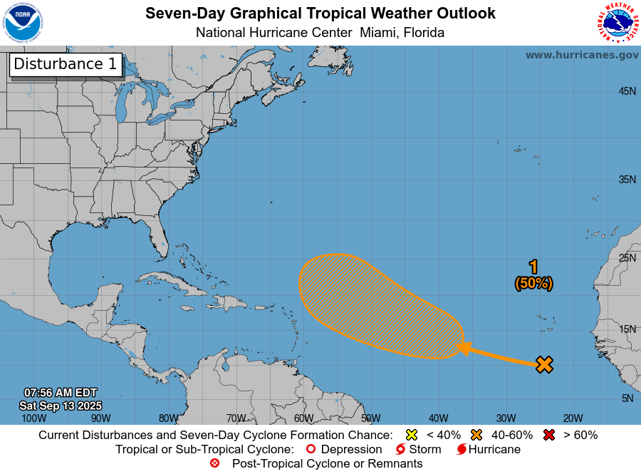
Tropical Wave Located Over The Far Eastern Tropical Atlantic: There is a tropical wave that’s located over the far eastern Tropical Atlantic near about 20-25 West Longitude that is producing very disorganized convection. Much like many of the other waves that we have seen this season, there is some dry air and wind shear that is affecting this wave & because of this, any development will be very slow to occur over the next several days.
It is expected that this wave will move in a general west-northwestward track over the next few days and is expected to reach the central Tropical Atlantic in about 2-3 days from now. Again, the overall environmental conditions do not look favorable at all for any sort of quick development. Instead, we should probably see slow to very slow development throughout this weekend into early next week.
There are differences between some of the deterministic operational models and their ensembles on where this wave may ultimately go.
For instance the European operational model forecasts that this system may make a very close brush with the northern Leeward Islands around next Sunday. Meanwhile, a majority of the members of the European ensemble model guidance shows a curve far enough to the northwest to miss the northeastern Caribbean next weekend.
Now, both the GFS operational model and the GFS ensemble model guidance show a far enough track to the north to completely miss the northeastern Caribbean in about a week from now.
As for the AI models – The Google Deep Mind model suggests a track that keeps this system far enough to the north to miss the northeastern Caribbean. Interestingly, the European AIFS model does suggest a very close brush with the northern Leeward Islands next Sunday. That being said, a majority of the ensembles of the European AIFS model does show a far enough north track to completely miss the northeastern Caribbean.
Here Are My Thoughts: As I mentioned yesterday, I do think that we’ll see slow to very slow development of this wave over the next several days as it heads in a west-northwestward motion.
As for a possible track, I do think that a large upper-level low pressure system that’s located over the central North Atlantic should be able to pull this wave far enough to the north during next week leading it to completely miss the eastern and northeastern Caribbean during next weekend.
Looking beyond this, the rate of development may increase once this system moves to the north of the Caribbean and gets to the other side of that upper-level low pressure system. It’s then possible that this system could end up becoming a threat to the island of Bermuda by around September 23. That said, it’s far too soon to say with any certainty as to whether this system will pass to the west, to the east or right over Bermuda.
Finally, all indications seem to point towards this system not being a threat to the Caribbean, the Bahamas or the United States. Again, there could be some sort of threat to Bermuda in about 10 days from now.
Elsewhere Across The Atlantic, Caribbean & Gulf: A look at the weather analysis today, there is a frontal boundary that extends from near the Florida Straits and the northern Bahamas east-northeastward into the north Atlantic.
I did want to mention that I am keeping an eye on a low pressure system that’s located along this front. This low pressure system is located over the northern Bahamas & it’s possible that this storm system could bring gusty onshore winds and some rain from the Carolinas northward into the coastal Mid-Atlantic states from this coming Tuesday until Thursday.
There are disagreements between the regular models and the AI models on what might occur with this low pressure system. On one hand, the operational GFS and European models show an offshore track, which would lead to little or no effects to the Mid-Atlantic coast or the Carolinas. On the other hand, the European AI model shows a track that keeps this low pressure system right on the coast from the outer banks of North Carolina northward through eastern Virginia, Maryland and Delaware. This in-close track would lead to some very gusty onshore winds, bands of heavy rain & some coastal flooding across the Mid-Atlantic states into eastern North Carolina starting on Tuesday and continuing through Wednesday and ending on Thursday.
At this point, I would say to just keep an eye on this low pressure system & be aware that it could bring some very inclement weather to eastern North Carolina & the outer banks, coastal Virginia, Maryland and Delaware from Tuesday to Thursday. I also think that this low pressure system will probably stay non-tropical, but given the possible tight pressure gradient between this low pressure system & a big high pressure system over the northeastern United States, the onshore winds along the Mid-Atlantic coast could be quite gusty with gusts on the order of 30-45 mph possible.
Looking elsewhere, there is a tropical wave that will be moving through the Lesser Antilles throughout this weekend. This wave will bring localized squally weather to much of the Lesser Antilles throughout this weekend. That said, tropical development is not expected from this wave.
The next tropical weather discussion will be issued on Sunday.