Tropical Development Is A Possibility Near The Carolinas Later This Week: A stationary frontal boundary that stretches from South Florida and the Bahamas northeastward to well offshore of the East Coast of the United States may become the focus for some sort of tropical development later this week.
Model guidance such as the GFS and the European model seem to be agreeing that a piece of energy will break off from the frontal boundary in a couple of days from now and head north and then northeastward reaching the South Carolina coast by Thursday where a low pressure system looks to form. Moisture, energy and convection associated with this low pressure system will combine with some convergence along the coast to help to possibly form a tropical system near the South Carolina and North Carolina coast by Thursday and Friday.
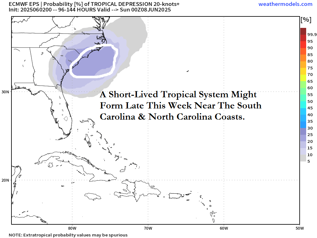
In addition, the European ensemble model guidance is showing upwards of a 20-25 percent chance for tropical development near the North and South Carolina coast late this week into this weekend.
Here Are My Thoughts: I do think that we will certainly see the development of a low pressure system near the South Carolina coast by Thursday that heads for coastal North Carolina by Friday. Any low pressure system should then track offshore of the Mid-Atlantic coast by Saturday as an eastward moving cold front pushes it offshore.
In addition to this, there is the possibility, albeit a low one right now, that this low pressure system could become a short-lived tropical depression or low end tropical storm as it moves near or just barely offshore of the coasts of northeastern South Carolina and southeastern and eastern North Carolina later Thursday and Friday.
Any system, whether it becomes a tropical depression/tropical storm or not, is likely to bring squally weather to the immediate coasts of South Carolina and southeastern and eastern North Carolina on Thursday and Friday.
Before that though, squally weather connected to the stationary front will affect South Florida and the Bahamas the rest of today through Tuesday. The piece of energy that breaks off from the front and lifts northward is then expected to bring squally weather to eastern and northeast Florida and southeastern Georgia on Wednesday.
I will be keeping close tabs on this possible short-lived tropical development closely and will keep you updated, especially since it’s only a few days away and it’ll be in-close to the coast.
Latest Update On The Very Low Possibility Of Western Caribbean Tropical Development Next Week Or So: One we get into next week and the week of June 16, an upward motion pulse of the Madden Julian Oscillation will move into the Atlantic. This upward motion pulse of the Madden Julian Oscillation will help to foster stormier weather around Central America into the western Caribbean during next week into the weekend of June 14.
It’s still way too soon to really tell with any accuracy whether tropical development will occur over the western Caribbean from this storminess or not.
One thing that is definitely for sure is that you should ignore the GFS model’s constant forecast of a hurricane in the Gulf next week. This is a very common bias of the GFS model this time of year and it’s outlandish model forecasts for 10-15 days away should be ignored.
Other model guidance members such as the European model continues to forecast no tropical development in the western or northwestern Caribbean through the middle part of this month.
Here Are My Latest Thoughts: My thinking right now is that all of this week through this weekend will be quiet across the Gulf and the western Caribbean in terms of tropical development.
As we get into next week, the presence of an upward motion pulse of the Madden Julian Oscillation should help to produce squally and stormy weather across much of the western Caribbean that will also affect the Yucatan Peninsula, Belize, the Cayman Islands and western Cuba.
It’s then possible (although an extremely low possibility right now) that we could see a tropical depression try to form over the western or northwestern Caribbean very late next week into the weekend of June 14-15.
This is something that still has my attention and is something that I will continue to keep a close eye on.
The next tropical weather discussion will be issued on Tuesday, which will have the latest on the possibility of tropical development near the Carolina coastline later this week.