

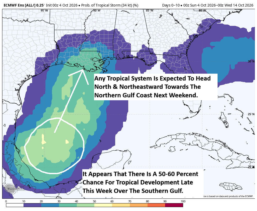
It appears that the chances of tropical development occurring in the southern Gulf later this coming week have increased some as compared to even yesterday. Latest weather data as of today seems to be pointing towards the possibility of a tropical storm or even a sub-tropical storm to form over the southern Gulf during the second half of this week & then heading northward or northeastward towards the northern Gulf coast by next weekend. This could lead to a large & very wet storm to impact much of the northern and parts of the eastern Gulf Coast by next weekend.
The catalyst for this potential tropical development is going to be a low pressure system forming near the tail end of a frontal boundary that’ll be draped across the Gulf during this week. It appears that this low pressure system will form over the southern Gulf by midweek within an environment that could be favorable for development due to low wind shear and some very warm ocean water temperatures. This is why there has been an uptick in the chances for tropical development by the various weather forecast guidance.
A look at the most recent model guidance reveals that guidance such as the European model shows a very wet and elongated sub-tropical storm that brings very heavy rain to the northern Gulf Coast by next weekend. Other guidance such as the GFS model shows a much more cohesive storm system that becomes a tropical storm over the southern Gulf by late this week. The GFS model then forecasts this system to head for the central Gulf Coast as a tropical storm by next weekend.
The Google Deep Mind ensemble model is now showing about a 50 percent chance for tropical development over the southern Gulf as early as Thursday. A majority of the ensemble members then show a track that takes this system towards the northern Gulf coast by next weekend.
Meanwhile, the European ensemble model guidance is actually showing an 80 percent chance for a tropical depression to form over the southern Gulf late this week. It should be noted that 40 percent of those members are forecasting this system to become a tropical storm. A majority of the ensemble members then show this system to head for the central Gulf Coast by next weekend.
Here Are My Thoughts: One thing that’s for sure is that we will definitely see a low pressure system form over the southern Gulf as soon as late Tuesday or Wednesday. The environment over the southern Gulf definitely looks to be favorable for tropical development of this low pressure system. A look at the current wind shear environment over the Gulf reveals that there is only 5-15 knots of wind shear occurring over much of the central and southern Gulf and I expect to see these low wind shear conditions to continue throughout this coming week. Because of this, I do think that there’s a pretty high chance now that we will see tropical development occur in the southern Gulf between Wednesday and Friday. I put the chances of tropical development at about 50-60 percent right now.
Now, where could this tropical system go? It is expected that an upper-level trough of low pressure will be in place over the eastern United States throughout this coming week right through next weekend. It appears that this upper-level trough will pull this tropical system northward or northeastward causing it to head for the northern Gulf Coast somewhere between southern Louisiana and the Florida Panhandle by next weekend.
The question then becomes what will the environmental conditions be like over the northern Gulf late this week and next weekend. It is possible that there could be some very strong amounts of wind shear to be in place over the northern Gulf & if this happens, it would cause this tropical system to weaken and transform into a very large, very messy and very wet non-tropical low pressure system by the time it reaches the central Gulf Coast. Now, there is the possibility that the wind shear values could be lower and if this occurs, it could mean a system that comes ashore along the central Gulf Coast as a tropical storm instead next weekend.
The potential for southern Gulf tropical development will be something to definitely keep an eye on throughout this week and I will have all sorts of updates for you as needed. At the minimum, I think that we’re probably looking at a large, messy and very wet system that brings quite a bit of rain to much of the northern Gulf Coast next weekend. It should be mentioned that if this system does come in as a tropical storm, then we’d be looking at gusty winds & very rough surf to accompany the very heavy rain.
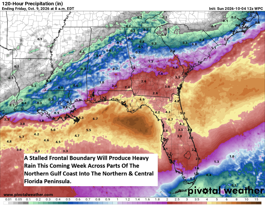
Even before this potential tropical system heads towards the northern Gulf Coast, that frontal boundary is likely to bring quite a bit of rain this week along the immediate coast of the northern Gulf coast as well as across the northern and central Florida Peninsula It does appear that the heaviest of the rain with amounts of 3 to 6 inches looks to occur this week across the Florida Panhandle and across northern and central parts of the Florida Peninsula. So, the additional heavy rain that may occur with this potential tropical system next weekend could lead to flood issues along the northern Gulf Coast.