


The very rough 2026 Hurricane Season for Hawaii is going to get even rougher by Friday into this weekend.
I wanted to cover the very real potential that the Big Island of Hawaii could be significantly impacted by yet another hurricane in just a couple of days from now.
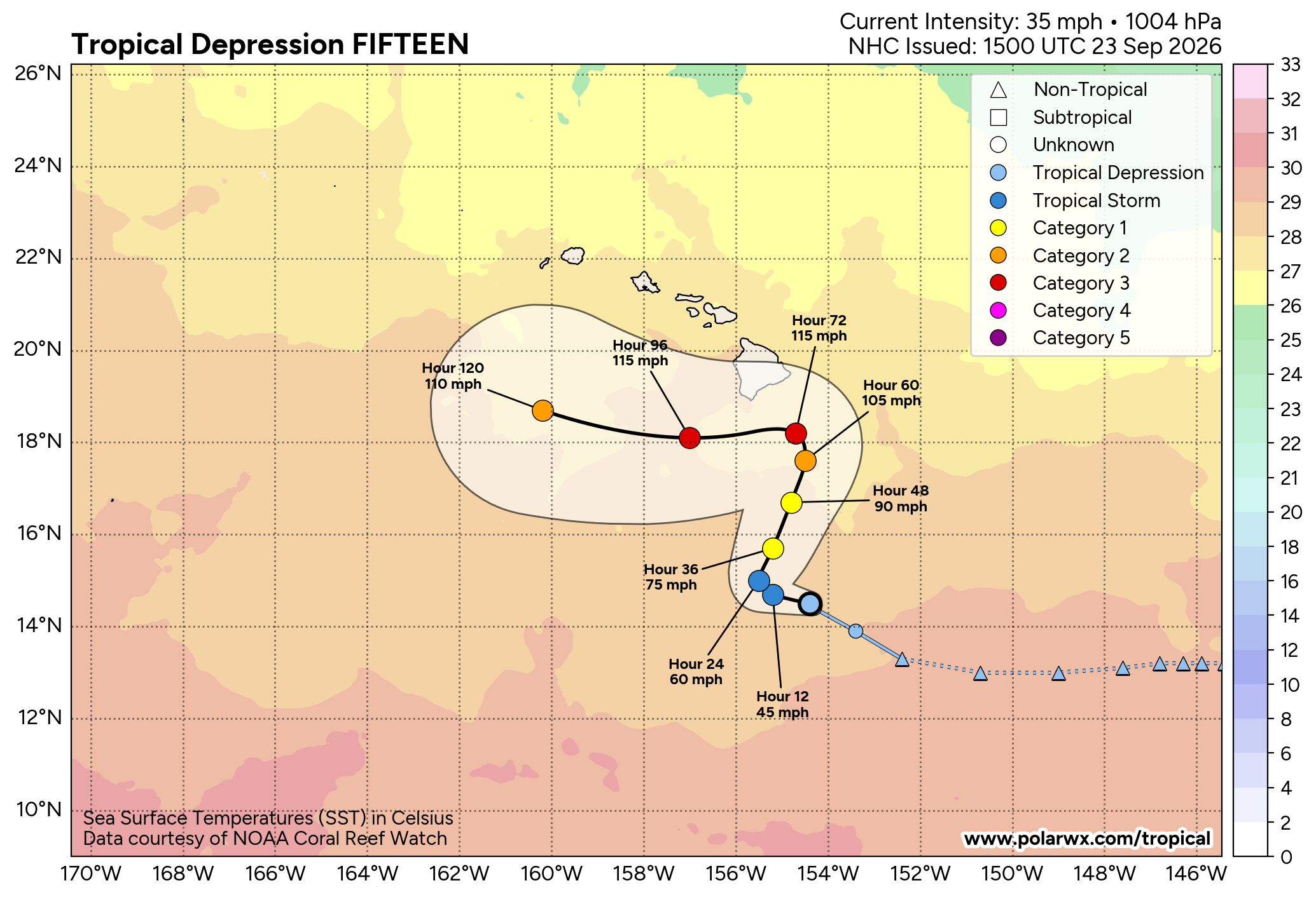
Tropical Depression Fifteen is currently located over the central Pacific about 400 miles or so to the south-southeast of the Big Island of Hawaii. It appears that a ridge of high pressure that’s located to the northeast of Hawaii will weaken and push to the east. Meanwhile, an upper-level trough of low pressure is expected to push into the western part of the Hawaiian Islands. This will cause this system to turn to the north and head for the Hawaiian Islands by Thursday.
It is also expected that this system will strengthen significantly over the next couple of days becoming a major hurricane by Friday. It is then anticipated that the core of our expected hurricane will either move very close to or move right over the Big Island of Hawaii by Friday night or Saturday.
It should be noted that there is a large amount of uncertainty as to how close the future major hurricane will get to the Big Island, but it could be close enough to bring some very significant impacts in terms of wind, surge and heavy rain by Friday and continuing into this weekend.
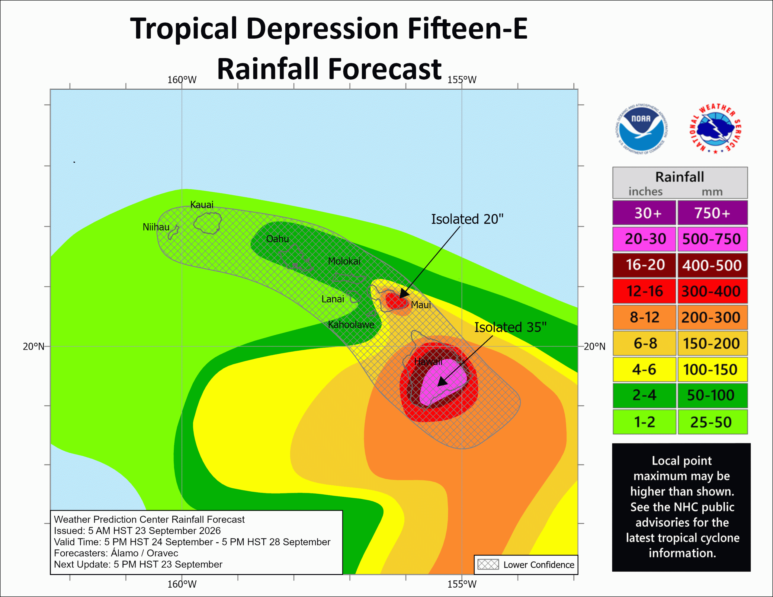
All residents and visitors to the Big Island need to start preparing now for very heavy rainfall amounts and the potential for major flooding. This heavy rain looks to begin on the Big Island as soon as Thursday and then continue through Friday and into this weekend. Catastrophic amounts of flooding and mudslides are looking quite likely for the Big Island & this is something that needs to be taken very seriously.
Additionally, residents and visitors to the Big Island need to be aware that hurricane conditions may impact parts of the Big Island by late Friday and then continue through Friday night and into Saturday. How strong the winds may get will depend on how close the core of the future hurricane gets to the Big Island.
Elsewhere: On the Atlantic side, the only item of any real importance right now is the expectation that a strong coastal low pressure system will bring heavy rain, strong winds, coastal flooding and beach erosion to areas from central and southern New England southward through the Mid-Atlantic states.
A non-tropical low pressure system is expected to strengthen significantly as it tracks offshore of the Mid-Atlantic coast from tonight through Thursday and Friday. This strong low pressure system is then expected to slow way down in forward speed and meander near the coast of southern New England during this weekend.
Coastal Flooding: The combination of persistent, strong onshore winds, high surf and higher than average astronomical high tides will lead to moderate to even major coastal flooding at the time of high tide along the Mid-Atlantic coast.
The worst of the coastal flooding is expected to occur during Thursday, Friday and Saturday across coastal Virginia, coastal Maryland, coastal Delaware & across southern New Jersey. Moderate to major coastal flooding looks very likely across these areas.
Further north, minor to possibly moderate coastal flooding at the time of high tide is expected over the next few days across all of coastal New England into Long Island and northern New Jersey.
Strong Winds & Heavy Rain: This storm is also expected to bring some strong winds with gusts of over 45-50 mph across the Mid-Atlantic coast during Thursday and Friday across the Mid-Atlantic coast.
Windy to very windy conditions are then expected across central and southern New England from Friday through this weekend. Wind gusts of over 50 mph are expected along the New England coast with wind gusts of up to 40 mph expected across inland sections of central and southern New England.
Additionally, heavy rain can be expected throughout this weekend across parts of central and southern New England. The higher rainfall totals closer to 2 to 4 inches or more will occur closer to the New England coast with lesser rainfall totals expected inland.