Hurricane Gabrielle: Gabrielle is rapidly strengthening today and it is now a major hurricane with 120 mph maximum winds.
Gabrielle is heading towards the north-northwest and it is fully expected that the hurricane will pass safely to the east of Bermuda later today. Beyond this, it is expected that Gabrielle will turn to the northeast and head out into the open Atlantic. In addition, it is expected that Gabrielle will continue to strengthen throughout the rest of today before it begins to weaken due to increasing amounts of wind shear and cooler ocean water temperatures.
Finally, it should be noted that the swells created by Gabrielle will affect Bermuda throughout the next few days. These swells will also affect areas of the US East Coast from the North Carolina coastline northward to the New England coastline over the next couple of days or so. These swells will lead to extremely rough surf and dangerous rip currents.
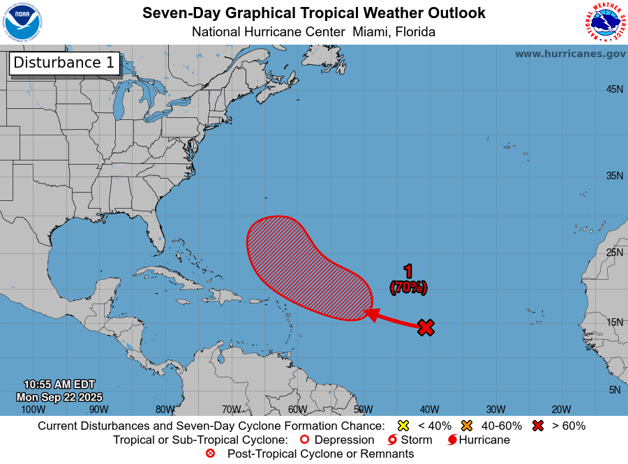
Area Of Disturbed Weather Located About 400 Miles To The East Of The Leeward Islands: Satellite imagery today indicates that there is a tropical wave that’s producing disorganized convection located just to the east of the Leeward Islands. This disturbance could be a system to really, really watch closely throughout this week for those of you in the Bahamas & along parts of the US East Coast from the Carolinas and points northward.
Analysis of the environmental conditions around this disturbance reveals that there is 30 knots of northerly wind shear affecting this system. This northerly wind shear is being produced by the outflow from Gabrielle & for now, these strong wind shear values will impede any sort of development. The environmental conditions may become more favorable for this disturbance to develop when it nears the Bahamas later this week.
A look at the model guidance reveals that while most of the models show this system reaching the Bahamas later this week, they have differing solutions on what might occur.
For instance, the GFS model has been pretty consistent in forecasting this system developing into a tropical system that impacts the southeastern Bahamas late this week. The GFS model then forecasts this system will head up the East Coast & directly impact the North Carolina Outer Banks next Monday before passing to the south of New England next Tuesday.
On the other hand, the European model forecasts this disturbance to struggle & not really develop at all. Instead, the European model forecasts that the disturbance that’s located to the east of this disturbance to develop instead.
As for the ensemble model guidance, the GFS ensemble model guidance has quite a few members showing development over or just east of the Bahamas late this week. From there, the GFS ensemble model guidance have many members showing a track just offshore of the US East Coast, but there are a few members that do show a direct impact to the North Carolina coastline & the Mid-Atlantic coast early next week.
The European ensemble model guidance has about 30-40 percent of its members forecasting development in the southeastern and eastern Bahamas on Friday into Saturday. From there, the European ensemble model guidance has most of its members keeping this system offshore of the East Coast of the US. That said, it does show a couple of members hinting at this system stalling just offshore of the Georgia and northeast Florida coast.
As for the Google Deep Mind AI model, a majority of its ensemble members show a developing tropical system in the Bahamas between Friday and Saturday. That said, there are a separate clustering of models that show this system developing in the Florida Straits. The clustering of models that forecast development in the Bahamas show a track northward that threatens areas from the North Carolina coastline northward to Southern New England. The other clustering of models that forecast development near the Florida Straits show a track into the eastern Gulf.
Here Are My Thoughts: I do think that we really need to keep a close eye on this particular disturbance as it could affect the Bahamas at the end of this week & then potentially get very close to some part of the East Coast of the United States.
While the conditions are currently unfavorable for development, these conditions do look a little more favorable for development near the Bahamas. Because of this, we could very well have a developing tropical system right in or very near the Bahamas at the end of this week.
As for the possible steering of this system. The upper level weather pattern near the East Coast of the United States this weekend into next week look to favor this system eventually turning to the north and northeast. The big question is how far west could this system get before it turns.
On one hand, it’s possible that a cutoff upper level low pressure system over the Southeastern United States could yank it quickly to the north and northeast leading it to brush the eastern Bahamas & then barely miss the East Coast of the United States.
On the other hand, it’s possible that this disturbance could be steered further to the west by the other tropical wave located further to the east. Should this occur, it could lead to this disturbance missing being pushed out by that upper level low & then meander near the Bahamas and the Southeast Coast of the United States early next week.
Given how high the uncertainty is with where this system might track & how strong it might get, I would closely keep an eye on it if you are in the Bahamas and anywhere from the Florida Peninsula through the Carolinas to the Mid-Atlantic States.
Finally, this disturbance is expected to bring some squally weather to the Leeward Islands & especially the northern Leeward Islands tonight through the day on Tuesday.
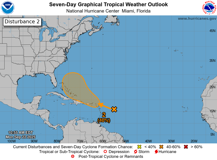
Area Of Disturbed Weather Located Halfway Between The Lesser Antilles & The West Coast Of Africa: The other disturbance to discuss today is currently located over the central Tropical Atlantic near about 40 West Longitude. This system seems to have a better chance of developing over the next few days as the environmental conditions are favorable. Fortunately, it looks fairly likely that this disturbance will stay to the north of the Lesser Antilles & not be a threat.
Looking beyond this, the model guidance all agree that this disturbance could move into an environment north of the Caribbean that is favorable for development. Because of this, we could have a tropical storm or a hurricane that tracks further west than what Gabrielle is currently tracking. This means that this particular disturbance could eventually become a threat to Bermuda around early next week.
As for the Bahamas and the East Coast of the United States, it currently looks as if an upper level trough over the western North Atlantic should steer this system away from the Bahamas and the US East Coast. That said, given the possible interaction with the other tropical wave, there is some uncertainty as to the final track of this system, but odds are that it should pass well east of the Bahamas and the US East Coast.
The next tropical weather discussion will be issued on Tuesday.