With the turn of the calendar page, we are now entering the active months of the Atlantic hurricane season (August, September & October) where a large majority of the activity and impacts occur. Right now, there are no areas that warrant immediate concern in terms of tropical development across the Atlantic, Caribbean and Gulf.
There are a couple of areas, however, that I continue to keep an eye on:
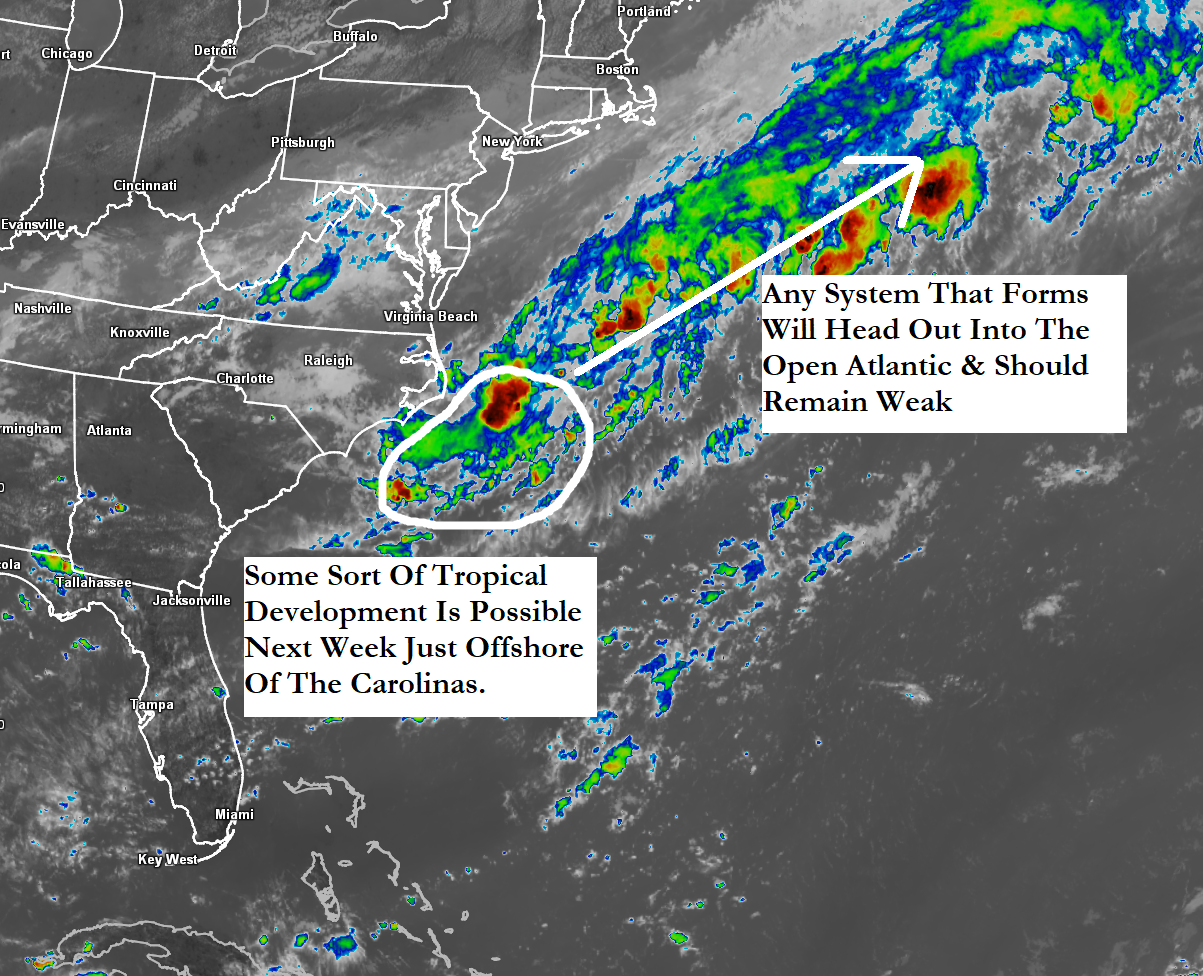
The First Area That I’m Watching Is near and offshore of the Carolinas where a stalled frontal system will remain in place throughout this weekend into next week. Along this front, it is expected that at least a couple of low pressure systems will form and head east-northeastward into the open Atlantic.
It is possible that some sort of development could occur with the low pressure system that forms just offshore of the North Carolina coast on Sunday and Monday and heads east-northeastward into the open Atlantic. Model guidance such as the GFS model, the Canadian model and the European model and their ensemble counterparts seem to show this system organizing just enough to perhaps become a depression as it heads out into the open Atlantic next week.
All-in-all, if any of the low pressure systems do become a depression next week as they head east-northeastward into the open Atlantic, they will not pose a threat to any land & they likely will remain fairly weak.
It is something that I am keeping an eye on and I’ll have updates as needed.
The Second Item That I’m Watching Closely Is the potential for a notable uptick in tropical development chances starting as soon as later next week and continuing through the week of August 11. This potential uptick in tropical development chances will coincide with the upward motion pulse of the Madden Julian Oscillation, which will be pushing into the Atlantic Basin starting next week and will remain in place through the middle and possibly later parts of this month. This upward motion pulse will allow for conditions to be more conducive for any westward moving tropical waves to develop.
Model guidance such as the GFS ensemble model guidance and the European ensemble model guidance seem to agree that a tropical wave pushing westward across the central and eastern Tropical Atlantic may try to develop into a tropical system later next week as it approaches the Leeward Islands. The ensemble model guidance then seems to point towards anything that forms may track near the Bahamas and the Southeast coast of the United States by around August 13.
The ensemble model guidance has the support of the Google Deep Mind AI weather model, which also suggests a tropical wave becoming a tropical system before it reaches the Leeward Islands later next week. The ensemble members of the AI model then seems to suggest any tropical system to head for an area somewhere between the eastern Gulf and the southeastern coast of the United States by about August 13.
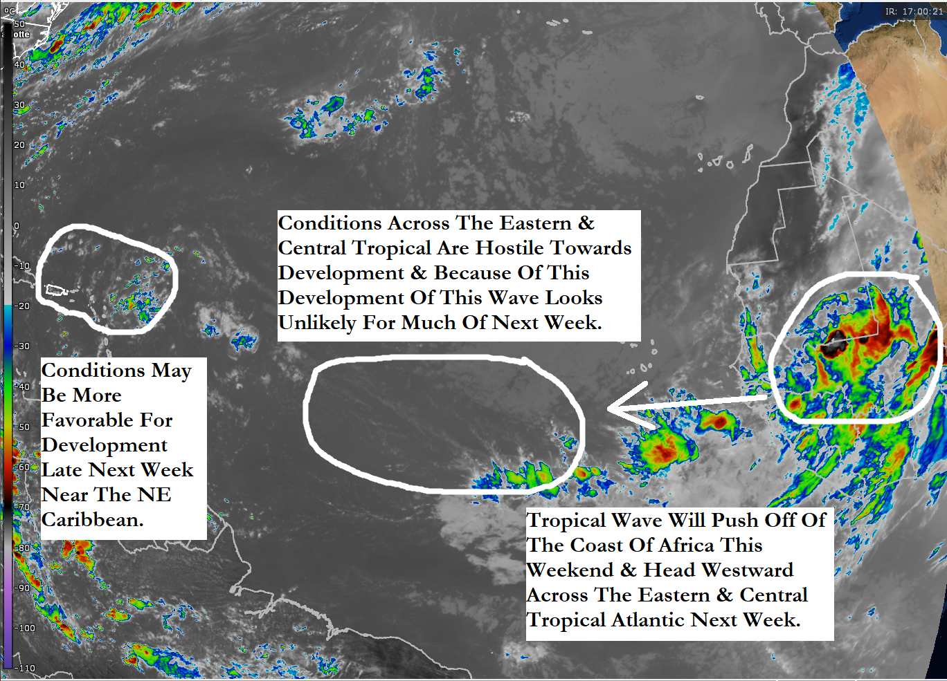
The tropical wave that the models are latching onto for potential tropical development later next week is currently located over western Africa. This wave is expected to push off of the coast of Africa into the far eastern Tropical Atlantic during this weekend and then head westward across the eastern and then central Tropical Atlantic during next week.
A look at the current environmental conditions across the eastern and central Tropical Atlantic reveals that the wind shear values aren’t all that favorable for development. There are strong amounts of wind shear found from about 40-45 West Longitude eastward to the coast of Africa. West of 45 West Longitude, the wind shear values do become more favorable for development and this is probably why the model guidance delay any sort of development until this wave approaches the Leeward Islands.
Here Are My Thoughts: I think that the tropical wave that’ll be pushing off of the African coast this weekend will certainly need to be watched closely as it heads westward across the eastern and central Tropical Atlantic next week.
Now I do think that this wave will struggle for a while due to sinking stable air and strong amounts of wind shear that’ll be found across the eastern and central Tropical Atlantic. These conditions may become more favorable near the Leeward Islands and because of this, tropical development may become a concern late next week into next weekend as this wave moves near or right over the Leeward Islands and the northeastern Caribbean.
Bottom line is that, I will be keeping a very close eye on this system next week as it heads westward from the coast of Africa to the Leeward Islands. That being said, I do think that the chances for development are quite low, probably less than 20 percent. The reason why is because I think the sinking stable air and strong wind shear may put quite a bite into this wave & even when the conditions become more favorable for development, there may not be much left of the wave to develop.
The next tropical weather discussion will be issued on Tuesday.