Low Pressure Located Near South Florida & The Northwestern Bahamas: I continue to keep an eye on a low pressure system that’s located in the area around South Florida & the northwestern Bahamas. Most of the convection that’s occurring with this low pressure system is just to the east of the eastern Bahamas.
A look at the environmental conditions around this low pressure system reveals that the wind shear values are far too strong to support any sort of development. Because of this, I do not expect any sort of development from this low pressure system as it slowly moves in the area from the northwestern Bahamas into South Florida over the next couple of days or so.
Interestingly, the latest ICON model, which did very well with Imelda, forecasts that a tropical storm will form over the southeastern Gulf very near southwest Florida late next week. While both the GFS and European deterministic models do not show this development, there are a couple of ensemble members that do show similar development over the southeastern Gulf late next week. The Google Deep Mind AI model also shows no development in the southeastern Gulf later next week. While I’ll certainly be keeping an eye on whatever low pressure systems that form near South Florida, I think that the development chances are very low.
The meandering low pressure system near South Florida this weekend will produce locally heavy rain across parts of Florida’s East Coast, especially as we get into Sunday, Monday and Tuesday. Areas along Florida’s East Coast from about Port Saint Lucie northward to Daytona looks to receive the heaviest rainfall amounts over the next few days with 2 to 5 inches of rain expected.
In addition, the weather setup over the Bahamas and Florida will likely lead to a persistent onshore wind flow to be in place for the next several days along Florida’s East Coast. Because of this, expect rip currents, rough surf and hazardous marine conditions all along Florida’s East Coast.
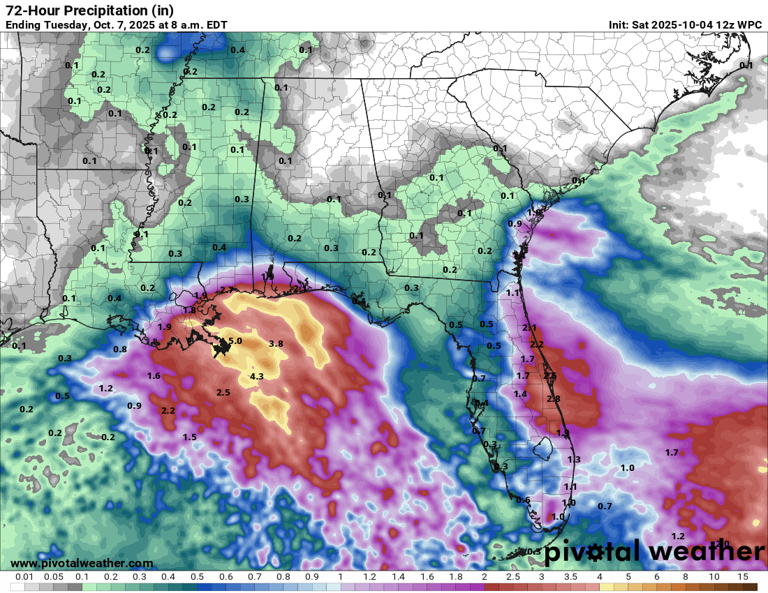
Low Pressure Located Over The North-Central Gulf: Weather analysis reveals that a weak low pressure system has formed over the north-central Gulf. This weather system is producing shower and thunderstorm activity across areas just offshore of the coasts of Louisiana, Mississippi, and Alabama.
The wind shear over the Gulf is far too strong to support any sort of development and because of this, tropical development is not expected.
This low pressure system will produce locally heavy rainfall across far southeastern parts of Louisiana, coastal Mississippi and coastal Alabama over the next couple of days. Rainfall totals of 2 to 4 inches are possible with even higher amounts offshore.
This low pressure system is anticipated to move onshore along the Texas coast by Monday.
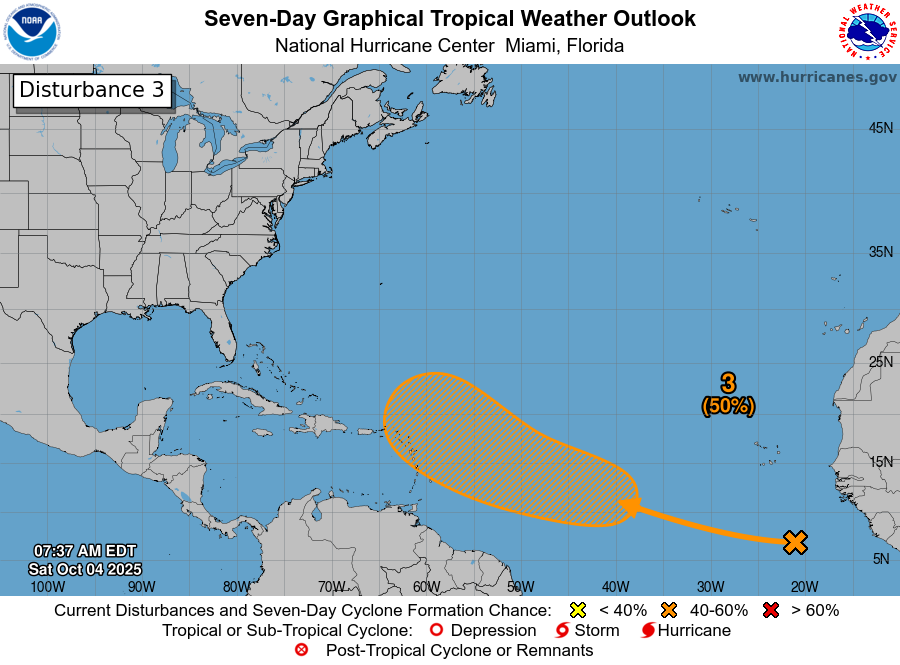
Tropical Development Continues To Be Possible Over The Central Tropical Atlantic During Next Week: A tropical wave is moving across the far eastern Tropical Atlantic today. This wave is producing a large area of disorganized shower and thunderstorm activity over the eastern Tropical Atlantic.
A look at the environmental conditions over the central and eastern tropical Atlantic reveals that the wind shear values are marginally favorable for development. This is due to strong wind shear found north of 15 North Latitude, but much lower wind shear values south of 15 North Latitude. This means that for this wave to develop, it’ll have to remain at a fairly low latitude. Also, there is dry air found between 35 and 45 West Longitude & this should inhibit any sort of quick development.
Based on my analysis, I think that we’ll probably see slow organization and development of this wave as it heads westward over the next several days. In fact, it’s not out of the realm of possibilities that this wave might wait until it’s west of 50 West Longitude to begin developing.
A look at the most recent model guidance reveals that the GFS model showing development occurring by the middle part of next week once this wave reaches 45 West Longitude. The GFS model then forecasts a very close pass to the northern Leeward Islands as a hurricane late next week.
The Canadian model shows even quicker development beginning near 40 West Longitude on Tuesday. The Canadian model then forecasts this system to miss the Leeward Islands to the east and northeast late next week.
The ICON model forecasts this system to be a monster hurricane and shows it to barely miss the Leeward Islands to the east and northeast late next week as a major hurricane.
Interestingly, the European model forecasts little or no development of this wave even when it gets close to the northern Leeward Islands late next week.
Even though there are a lot of models that do show development of this wave, I’m not quite sold on the idea due to the unfavorable or marginally favorable conditions I’ve already mentioned.
That said, my recommendation for those of you in the Lesser Antilles, Virgin Island and Puerto Rico is to still keep an eye on the progress of this wave. In particular, those of you in the northern Leeward Islands should keep especially close watch of this wave. While I do think tropical development of this wave looks slow to occur, it could still happen once it gets west of 50 West Longitude around Wednesday and Thursday. This means that this wave should reach the Leeward Islands around Friday, whether it develops or not.
The next tropical weather discussion will be issued on Monday.