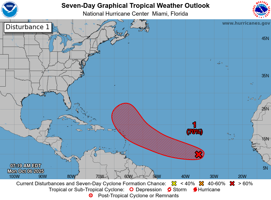
Invest 95-L Located Over The Central Tropical Atlantic: Satellite imagery and weather analysis reveals that Invest 95-L, which is located over the central Tropical Atlantic near 37 West Longitude, is producing a large area of convection. Most of this convection is disorganized, however, it does seem to look a bit better in the way of organization than it did yesterday.
A look at the environmental conditions around Invest 95-L reveals that the conditions aren’t all that favorable for development. The reason for this is due to west-northwesterly wind shear of 15 to 25 knots impacting this system. Additionally, there is dry air found on the western and northwestern sides of Invest 95-L.
A look at the model guidance reveals that many of them have backed off on their forecasts of how strong Invest 95-L might become. A majority of the guidance now seems to show Invest 95-L peaking at either tropical storm or Category 1 hurricane strength. Given the not so favorable environmental conditions that are affecting Invest 95-L, I don’t think we’ll see it become that strong.
At this point, I think that Invest 95-L will probably turn in time to just miss the northern Leeward Islands and northeastern Caribbean and because of this, it’ll be another grazing event for the northeastern Caribbean. Additionally, I do think that Invest 95-L will probably be anywhere between a 40 to 60 mph tropical storm as it passes just to the north of the northern Leeward Islands on Thursday night & it should be just far enough away to not bring tropical storm force winds to the Leeward Islands. That said, some rain squalls from the outer bands of this system could affect the far northern Leeward Islands on Thursday night.
For now though, those of you in the northern Leeward Islands should still keep an eye on Invest 95-L, just in case.
An East Coast Storm Is Quite Likely For This Weekend: Another area to keep a close eye on is the potential for a storm system to form off of the Southeast coast of the US around Friday night and Saturday. This storm system has the potential to become quite a weather maker along much of the Eastern Seaboard this weekend with heavy rain, gusty onshore winds, rough surf and coastal flooding all possible.
The weather setup leading to the formation of this notable storm system will be the combination of a cold front pushing off of the East Coast on Wednesday, low pressure forming near the Florida Keys and an upper level weather disturbance forming near the southeast coast of the US.
Given that this low pressure system will be moving northeastward and then northward from the tropical waters of the Florida Keys and the northern Bahamas, there is the possibility that it could be a sub-tropical or even a tropical system and this is something that’ll need to be watched closely. In fact, some of the model guidance are pointing to the idea that this storm system could be at least sub-tropical in nature & very possibly an actual tropical storm.
The potential impacts from this system could be fairly significant along the East Coast, whether it becomes a sub-tropical or tropical system or not. The coast of the Carolinas and the Mid-Atlantic states look to be hit very hard once again with gusty onshore winds gusting up to 50 mph, very rough surf and coastal flooding. We have already seen numerous homes get washed away in the Outer Banks as rough seas and erosion from other storms such as Erin, Humerto and Imelda. Another significant coastal storm would be very bad news & unfortunately, even more damage looks likely this weekend along the coastal Carolinas and the Mid-Atlantic.
Some of the impacts from this storm may push northward into areas from New York City through Long Island and into Southern New England by later Sunday and Monday. How significant these impacts are will depend on how far north the low pressure system moves & it is something to keep a close eye on.
I will be keeping a close eye on this potential weekend storm system & will have many more updates in the days to come.
The next tropical weather discussion will be issued on Tuesday.