


The big weather story this week is likely going to be the significant flooding that Hurricane Polo will produce across the Desert Southwestern US & across the I-35 corridor of Oklahoma and Texas.
Hurricane Polo is expected to move across the Baja during this afternoon and tonight and then move inland into northwestern Mexico during the day on Tuesday. It is then expected that Polo will push a ton of moisture into the Desert Southwest and then into Texas and the rest of the Southern Plains states. This will lead to the potential for significant amounts of rainfall & the very real likelihood of significant amounts of flooding.
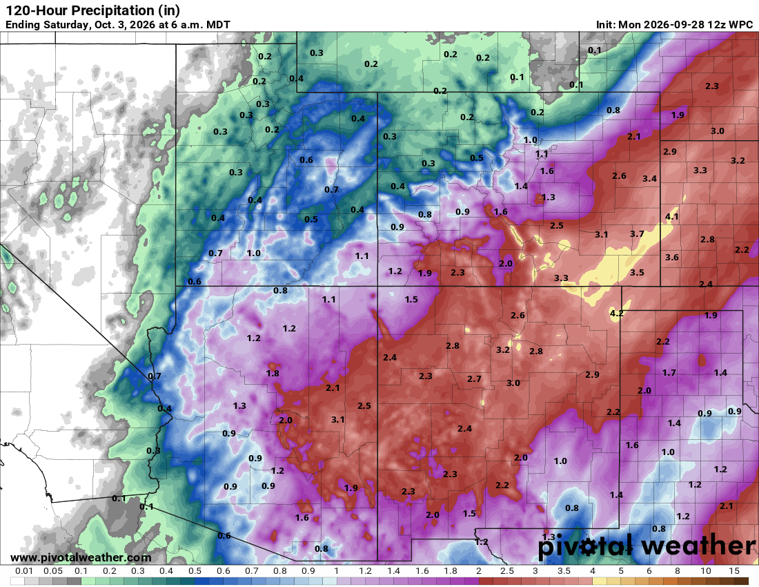
The first area of concern will be across eastern Arizona and across much of New Mexico where copious amounts of rain is already pushing into parts of Arizona. This heavy rain will expand across the rest of Arizona and across much of New Mexico during this afternoon and tonight. Heavy rain is then expected to continue through Tuesday, especially across eastern Arizona and across a large part of New Mexico.
Rain totals of 2 to 4 inches will be common across the eastern half of Arizona and across a large part of New Mexico. Local amounts of up to 4 to 6 inches are a strong possibility, especially across New Mexico. It should be noted that the Desert Southwest has already seen quite a bit of rain thus far this month & because of this, I have concerns that we are looking at a significant flood event for some areas. All interests across Arizona and New Mexico need to keep close tabs on this potential significant & very serious flood event.
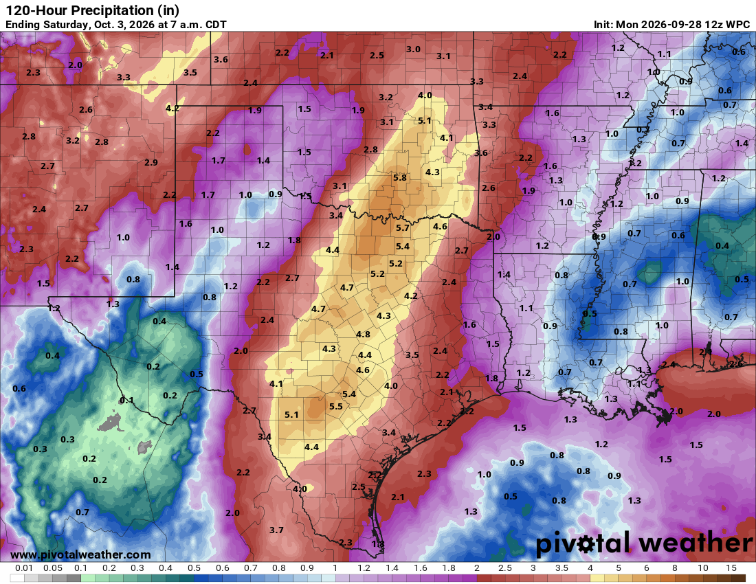
As For Oklahoma & Texas, Especially Along The I-35 Corridor: The moisture from Polo is expected to combine with a frontal boundary to produce repeating rounds of heavy rain from the Hill Country of Texas into North Texas and southern Oklahoma. The worst of the rain looks to occur during Wednesday and Thursday & it appears that the heaviest of the rain will be concentrated right near I-35.
Rain totals are expected to range between 4 and 8 inches from just south and southwest of San Antonio through Waco & Dallas and up to near Tulsa between Wednesday and Friday morning. It should be noted that locally much higher rainfall totals of up to 8 to 12 inches are a possibility somewhere along the Texas and Oklahoma parts of I-35.
Those of you in the Texas Hill Country and the Metroplex need to very closely monitor the weather forecasts surrounding the potential for very serious flooding.
Elsewhere: There are no areas of significant interest across the Atlantic, Caribbean or Gulf. Yes, we do have Invest 91-L that’s located well to the east-northeast of Bermuda, but this system poses no threat to any land areas, even if it does develop into a depression or tropical storm this week.
There are some signals in the data that suggest the southern Gulf or the area around the Yucatan Peninsula might be an area to watch for development between October 6 and October 12.
The reason why I’m watching this area is due to the fact that an area of low pressure might try to form near the tail end of a frontal boundary. Should this occur, we could possibly see some sort of development occur. That said, the chances for tropical development are, at most, 20 percent during this time period. Something to watch, but it’s definitely nothing to be concerned about.
Now, if we don’t see any sort of development next week, there’s the very real chance that we end this hurricane season with zero Atlantic hurricanes. It is expected that a strong sub-tropical jet stream will drop southward towards the Gulf over the next couple of weeks & this would likely end the hurricane season for the United States. We would then transition into what’s likely to be a very wet and very stormy winter along the Gulf Coast and across Florida.