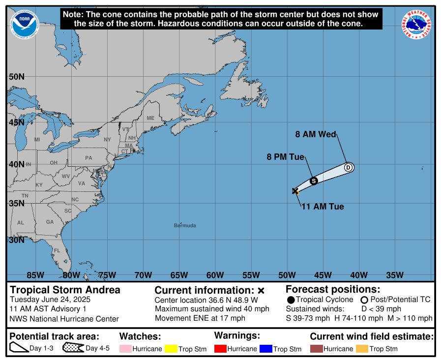
Today, we begin issuing our regular tropical weather discussions for the 2025 Atlantic Hurricane Season here at Crown Weather Services.
Current analysis reveals that there are no areas of immediate concern in terms of tropical development across the Atlantic, Caribbean and the Gulf.
Even though tropical development is not expected for at least the next few days, the model guidance has been occasionally hinting at the possibility of some sort of development to occur in an area between north of the Lesser Antilles westward to near the northern Bahamas and near the Southeast coast of the United States. This is something that the models have been hinting at for at least the last several days and I do think it is something that should be watched, just in case.
The most recent model guidance do show some very differing solutions. The GFS model and also the Canadian model currently shows a low pressure system forming well to the northeast of the Leeward Islands by early next week and moving westward to near the area halfway between the Bahamas and Bermuda by the middle and later parts of next week. It seems the European model also shows a similar idea, but is weaker with its forecast strength.
My take on this is that any low pressure system that forms between the Bahamas and north of the Leeward Islands next week should be quite weak in strength & probably will be non-tropical in nature.
Looking Beyond This – It seems the European ensemble model guidance is hinting at two areas that might need to be watched for possible tropical development chances near the end of this month.
The first area is in the southwestern and western Caribbean where the ensemble model guidance is showing upwards of a 30-40 percent chance for tropical development during the last week of this month. This matches the overall background pattern which seems to be pointing towards an upward motion pulse of the Madden Julian Oscillation to reach the Caribbean and the Atlantic during the second half of this month. This could lead to a favorable pattern for tropical development to occur in the Atlantic Basin.
A second area to possibly keep an eye on during the last week of May is right near the East Coast of the United States where the European ensemble model is showing upwards of 10-20 percent chance for tropical development during the last week of this month.
Interestingly, the CFS model does show an area of disturbed weather forming in the southeastern Bahamas right during the middle part of this month & then moving northeastward as a developing sub-tropical system to just west of Bermuda.
Bottom Line Is That while there might be some areas to keep an eye on, especially during the second half of this month, there is nothing that really stands out at me as a likely area for tropical development.
The next tropical weather discussion will be issued on Sunday.


