Things are expected to be quiet across the Atlantic, Caribbean and the Gulf throughout the rest of this week right through this weekend & no tropical development is expected.
As we get into next week, it appears that things are expected to become more stormy across the western and northwestern Caribbean. The reason for this storminess is due in part to a westward moving tropical wave that’s currently located over the central Tropical Atlantic near 48 West Longitude. It is expected that this tropical wave will reach the western Caribbean by about the early part of next week. The energy and moisture from this tropical wave is expected to combine with a favorable background state from an upward motion pulse of the Madden Julian Oscillation.
At first, this combination will probably produce stormy and squally weather across the western and northwestern Caribbean throughout next week. This squally weather may also affect western Cuba, the Cayman Islands, the Yucatan Peninsula and Belize during next week.
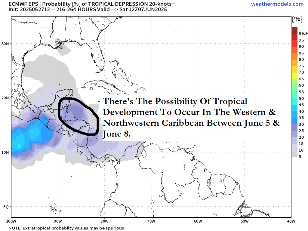
Eventually, we might see the development of a tropical system over the northwestern Caribbean between late next week and next weekend (between about June 5 and June 8). That said, this is not a sure thing, but it is a possibility and is something that does need to be watched.
Latest Model Guidance: There is a consensus in the model guidance that points to the possibility of tropical development occurring as soon as late next week.
The GFS model guidance is consistently showing the potential for tropical development to occur over the northwestern Caribbean as soon as late next week. The latest GFS model guidance continues to show this possible tropical development to occur in the northwestern Caribbean by next Friday and next Saturday. The GFS model then forecasts this tropical system to move into the southern and central Gulf by the following Monday and Tuesday (June 9 & 10).
The European model has been on and off with its forecast of tropical development. It does show a marked increase in stormy weather over the western and northwestern Caribbean to occur by next Tuesday and next Wednesday. The latest European model guidance forecast does show some minor tropical development to occur in the south-central Gulf around next Thursday and next Friday.
A look at the latest GFS ensemble reveals a marked increase in members that show tropical development in the northwestern Caribbean late next week. The GFS ensemble members then diverge with some members forecasting a track northwestward and westward towards the western Gulf while others show a track north or northeastward towards the eastern Gulf or towards Florida next weekend.
The European ensemble model guidance does show a few members forecasting development in the northwestern Caribbean very near the northeastern tip of the Yucatan Peninsula around Wednesday and Thursday of next week. Most of these model members forecast a track west-northwestward towards the western Gulf next weekend.
The European ensemble model guidance also shows a 25-30 percent chance for tropical development in the far western Caribbean very near the coasts of Belize and the Yucatan Peninsula later next week.
The latest European model weeklies is showing a 10-20 percent chance for a tropical storm to form between June 9 and June 15 in the southern and central Gulf.
Here Are My Thoughts As Of Late Tuesday Afternoon: I still think that the overall weather pattern for next week and the following week looks favorable for tropical development to occur in the western and the northwestern Caribbean. Whatever forms in the northwestern Caribbean would be pulled into the Gulf.
An upward motion pulse of the Madden Julian Oscillation is expected to push eastward into the Gulf and the Caribbean during the first half of June. This upward motion pulse promotes rising air and enhanced thunderstorm activity.
Right now, the environmental conditions across the Gulf and the Caribbean are highly unfavorable for tropical development. This is expected to reverse itself during the first week and more likely the second week of June as that upward motion pulse of the Madden Julian Oscillation causes the monsoon trough to be pushed northward leading to a favorable environment across the western Caribbean. While these favorable environmental conditions does not guarantee a tropical system will form, there will certainly be an opportunity for something to develop as soon as late next week over the western and northwestern Caribbean.
FYI – The first name on the 2025 list is Andrea.
This is something that still has my attention and is something that I will be keeping a close eye on.
The next tropical weather discussion will be issued on Friday.