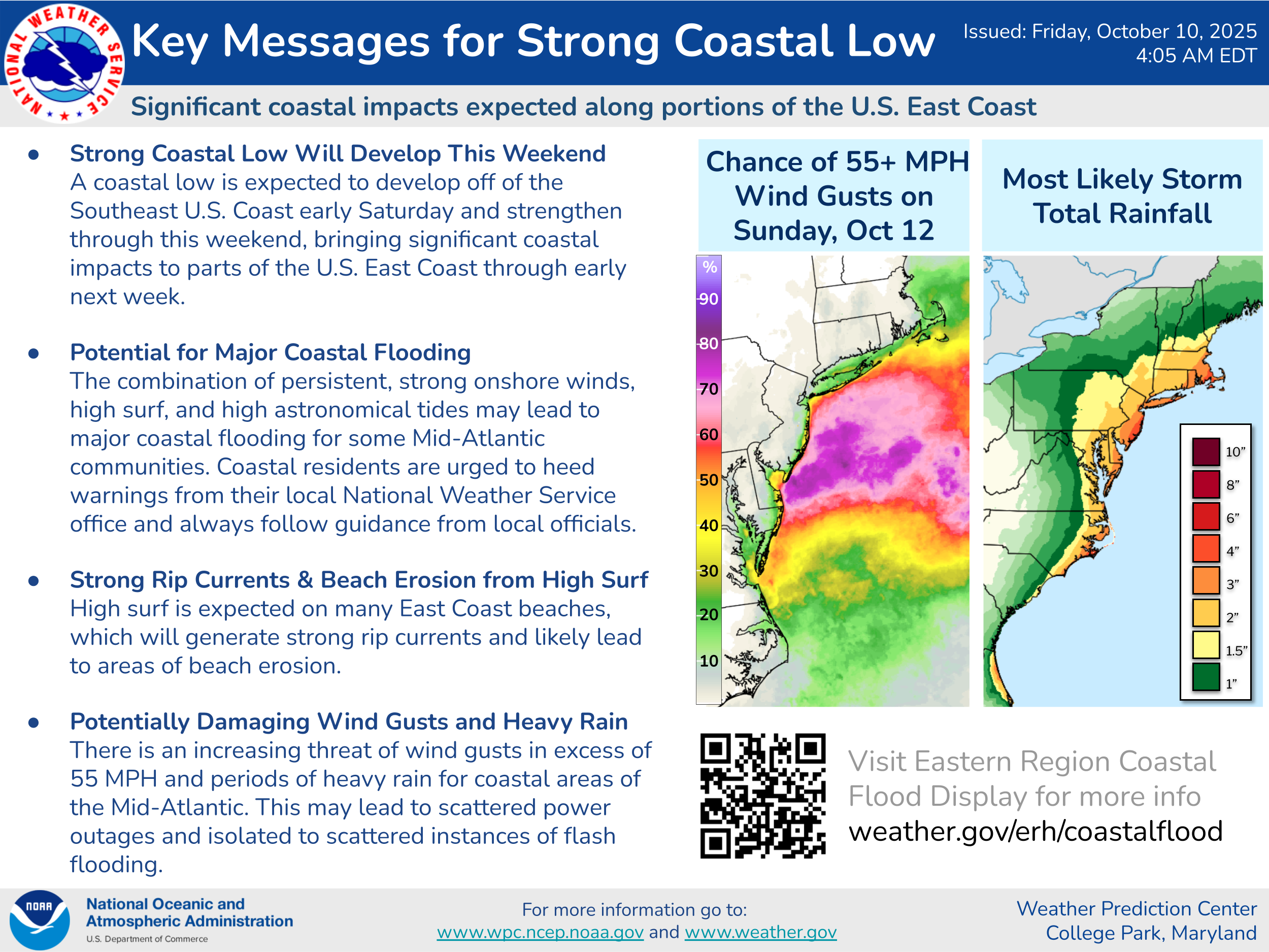
Very Significant East Coast Storm Expected This Weekend Into Early Next Week: Weather analysis today reveals that a low pressure system is forming offshore of Florida’s East Coast. This storm system is fully expected to bring very significant impacts to areas from Coastal North Carolina northward to Long Island and Southern New England this weekend into early next week.
It is expected that this storm system will lift northward over the next couple of days reaching the North Carolina Outer Banks on Sunday and then reaching the Jersey Shore on Monday. It is then anticipated that this storm system will stall briefly near the Jersey Shore before turning to the east and southeast and heading out away from land on Tuesday.
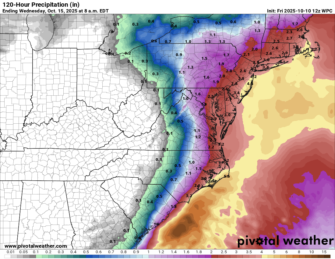
Significant impacts are expected from the North Carolina Outer Banks and the Tidewater of Virginia northward through the coastal parts of the Delmarva, coastal New Jersey, Long Island and Southern New England. What sort of impacts are we expecting? Several high tide cycles of moderate to major coastal flooding, waves of 15 to 20 feet, beach erosion, wind gusts of 50-60 mph and 1 to 3 inches of rainfall. The worst of these impacts are expected to occur on Sunday, Sunday night and Monday.
Looking first and foremost at the coastal flood threat –
For The North Carolina Outer Banks & Coastal Virginia: Moderate to possibly major coastal flooding is expected on Saturday night and Sunday. The high tide forecast for midday Sunday in Norfolk is expected to reach 6 feet, which is considered major coastal flooding. Also, the high tide forecast on the northern part of the North Carolina Outer Banks is also expected to reach 6 feet around midday Sunday, which is considered moderate coastal flooding.
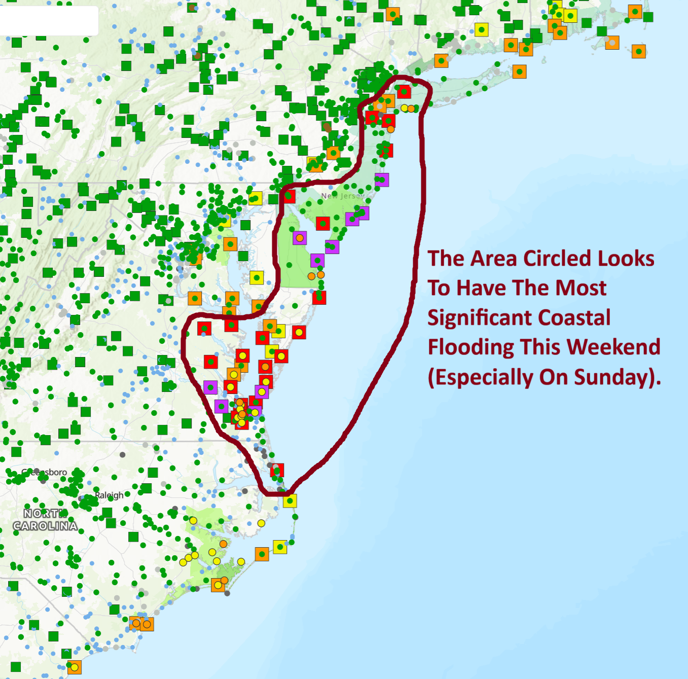
For The Delmarva Coastline & Coastal New Jersey: Some of the highest high tides since Hurricane Sandy and the January, 2016 Nor’Easter are expected during the day on Sunday. This means that major coastal flooding can be expected during Sunday’s high tide cycle all along the Jersey Shore into the Delmarva.
Atlantic City is expected to reach 8.2 feet during Sunday morning’s high tide cycle, which would be the highest since Hurricane Sandy.
The back bays in Jersey are likely to see the highest tides since the January, 2016 Nor’Easter. For Cape May, a high tide of 8.8 feet is expected, which would only be the second highest high tide on record with the first being 9.4 feet recorded during the January, 2016 Nor’Easter.
For Long Island & Southern New England: Since it appears that the strongest gradient with this storm system should stay just south of Southern New England, it appears that minor to moderate coastal flooding can be expected during the high tide cycles on Sunday and Monday.
By far though, the most severe coastal flooding impacts are likely to occur in the area from southern New Jersey into the Delmarva.
The winds with this coastal storm are likely to be quite strong. Wind gusts of 50-60 mph are likely from the North Carolina Outer Banks and the Virginia coastline northward through the Delmarva, the New Jersey coastline and into Long Island and coastal Southern New England. The strongest of these winds look to occur during Sunday, Sunday night and Monday.
In addition to the coastal flooding and strong winds, very rough surf can be expected that lasts for upwards of 48 hours. This will lead to significant beach erosion all along the coast from the North Carolina Outer Banks northward through the Delmarva, the Jersey Shore, Long Island & Southern New England.
Rainfall totals with this coastal storm look to average between 1 and 3 inches from eastern North Carolina northward through the Mid-Atlantic States into Southern New England. While this rainfall is not expected to be overly excessive, it could still produce some areas of flooding.
The Bottom Line Is That even though this storm system probably will remain non-tropical and not be considered a sub-tropical storm or a tropical storm, it will still bring some very significant coastal impacts, especially in the Delmarva and along the Jersey Shore. Because of this, please take this storm very seriously.
Tropical Storm Jerry: Jerry continues to be a disorganized mess as it now pulls away from the Leeward Islands. Even though Jerry is now moving away from the Leeward Islands, the “tail” behind Jerry will likely produce additional heavy rainfall across the Leeward Islands over the next couple of days. This additional heavy rainfall will produce some localized flooding.
Additionally, Jerry is still expected to stay far enough to the east of Bermuda to not be any sort of a threat to the island.
The next tropical weather discussion will be issued on Saturday.