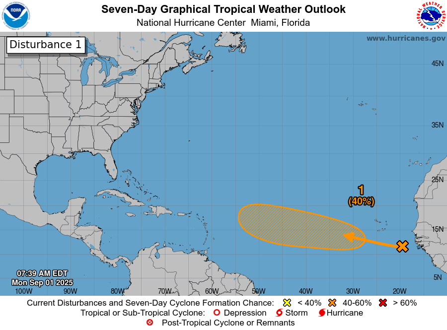
Tropical Wave Located Over The Far Eastern Tropical Atlantic: Satellite imagery and analysis of weather today revealed that there is a tropical wave located over the far eastern Tropical Atlantic along about 20 West Longitude. This wave is producing disorganized shower and thunderstorm activity with no signs of organization, at this time.
Analysis of environmental conditions reveals that there is a ribbon of low wind shear located about where the wave is positioned. There is, however, some strong wind shear located just to the north and just to the south of where this wave is located. Because of this, I think that the development of this wave will be slow to occur throughout this week. The reason why I think this is because if this wave does begin to ramp up and develop, it’ll build into the area of stronger shear & weaken as it runs into this stronger shear.
Looking further west, the environmental conditions become favorable for development west of about 45 West Longitude. This means that the development chances of this wave look to increase by the time the wave reaches the area west of 45 West Longitude some this weekend.
The latest model guidance continues to show very differing ideas on what might occur with this wave, depending on how much it develops this week & whether it turns to the north or not.
The GFS model continues to be the most aggressive of the models and forecasts quick strengthening later this week leading to this wave to be a hurricane by this weekend over the central Tropical Atlantic. This quick strengthening leads to this system to be influenced by a mid-Atlantic upper level trough & thus is pulled far enough north to miss the Lesser Antilles next week. Ultimately, the latest GFS model forecasts this system to be a significant threat to Bermuda and then to Atlantic Canada in about 2 weeks from now. Last night’s 00Z run of the GFS model was “entertaining” as it showed a highly improbable scenario of a northwest moving hurricane hitting eastern New England in a couple of weeks from now. No tropical storm or hurricane has ever hit New England from a southeast direction. They usually hit from the south or southwest.
The European model now barely develops this wave over the next 7-10 days & shows this wave affecting the Leeward Islands as a robust wave next Wednesday.
As for the ensemble guidance – The GFS ensemble model guidance continues to cluster around a scenario that keeps this system north of the Lesser Antilles around Tuesday or Wednesday of next week. in about 10 days from now. That said, there are a few members that do forecast an impact on the northeastern Caribbean in about 10-11 days from now.
The European ensemble model guidance continues to be further south in its members tracks of this wave. About half of the ensemble members continue to show an impact to the northeastern Caribbean around next Wednesday. The other half of the members of the European ensembles show a track that keeps this system to the north of the Lesser Antilles.
Here Are My Thoughts: For now, I don’t think this wave is anything to be concerned about or worried about for the next several days. I do think that any development of this wave will be very slow to occur & may not occur until the very end of this week or this weekend when it approaches and passes through the 45 West Longitude line.
Now, for those of you in the eastern and especially the northeastern Caribbean, I would keep an eye on this wave, but for now, any impacts are still at least 8-9 days away. In fact, it’s quite possible that this wave will end up passing north of the northeastern Caribbean & not be a concern. That being said, this wave is located at a pretty low latitude and it would take quite a strong upper level trough to really pull this system northward & miss the eastern Caribbean. Because of this, I think that there’s a slightly better than 50-50 chance that this system will be impacting some part of the eastern Caribbean (highest risk is for the northeastern Caribbean islands) around Tuesday or Wednesday of next week.
Looking further west, the weather pattern over the eastern United States into the western North Atlantic may continue to consist of a persistent upper level trough of low pressure for the next 1 to 2 weeks or so. This will put up a shield, of sorts, & deflect any tropical systems approaching from the east and southeast for the next 1 to possibly 2 weeks. More than likely, this wave will probably be pulled out into the open Atlantic once it gets past the 60-65 West Longitude line. That said, the weather pattern around mid-September could shift into a more ridging pattern over the eastern US & if this happens, it could try to draw this system towards the Bahamas and US East Coast, but for now, that has a very, very low chance of occurring.
Bottom line is that this wave poses no threat to any land throughout this upcoming week right through this weekend. It’s then possible that this system could become some sort of a threat to the islands of the eastern and especially the northeastern Caribbean around Tuesday or Wednesday of next week. There is, however, more than plenty of time to keep an eye on this wave.
The next tropical weather discussion will be issued on Wednesday.