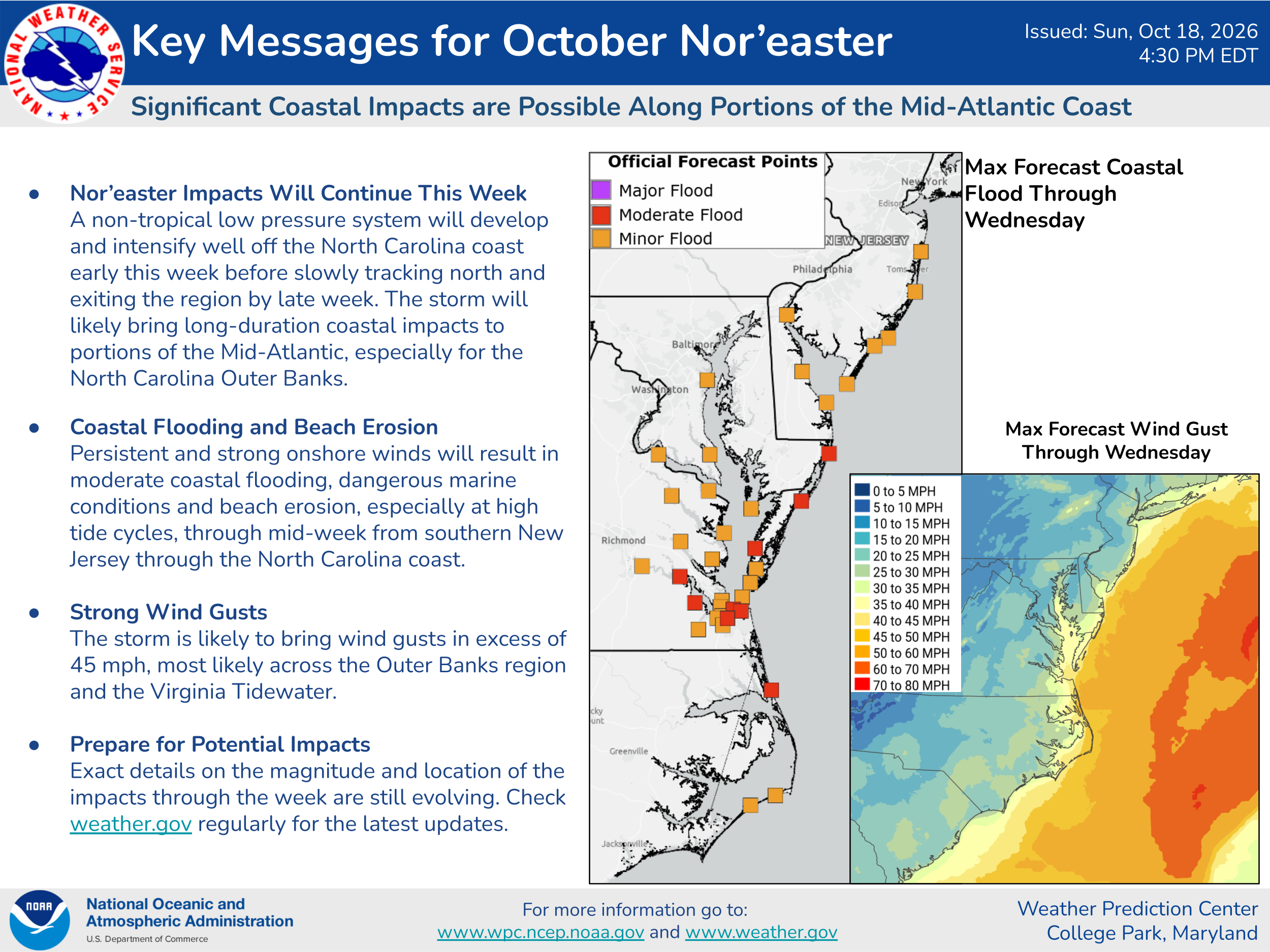


Current weather analysis today indicates that there is a non-tropical low pressure system that’s located off of the North Carolina coast near 33 North Latitude, 70.5 West Longitude. This storm system is expected to linger off of the North Carolina and Mid-Atlantic coastline throughout a good part of this week & there is a chance that it could transform into a sub-tropical storm or a tropical storm.
A look at the latest model guidance reveals that the Google Deep Mind ensemble model now shows a 30 percent chance that this low pressure system could become a tropical storm in the next couple of days. This is a decreased chance for development from this model as compared to what they were showing just a day or two ago.
The European ensemble model guidance seems to be showing a 50-60 percent chance for tropical development of this low pressure system offshore of the North Carolina and Mid-Atlantic coast during the middle and later parts of this week.
Here Are My Latest Thoughts: The impacts along the Mid-Atlantic and North Carolina coastline are expected to be the same, whether this low pressure system becomes a tropical storm or not.
These impacts are expected to include gusty onshore winds that will gust up to 40-50 mph, moderate amounts of coastal flooding, ocean overwash and beach erosion along the coastline from North Carolina’s Outer Banks through the Virginia Tidewater to southern New Jersey from today all the way until Thursday. It appears that the worst of the impacts over the next few days will occur along the northern North Carolina Outer Banks northward to Virginia Beach & Hampton Roads and along the lower Delmarva and Eastern Shore of Maryland.
Additionally, serious impacts in the way of coastal flooding and beach erosion is likely on Hatteras and Ocracoke Islands on North Carolina’s Outer Banks. Wave heights of up to 10 to 12 feet are expected to occur along the oceanside beaches in eastern Maryland and eastern and southeastern Virginia over the next few days.
I do still think that there is a fairly decent chance that this low pressure system will transform from a non-tropical storm into a tropical storm by about Wednesday or so. The reason why I think this is due to the fact that this low pressure system will sit nearly stationary offshore of the North Carolina coast putting it over the very warm waters of the Gulf Stream for the next 2 to 3 days or so. Because of this, I think that there is a better than 50 percent chance that the low pressure system will transform from a non-tropical storm into a 45-65 mph tropical storm in about 2-3 days or so from now.
All interests along the Mid-Atlantic and North Carolina coastlines should continue to monitor this storm system & its coastal impacts very closely.