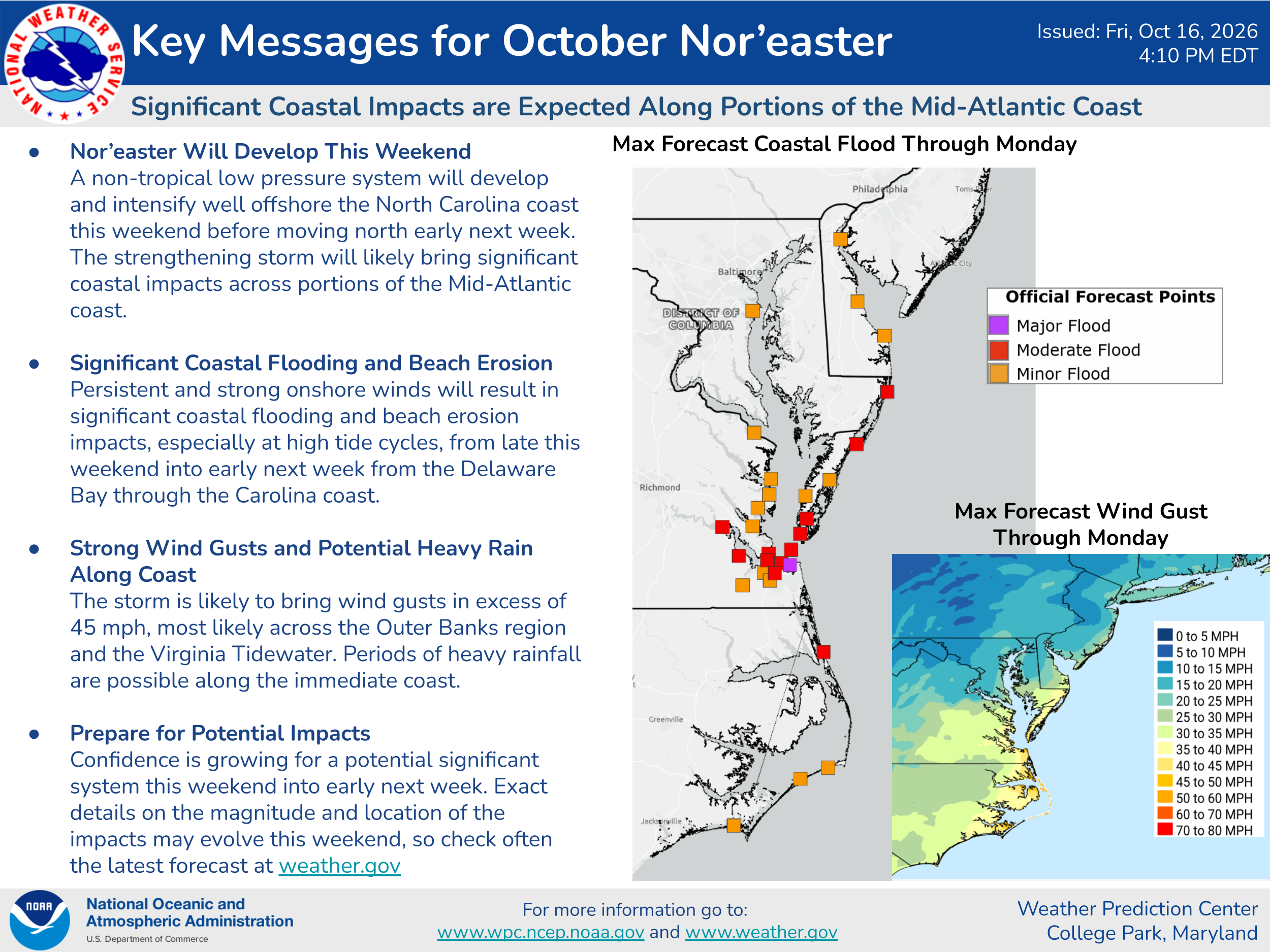


Weather analysis today reveals that an area of low pressure is developing offshore of the Mid-Atlantic coastline. It is expected that this low pressure will hang around near the Mid-Atlantic and North Carolina coastline for at least the next several days. The pressure gradient between this low pressure system and a big high pressure system over New England will produce some gusty onshore winds, large waves, beach erosion and coastal flooding along the entire Mid-Atlantic coastline and along the North Carolina coastline throughout this weekend through next week.
Additionally, it is quite possible that this low pressure system could transform from a non-tropical storm into a sub-tropical storm or even a tropical storm towards the middle part of next week.
A look at the most recent weather model guidance reveals that most of them are now showing this low pressure system to transform into a tropical storm near the North Carolina coastline by about the middle part of next week.
The Google Deep Mind ensemble model is now showing a 60 percent chance of this low pressure system becoming a tropical storm around the middle part of next week near the North Carolina coast.
The European ensemble model guidance now shows a 50-60 percent chance of this low pressure system becoming a tropical storm around the middle part of next week near the North Carolina coastline.
Here Are My Thoughts: It is fully expected that the pressure gradient between this low pressure system, which will sit just offshore of the North Carolina coast for several days, and a big high pressure system over New England will produce persistent gusty onshore winds with wind gusts of over 40 mph along the entire Mid-Atlantic coast from New Jersey to Virginia, as well as along the North Carolina coastline throughout this weekend right through all of next week. This will lead to prolonged coastal flooding and beach erosion this weekend through next week along the Mid-Atlantic and North Carolina coastline.
Now, I do think that there is fairly decent chance that this low pressure system will transform from a non-tropical storm into a tropical storm by about the middle part of next week. The reason why I think this is due to the fact that this low pressure system will sit nearly stationary near the North Carolina coast putting it over the very warm waters of the Gulf Stream for several days next week. Because of this, I think that there is a better than 60 percent chance that the low pressure system will transform from a non-tropical storm into a 45-65 mph tropical storm during the middle and later parts of next week. This will be something that I’ll be keeping close tabs on.
Either way, this storm system is fully expected to bring coastal issues from gusty onshore winds of over 40 mph in gusts to beach erosion and coastal flooding from coastal New Jersey southward to the coastline of North Carolina throughout this weekend & throughout next week. All interests along the Mid-Atlantic and North Carolina coastlines will need to continue to monitor this storm system very closely.