


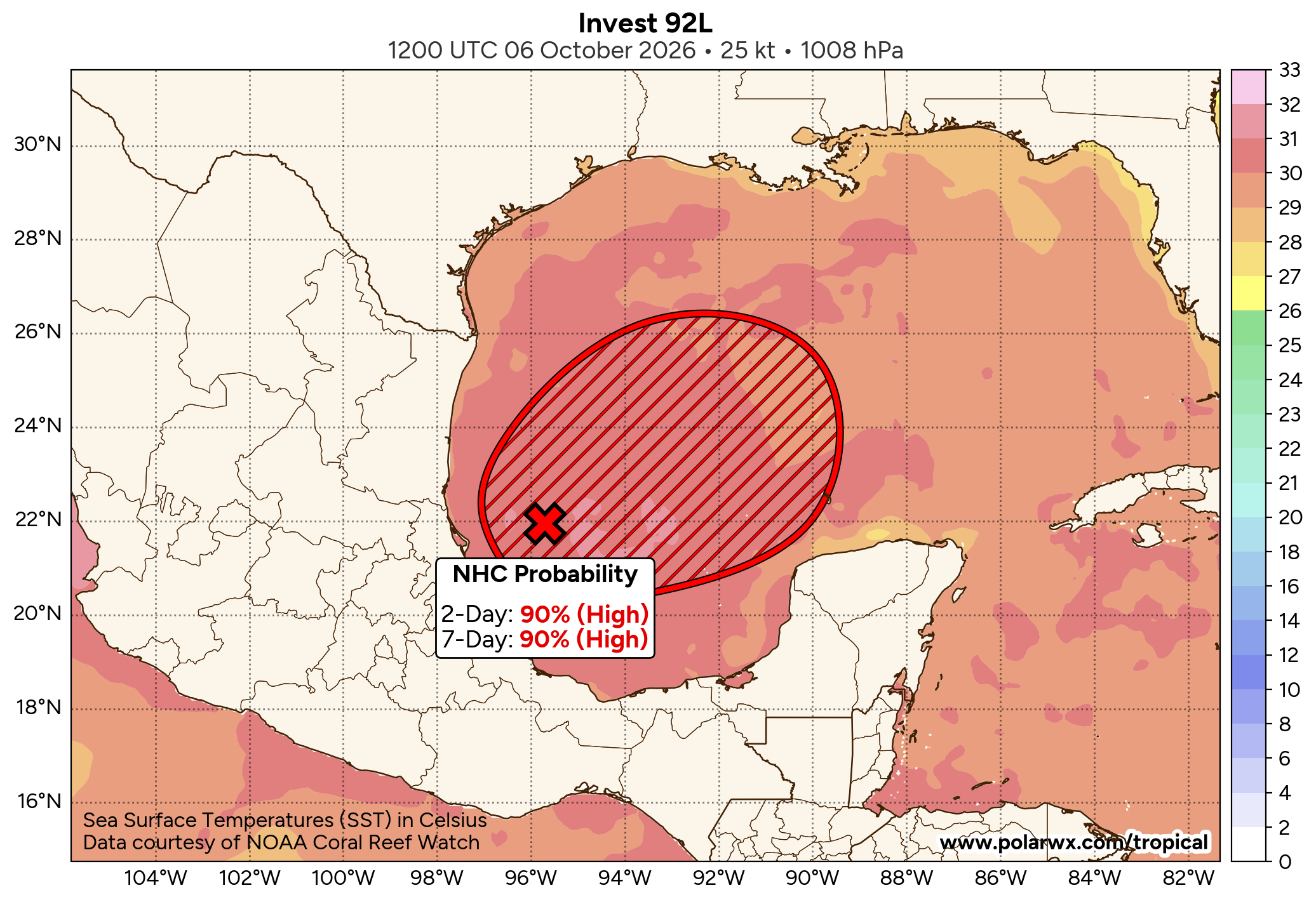
Invest 92-L Located Over The Southwestern Gulf: Invest 92-L, which is located in the southwestern Gulf, is very clearly organizing today. Satellite imagery indicates that there is robust convection occurring with this system & it appears that the convection is organizing.
Today and tomorrow is going to be important in terms of how much Invest 92-L organizes. The quicker this system organizes and strengthens over the next 24-36 hours, the further east it’ll track putting it in a more favorable environment for strengthening. It also would mean Invest 92-L would head for the Alabama coastline and the Florida Panhandle instead of further west towards coastal Mississippi or coastal Louisiana.
A look at the environmental conditions around Invest 92-L indicate a favorable environment for development and strengthening. This includes wind shear values of 10-20 knots, some extremely warm Gulf waters, an established low pressure system & plenty of upper-level divergence. To me, this says to me that Invest 92-L will very likely become a tropical storm as soon as late Wednesday or Thursday. It is then possible that this system could become a hurricane by Friday just before it heads for the northern Gulf coast.
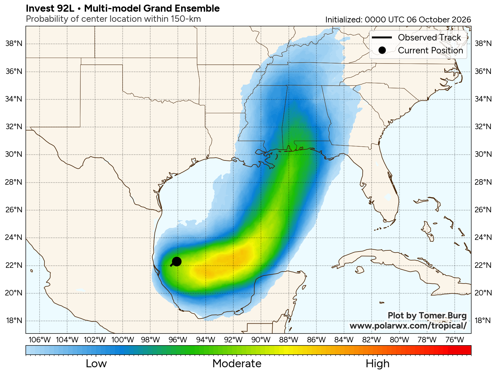
A Look At The Latest Model Guidance reveals that guidance such as the Google Deep Mind model and the European AIFS model are showing a stronger system heading towards the Alabama coastline or the Florida Panhandle with a landfall on Friday night. Also, a large majority of the ensemble members do show it being a hurricane at landfall.
On the other hand, models such as the GFS model and the European model show a weaker system which travels slowly northward in a much more hostile environment. This would lead this system to be, at most, a very sloppy and wet tropical storm & come ashore in southern Louisiana and southern Mississippi on Sunday.
One thing to note about these two model guidance scenarios is that the faster this system travels in the Gulf, the less wind shear it’ll feel & the stronger it could be at landfall. Also, a faster moving system would head for the Florida Panhandle or southern Alabama while a slower moving system would head for southern Louisiana or southern Mississippi.
Here Are My Thoughts: I do think that it is extremely likely that Invest 92-L will end up being our next tropical storm of the season. I expect it to probably become a tropical storm as soon as late Wednesday or during Thursday.
I suspect that for the next 2-3 days or so, we’ll see this system slowly move towards the east or northeast over the southern Gulf, all while organizing and strengthening. This means that we probably will have a strengthening tropical storm or maybe even a low-end hurricane over the southern Gulf by the time we get into Friday.
As we move through the day on Friday, this system is likely to speed up in its forward motion and head towards the northern Gulf coast. This is due to the likelihood of an upper-level trough of low pressure that’ll be located over the western Gulf to pick it up and send it towards the north or northeast and for the northern Gulf coast.
The question then becomes how fast will this system be moving when it’s headed for the northern Gulf coast. A faster moving system would likely be steered more towards the northeast and head for southern Alabama or the Florida Panhandle. Also, a faster moving system would end up probably making landfall as a upper-end tropical storm or even a low-end hurricane on Friday night. Meanwhile, a slower moving system would end up being steered more towards the north and head for southern Louisiana or southern Mississippi. Also, a slower moving system would be significantly impacted by some very strong wind shear over the northern Gulf & would probably come in as a very weak tropical storm, at most.
Given that Invest 92-L seems to be already organizing fairly quickly, I think the idea of it heading quickly towards southern Alabama or the Florida Panhandle seems most possible right now. While I think this system may end up becoming a hurricane at some point on Friday, I do think it may end up weakening a bit just before landfall leading it to be a tropical storm when it comes ashore on the Florida Panhandle or across southern Alabama.
For Those Of You Along The Northern Gulf Coast From Louisiana To The Florida Panhandle – While the exact details on how this system will impact the northern Gulf coast still need to be figured out, I think there is the very real possibility for a moderate to strong tropical storm to come ashore by Friday night or Saturday morning. I urge everyone from Louisiana to the Florida Panhandle to check back often for the latest updates.
I do think that the biggest hazard from this system will probably be heavy rain and the threat for flooding along the northern Gulf coast from southern Louisiana through the Florida Panhandle. Additional rainfall totals of 4 to 8 inches are likely, especially during later this week into the holiday weekend. Isolated rain totals of 10 inches or more are a possibility over the western Florida Panhandle.
The next potential hazard from this system will be coastal flooding and the possibility for tropical storm force winds across a large part of the central and eastern Gulf coast. The higher coastal flood and wind threats from this system would potentially occur on the eastern side of it. This means that areas from southern Alabama and the Florida Panhandle to the west coast of Florida may end up seeing the worst of the weather from this system, even if it’s weakening at landfall. This could include a storm surge of up to 6 feet and winds that gust up to at least 60 mph at times during Friday into Saturday.
Finally, there will very likely be the potential for tornadoes on Friday into Saturday across areas to the east of where this system makes landfall. This means that possibly the Panhandle of Florida and parts of the central and northern Florida Peninsula may have a potential for tornadoes on Friday into Saturday.
The Bottom Line Is That there is the likelihood of a tropical storm or perhaps even a hurricane approaching the northern Gulf coast between Louisiana and the Florida Panhandle by Friday into Saturday. It’s still too soon to tell exactly how strong this system will be as it heads for the Gulf coast, but at this point I think we’re looking at either a tropical storm or a low-end hurricane at landfall.
As I already mentoned, heavy rain and flooding looks to be the big threat with this system, especially along and to the east of where this system makes landfall. The heaviest rain looks to get started along the northern Gulf coast as soon as Friday and continue into the weekend. Heavy rain is also likely to extend inland into much of the southeastern United States throughout this weekend.
I will be keeping very close tabs on the progress of Invest 92-L and will have many more updates as needed.