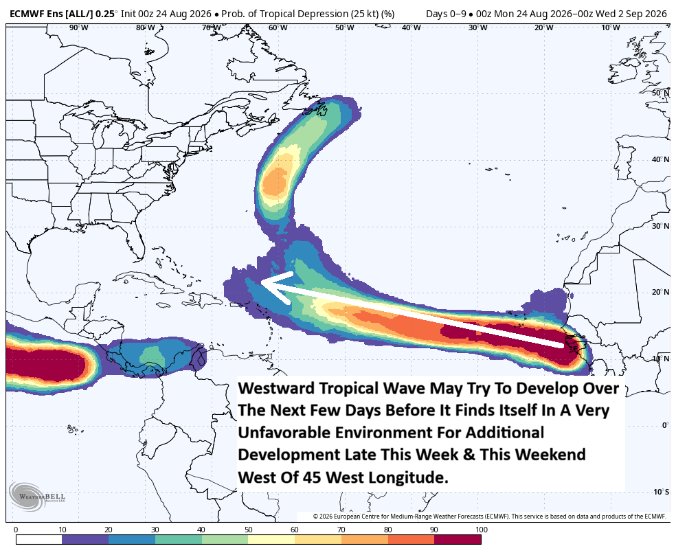


Satellite imagery and weather data reveals that a strong tropical wave has just pushed off of the west coast of Africa. This tropical wave is producing a smattering of shower and thunderstorm activity & it appears that a low pressure system is attached to the wave. This is the wave that will need to be watched closely for the potential of tropical development throughout this week through probably this weekend into next week. It does appear that we will be tracking this tropical wave for many days to come.
Analysis of the environmental conditions around this tropical wave reveals that while the wind shear values are favorable for development, it appears that there is some dry air located to the north and west of the wave. This says to me that the conditions are favorable enough to support some development over the next few days. By the very end of this week and this weekend, it appears that this wave may run into some strong amounts of wind shear once it crosses the 45 West Longitude line. When this happens, then we’ll probably see the end of this wave developing any further, for now.
A look at the various model guidance reveals that some guidance such as the GFS model and the European model being fairly aggressive with their forecasts of development during this week as this wave tracks westward across the eastern and central Tropical Atlantic. Other model guidance such as the Google Deep Mind ensemble guidance and the European AIFS ensemble guidance seems to show some development over the next couple of days before those development chances drop dramatically by this weekend as the wave reaches that more unfavorable environment. It should be noted though that these two ensemble AI models then show an increase in development chances next week when this system reaches the southwestern North Atlantic in an area near or to the east of the Bahamas. This increase in the development chances next week in the southwestern North Atlantic is due to the potential for this wave to find itself in a much more favorable environment for development.
My Thinking Is That I’m not really anticipating to see a whole lot of development from this tropical wave throughout this week as it heads westward across the eastern and central Tropical Atlantic. While some development is a possibility over the next 3-4 days due to the relatively favorable environmental conditions, those chances for development are likely to drop to near zero by the very end of this week and this weekend. This is because the tropical wave will run into some strong wind shear once it reaches about 45 West Longitude.
If this tropical wave survives the strong wind shear environment in the tropical Atlantic during this weekend into early next week, then it could find itself in a more favorable environment for not only development, but also for strengthening over the southwestern North Atlantic during the middle and later parts of next week. This will be something to keep an eye on, especially once we approach next week.
For now though, this tropical wave is nothing to be concerned or worried about. More than likely, this wave will pass far enough north of the Lesser Antilles and the eastern Caribbean to not be a concern early next week. Also, we are more than a week away from this wave possibly reaching the southwestern North Atlantic where it might find itself in a more favorable environment for development. Because of this, there is more than enough time to keep track of this wave.