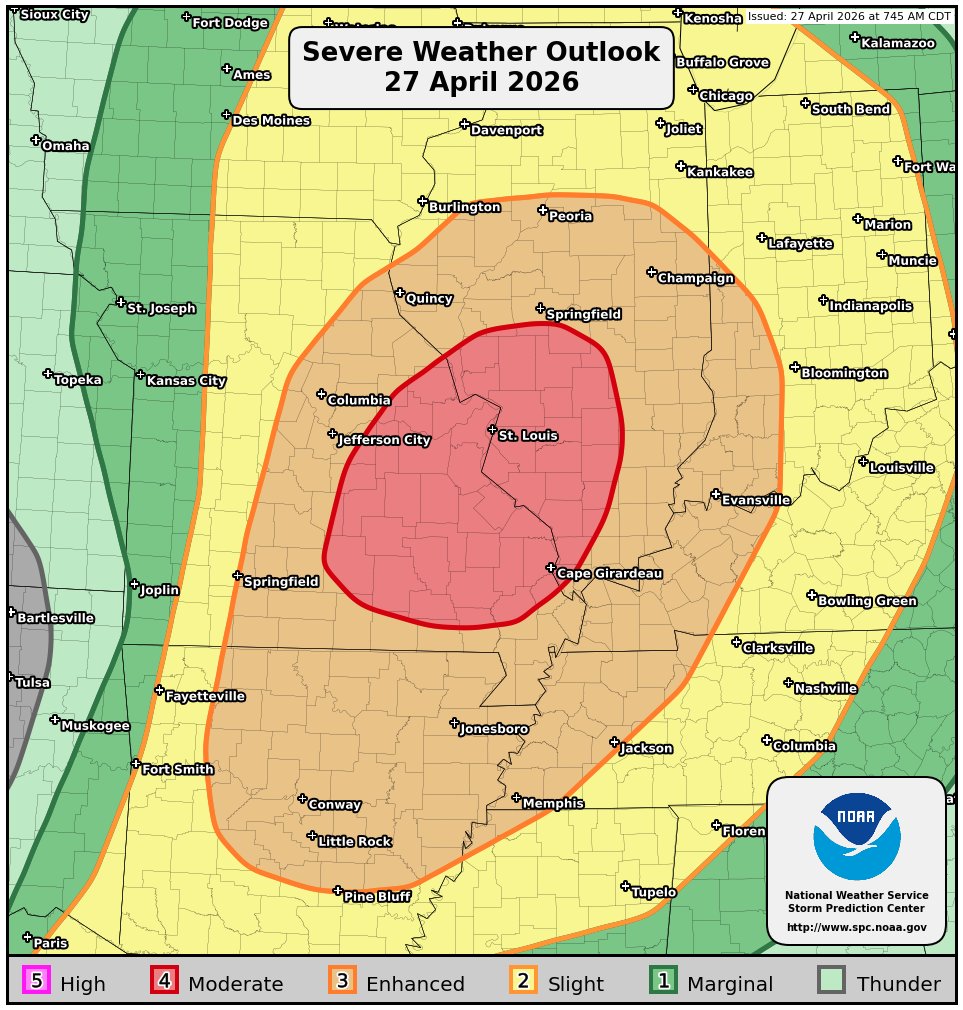
Summary: Numerous severe thunderstorms are expected in the area from the middle Mississippi Valley through the lower Ohio Valley and into the Mid-South this afternoon and this evening. Multiple strong to violent tornadoes of EF-3 or more in strength, widespread damaging winds and large to very large hail is expected, especially across eastern Missouri, northeastern Arkansas, central and southern Illinois, western Kentucky and northwestern Tennessee.
Details: A very active severe weather afternoon and evening is expected across much of the middle Mississippi Valley, the lower Ohio Valley and the Mid-South. It appears likely that there will be a corridor for intense supercells with strong to violent tornadoes this afternoon and this evening across eastern Missouri and central and especially southern Illinois.
NOTE – I do have significant concerns that the St. Louis metro may be at extreme risk for tornadoes late this afternoon and early this evening between about 4 pm CDT and 8 pm CDT.
An upper-level trough of low pressure is expected to push northeastward from the central and northern Plains states into the Midwestern US this afternoon and tonight. In response to this, it is expected that a surface low pressure system will develop across Wisconsin and Minnesota by this evening with a warm front stretching across the Midwestern US. It is likely that a very unstable and strongly sheared air mass will be in place during this afternoon across central and eastern Missouri into southern Illinois, the lower Mississippi Valley and the Mid-South.
Supercell severe thunderstorms are expected to develop between about 2 and 4 pm CDT across the middle Mississippi Valley and the Mid-South. These supercells will exist in a very favorable environment for tornadoes and multiple strong to violent tornadoes of EF-3 or more in strength are likely across eastern Missouri and central and especially southern Illinois.
It appears that eastern Missouri, including the St. Louis metro may be at extreme risk for tornadoes between about 4 pm CDT and 8 pm CDT. Southern Illinois may then be at extreme risk for tornadoes between about 5 pm CDT and 10 pm CDT.
As we get into the overnight hours of tonight, it is expected that these supercells will evolve into clusters of severe storms capable of producing widespread damaging winds across the middle Mississippi Valley and the lower Ohio Valley.