Analysis today reveals that there is a pretty robust tropical wave that’s located over the eastern Tropical Atlantic near 25 West Longitude. Even though this wave looks pretty robust, water vapor satellite imagery shows that there is dry air located to the north of the wave. Additionally, there seems to be some unfavorable wind shear values waiting for this wave over the Tropical Atlantic, between about 45 West Longitude to about 60 West Longitude. Because of this, no tropical development of this wave is expected for at least the next several days as it heads westward.
This tropical wave is expected to reach the Windward Islands and the eastern Caribbean around late this weekend and early next week and then reach the central Caribbean towards Tuesday and Wednesday of next week.
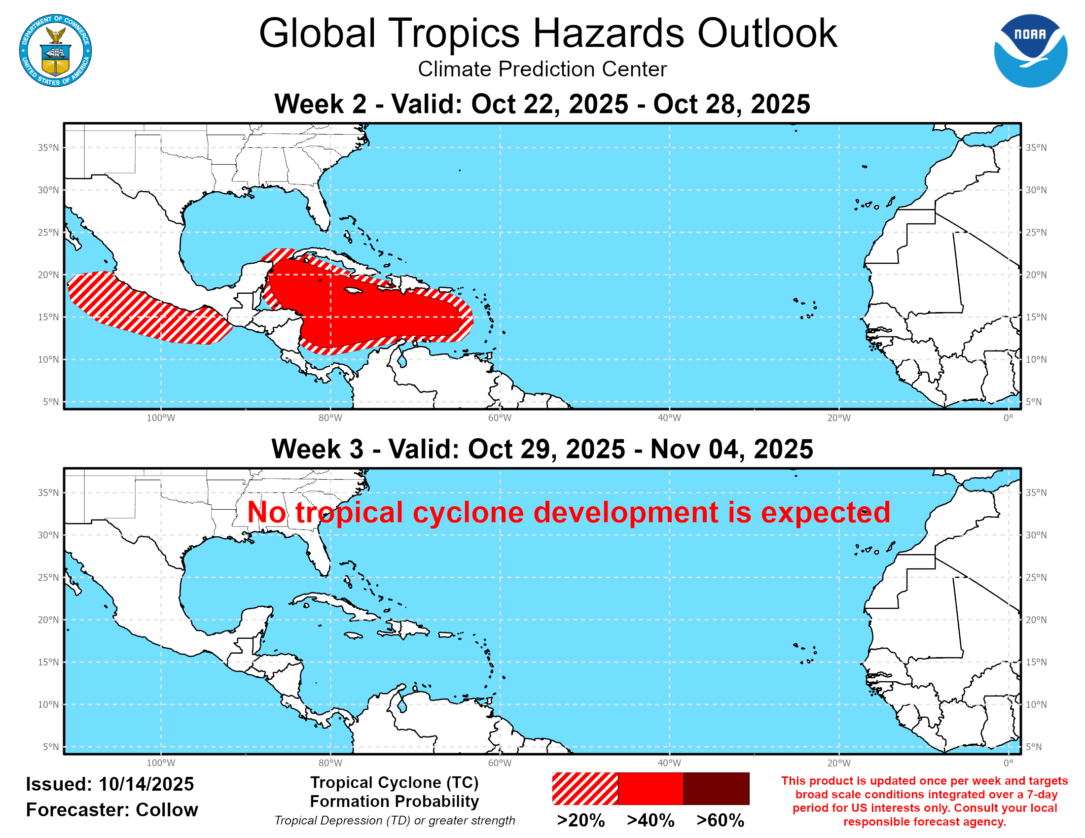
The chances for this wave to develop are expected to increase quite a bit once it reaches the western Caribbean late next week. The reason for this is that the environmental conditions are expected to be favorable for development over the western Caribbean leading to this wave potentially developing as we get into late next week and next weekend.
While the signal for western Caribbean tropical development in the model guidance has increased a little since yesterday, it is far from certain as to whether tropical development will actually occur or if this will end up being a wave that just quietly heads westward across the Caribbean with no development at all. That being said, there is definitely a model signal for western Caribbean tropical development & very possibly significant tropical development late next week and next weekend & it is definitely something that’ll need to be watched closely.
In addition, the various model guidance members, including the GFS ensemble, the European ensemble & the Google Deep Mind AI ensemble models do disagree on where any tropical system that develops might go. Some guidance members show any system remaining in the western Caribbean and eventually heading for Central America, Belize and the Yucatan Peninsula. Other guidance members point to the possibility of a Eastern US upper level trough pulling this system northward out of the Caribbean and towards Cuba, the Bahamas & the East Coast of the United States.
The reason for the track difference in the ensemble members seems to have to do with the strength of the storm. The ensemble members that show this system headed westward towards Central America forecast a weak system. Meanwhile, the ensemble members that forecast this system becoming a strong tropical system show it being yanked northward out of the western Caribbean.
As I mentioned yesterday, it is way too soon to try to figure out which track and strength scenario might occur with this wave.
On one hand, the environmental conditions are forecast to be favorable and possibly very favorable for this wave to become a significant to very significant hurricane in the western Caribbean. Because of this, it would probably be influenced by that Eastern US trough and be pulled northward out of the Caribbean and towards Cuba, the Bahamas and the East Cost of the United States.
On the other hand, there’s an equal chance that this wave may end up staying weak & not take advantage of the favorable environmental conditions. Should this occur, it would miss that trough and head westward into Central America with no development at all.
I want to emphasize that while this tropical wave certainly needs to be watched very closely, there’s no telling yet of where it might ultimately go, should it go. There’s also no telling as to how strong it might get.
This means that you shouldn’t be overly concerned or worried about this wave, yet. I would, however, keep a close eye on this wave if you are in the western Caribbean as there is plenty of time to keep an eye on it.
The next tropical weather discussion will be issued on Friday.