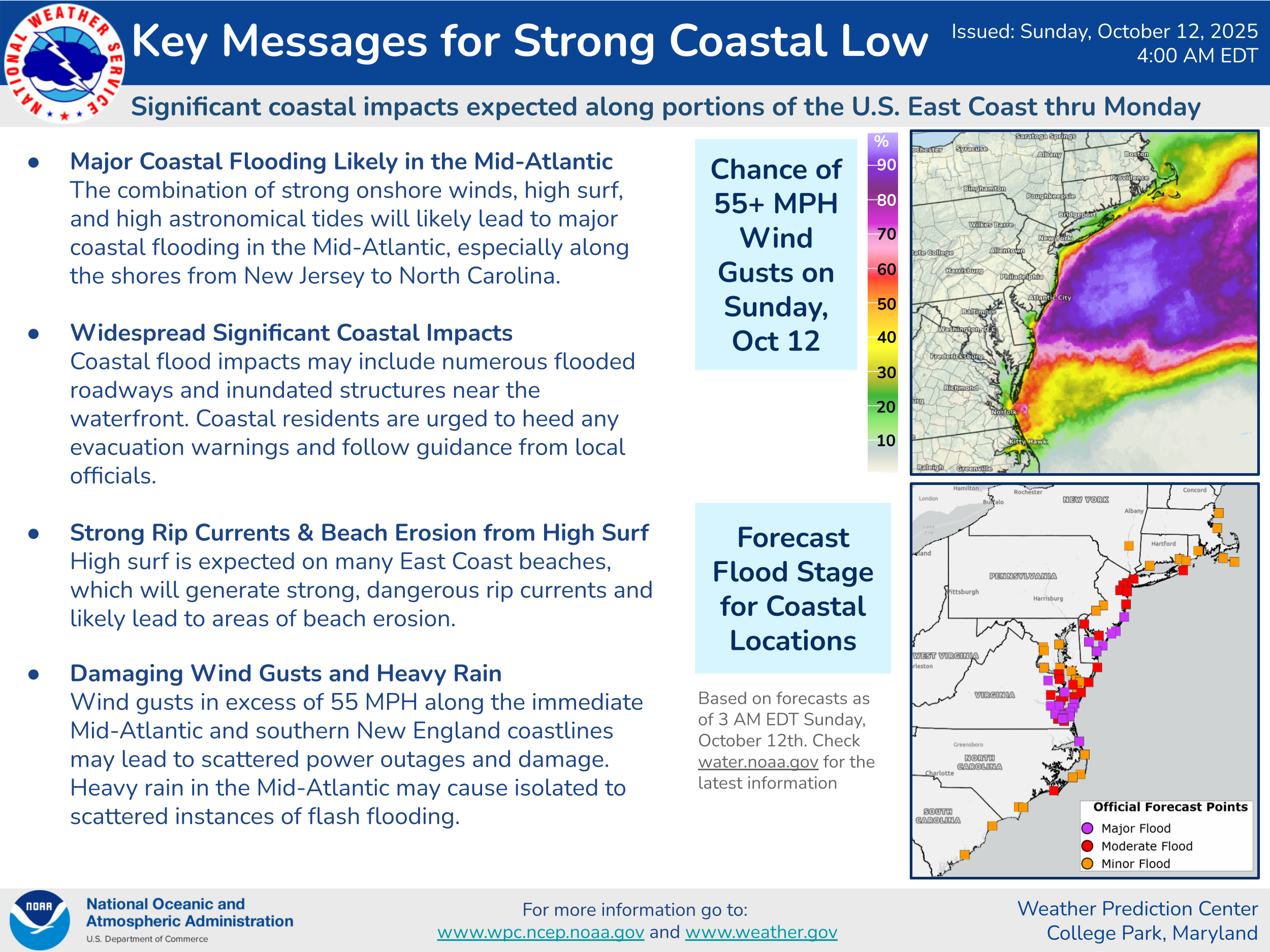
Latest On The Strong Coastal Storm On The East Coast: An area of low pressure is currently located very near the coast of southeastern North Carolina as of the time of this writing. Weather observations as of late this morning show this storm is producing wind gusts of up to 35-45 mph all along the coast from the North Carolina Outer Banks northward to Long Island. These winds are expected to increase even further this afternoon reaching their peak from late today through tonight and into Monday with gusts of up to 50-60 mph likely.
Additionally, this storm is still expected to bring other very significant impacts to areas from the North Carolina Outer Banks and the Tidewater of Virginia northward through the coastal parts of the Delmarva, coastal New Jersey, Long Island and Southern New England. These include several high tide cycles of moderate to major coastal flooding, waves of 15 to 20 feet, beach erosion and 1 to 3 inches of rainfall. The worst of these impacts are expected to occur throughout this afternoon, tonight and Monday.
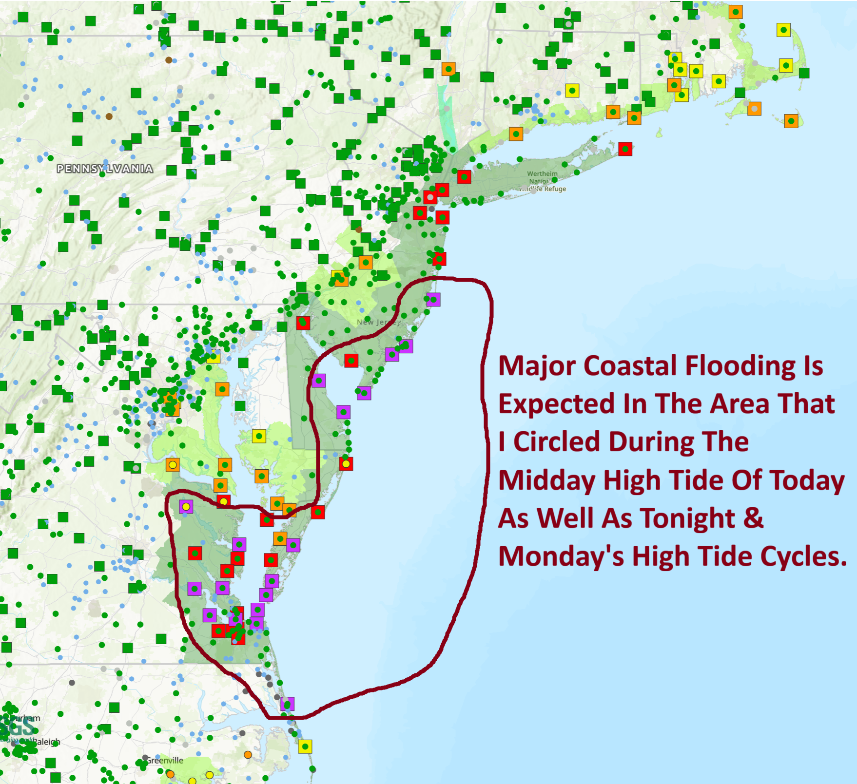
The coastal flooding continues to look to the big threat from this storm:
For The North Carolina Outer Banks & Coastal Virginia: Moderate to major coastal flooding is expected during the high tide cycles of today and tonight. Areas from the northern parts of the Outer Banks through southeastern and eastern Virginia are very likely to see major coastal flooding during today’s midday high tide cycle and tonight’s midnight high tide cycle.
For The Delmarva Coastline & Coastal New Jersey: Major coastal flooding is fully expected during multiple high tide cycles along the Jersey shore through the Delmarva. This means that you should expect major coastal flooding during today’s midday high tide cycle, tonight’s midnight high tide cycle and Monday’s midday high tide cycle. The coastal flooding along the Jersey Shore and the Delmarva is going to be very, very bad & those of you in these areas should be ready for some of the worst flooding since Hurricane Sandy and the January, 2016 Nor’Easter.
For Long Island & Southern New England: Minor coastal flooding looks likely for the beaches of Southern New England and moderate coastal flooding can be expected across Long Island during the high tide cycles of today, tonight and Monday.
By far, the most severe coastal flooding is expected to occur in the area from coastal New Jersey southward through the Delmarva.
The winds with this coastal storm are likely to be quite strong. Wind gusts of 50-60 mph are likely from the North Carolina Outer Banks and the Virginia coastline northward through the Delmarva, the New Jersey coastline and into Long Island and coastal Southern New England. The strongest of these winds look to occur beginning later today and last through tonight and Monday.
In addition to the coastal flooding and strong winds, very rough surf can be expected through Tuesday. This will lead to significant beach erosion all along the coast from the North Carolina Outer Banks northward through the Delmarva, the Jersey Shore, Long Island & Southern New England.
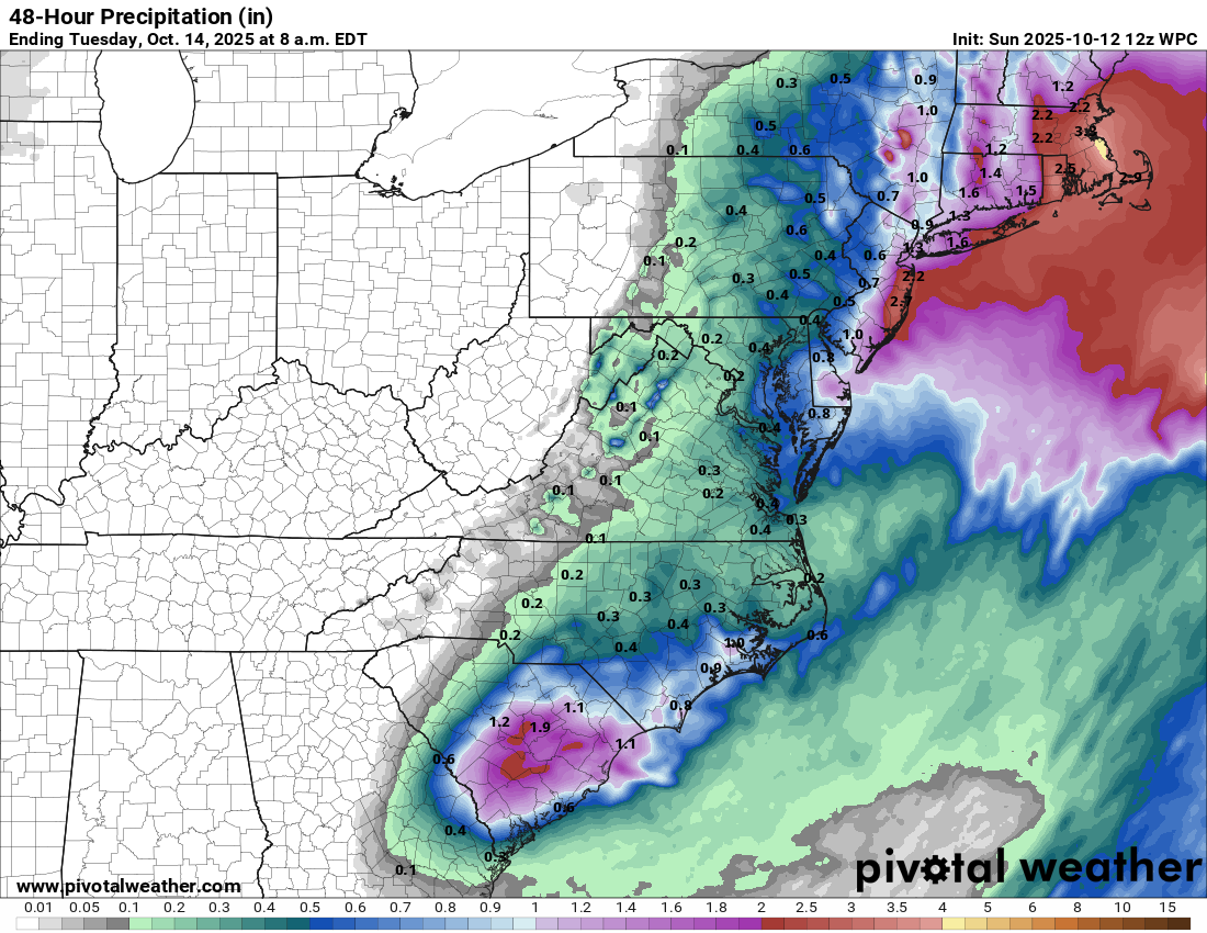
Rainfall totals with this coastal storm look to average between 1 and 3 inches from the Delmarva northward into Southern New England. While this rainfall is not expected to be overly excessive, it could still produce some areas of flooding.
The Bottom Line Is That this is going to be one of the worst nor’easters for the Mid-Atlantic coastline through the Jersey Shore & Long Island in over a decade. Expect major issues and damage along this part of the East Coast. Please take this storm very seriously.
The next tropical weather discussion will be issued on Tuesday.