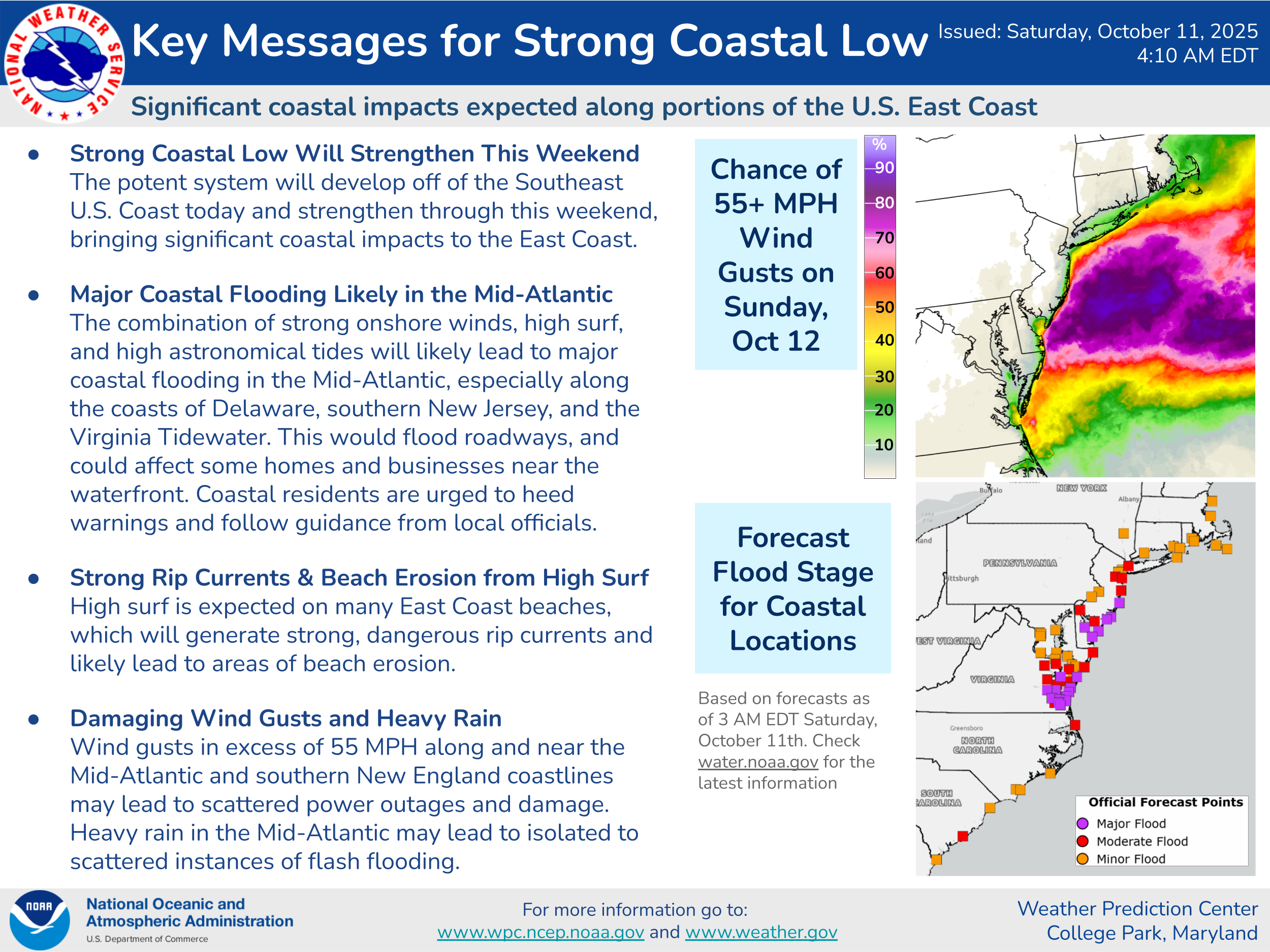
Latest On The Strong Coastal Storm On The East Coast: The latest weather analysis today shows that low pressure is located just offshore of the coasts of Georgia and South Carolina. It continues to look very likely that this storm system will bring very significant impacts to areas from Coastal North Carolina northward to Long Island and Southern New England, especially on Sunday & Monday.
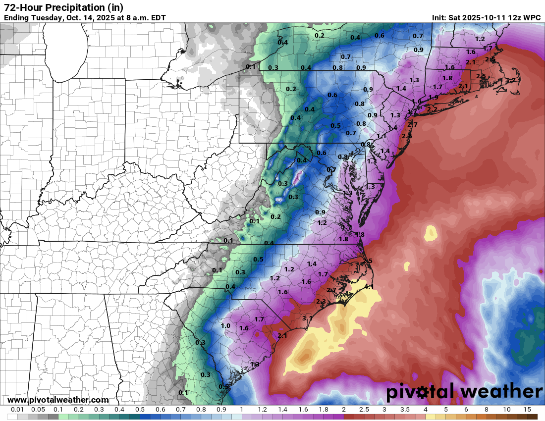
What sort of significant impacts are we talking about from the North Carolina Outer Banks and the Tidewater of Virginia northward through the coastal parts of the Delmarva, coastal New Jersey, Long Island and Southern New England? Several high tide cycles of moderate to major coastal flooding, waves of 15 to 20 feet, beach erosion, wind gusts of 50-60 mph and 1 to 3 inches of rainfall. The worst of these impacts are expected to occur on Sunday, Sunday night and Monday.
First and foremost, the coastal flood threat will be the big story with this storm –
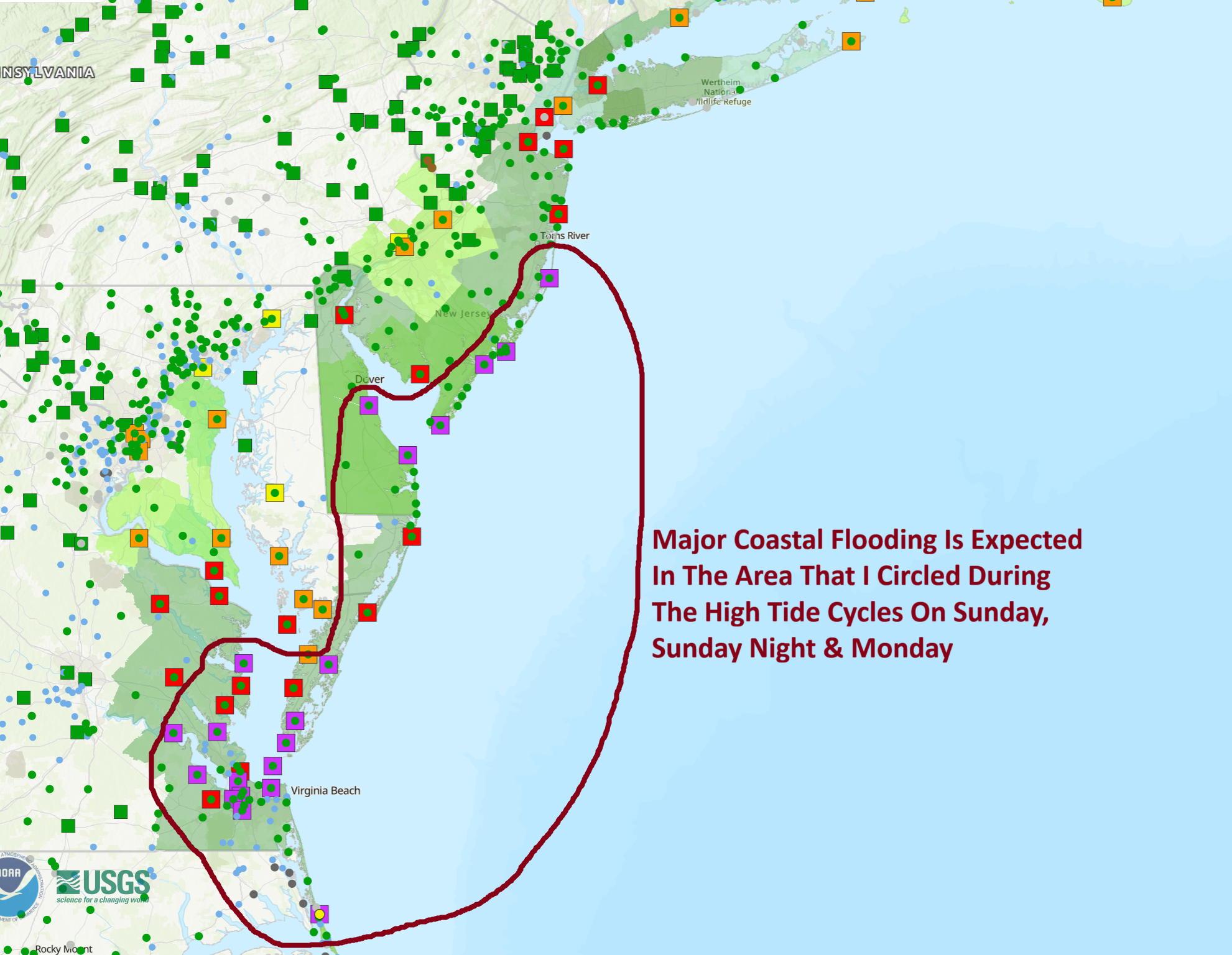
For The North Carolina Outer Banks & Coastal Virginia: Moderate to possibly major coastal flooding is expected during the high tide cycles on Sunday. Areas from the northern parts of the Outer Banks through southeastern and eastern Virginia are very likely to see major coastal flooding during the midday Sunday high tide cycle.
For The Delmarva Coastline & Coastal New Jersey: Major coastal flooding is fully expected during multiple high tide cycles along the Jersey shore through the Delmarva. This means that you should expect major coastal flooding during the midday Sunday high tide cycle. A second and third round of major coastal flooding is then expected during Sunday night’s high tide cycle and during midday Monday’s high tide cycle. The coastal flooding along the Jersey Shore and the Delmarva is going to be very, very bad & those of you in these areas should be ready for some of the worst flooding since Hurricane Sandy and the January, 2016 Nor’Easter.
For Long Island & Southern New England: Since it appears that the strongest gradient with this storm system should stay just south of Southern New England, it appears that generally minor coastal flooding can be expected during the high tide cycles on Sunday, Sunday night and Monday.
Once again, the most severe coastal flooding is expected to occur in the area from coastal New Jersey southward through the Delmarva.
The winds with this coastal storm are likely to be quite strong. Wind gusts of 50-60 mph are likely from the North Carolina Outer Banks and the Virginia coastline northward through the Delmarva, the New Jersey coastline and into Long Island and coastal Southern New England. The strongest of these winds look to occur during Sunday, Sunday night and Monday.
In addition to the coastal flooding and strong winds, very rough surf can be expected that lasts for upwards of 48 hours (starting tonight & Sunday & lasting until Tuesday). This will lead to significant beach erosion all along the coast from the North Carolina Outer Banks northward through the Delmarva, the Jersey Shore, Long Island & Southern New England.
Rainfall totals with this coastal storm look to average between 1 and 3 inches from eastern North Carolina northward through the Mid-Atlantic States into Southern New England. While this rainfall is not expected to be overly excessive, it could still produce some areas of flooding.
The Bottom Line Is That this is going to be one of the worst nor’easters for the Mid-Atlantic coastline through the Jersey Shore & Long Island in over a decade. Expect significant to major issues and damage along this part of the East Coast. Please take this storm very seriously.
Tropical Development Possible Between The Lesser Antilles & The Coast Of Africa Later Next Week & Next Weekend: I think that we will probably have one more decent shot at tropical development in the tropical Atlantic around late next week before things begin to shut down.
An upward motion pulse of the Madden Julian Oscillation seems to be now pushing into the Atlantic Basin & will help to energize a couple of tropical waves over the next week to 10 days.
One tropical wave that is now located over the eastern Tropical Atlantic is very likely to curve to the north quickly & probably will become our next tropical storm as it does so. This first tropical wave, which the National Hurricane Center has highlighted in their latest outlook will be of no threat to anyone & should curve safely out into the open Atlantic.
A second tropical wave, which looks to be currently located over western Africa is expected to push off of the coast of Africa & enter the far eastern tropical Atlantic over the next couple of days. All indications are pointing towards this particular wave becoming a “low-rider” & perhaps developing into a tropical storm near the southern Leeward Islands and the Windward Islands as we get into next weekend.
There is then the possibility that this particular wave could move into the Caribbean during the week of October 20 & if this occurs, it could be a system to watch very, very closely. The ocean waters of the Caribbean are extremely warm & are virtually untouched by tropical systems so far this season. Because of this, any tropical system moving through the Caribbean could become a big, big problem if it is able to get going.
For now though, this is just a tropical wave to keep an eye on, especially once it “splashes down” in the eastern tropical Atlantic in a couple of days from now.
The next tropical weather discussion will be issued on Sunday.