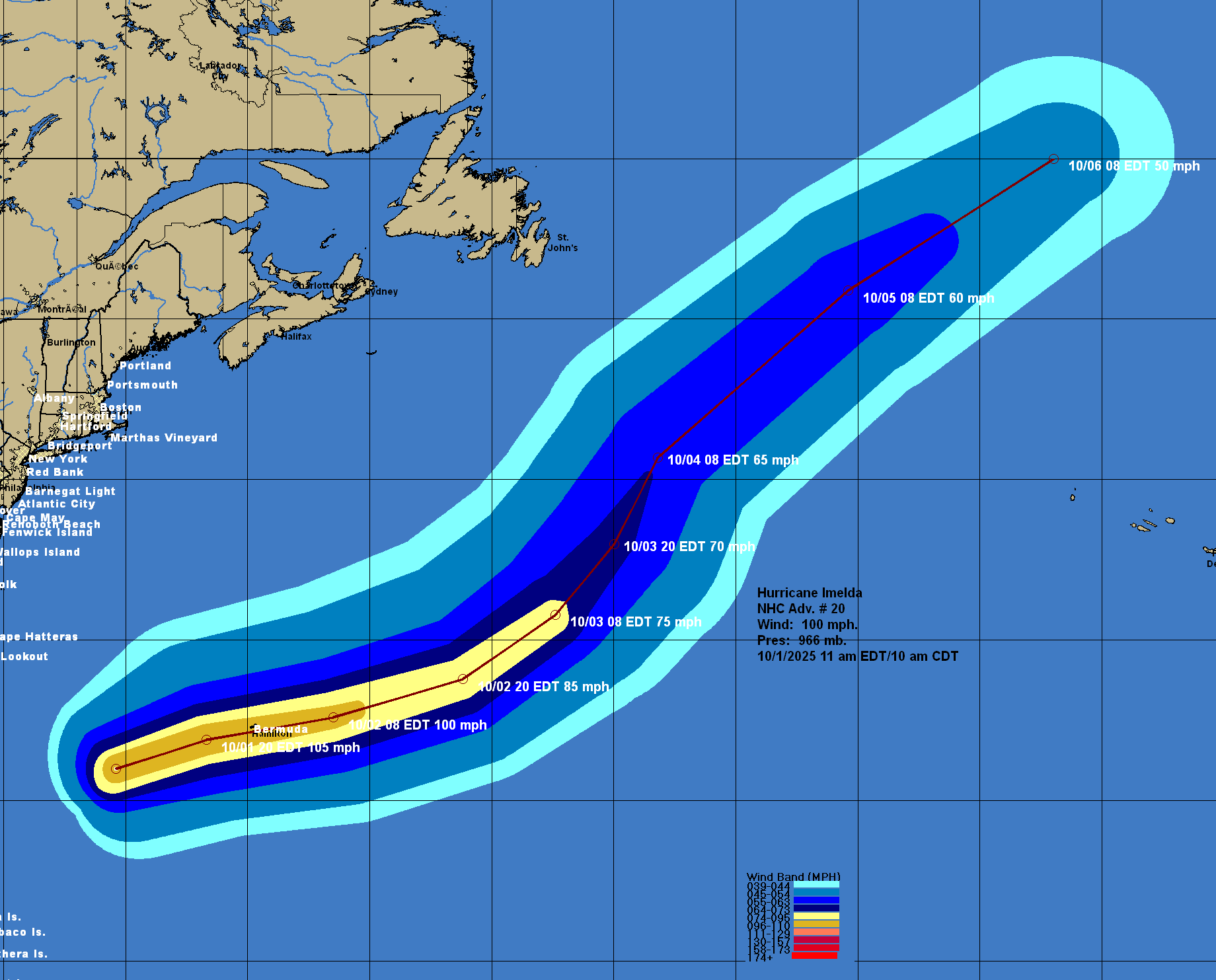
Hurricane Imelda: Imelda is strengthening today as it heads for Bermuda. Reconnaissance aircraft are finding a central barometric pressure of about 966 millibars and maximum winds of around 100 mph. The net wind shear over Imelda right now is very low due to the fact that it is moving in the same direction as the mid and upper level winds. Because of this, additional strengthening is likely & because of this, Imelda could be very near or at Category 3 intensity when it passes over Bermuda tonight. This means that those of you on the island of Bermuda need to be ready for a decent blow with wind gusts of well over 100 mph possible tonight.
Once Imelda passes over Bermuda tonight, it’ll likely become captured by an upper level trough of low pressure over the North Atlantic. Because of this, it’ll transition into an extra-tropical storm as it moves northeastward into the open Atlantic late this week through this weekend.
Forecast Impacts For Bermuda: A direct impact from a Category 2 to Category 3 hurricane is fully expected on the island of Bermuda tonight.
This means that tropical storm force winds will develop on Bermuda this afternoon. Hurricane conditions with wind gusts of well over 100 mph (maybe approaching 110-120 mph) can be expected tonight.
In addition to the very strong winds, heavy rain with amounts of 2 to 4 inches can be expected during this afternoon, tonight and Thursday morning. This rain could lead to areas of flash flooding across the island.
Coastal flooding with large and damaging waves are also expected across Bermuda this afternoon, tonight and Thursday morning.
Finally, it should be noted that Imelda is moving quickly and because of this, much calmer weather conditions will overspread Bermuda as soon as midday Thursday. All-in-all though, I think that we’re looking at extremely rough weather conditions for 8 to 12 hours or so across Bermuda.
Eastern & Central Tropical Atlantic Tropical Development Is A Possibility Next Week: It continues to look possible that we could see tropical development in the area between the coast of Africa and the Lesser Antilles during next week thanks to a tropical wave, which is expected to push off of the coast of Africa in a couple of days from now.
Some of the model guidance and their ensemble members continue to point to this possibility. In fact, most of the ensemble members (both GFS and European model) that do show development indicate a track that could threaten the Lesser Antilles and the eastern Caribbean around Wednesday and Thursday of next week. Beyond this, the ensemble members then suggest any tropical system could be pulled northward into the open Atlantic away from the Bahamas and the United States.
As for the AI models, the Google Deep Mind AI ensemble model seems to be indicating a quicker turn to the north before it reaches the Lesser Antilles leading to no impacts at all.
At this point, I think that the best thing to do is to just keep an eye on this tropical wave once it pushes off of the coast of Africa on Friday. The good news is that we have plenty of time to keep an eye on it & because of this, it’s nothing to be overly concerned or worried about if you are in the Leeward Islands or the northeastern Caribbean.
The next tropical weather discussion will be issued on Thursday.