Two robust tropical disturbances, Invest 93-L (the easternmost disturbance) and Invest 94-L (the westernmost disturbance, are likely to develop into tropical storms and possibly hurricanes over the next few days & could very well become viable threats. The westernmost disturbance, Invest 94-L, is likely to track through the Bahamas & then be a very real threat to areas from Florida through the Carolinas to the Mid-Atlantic coast early next week. The easternmost disturbance, Invest 93-L, could end up being a threat to Bermuda early next week.
It needs to be emphasized that the overall forecast of both Invest 93-L and Invest 94-L is extremely uncertain as both systems will influence each other in both track and strength. In fact, these two disturbances could end up rotating around each other in what’s called the Fujiwhara effect.
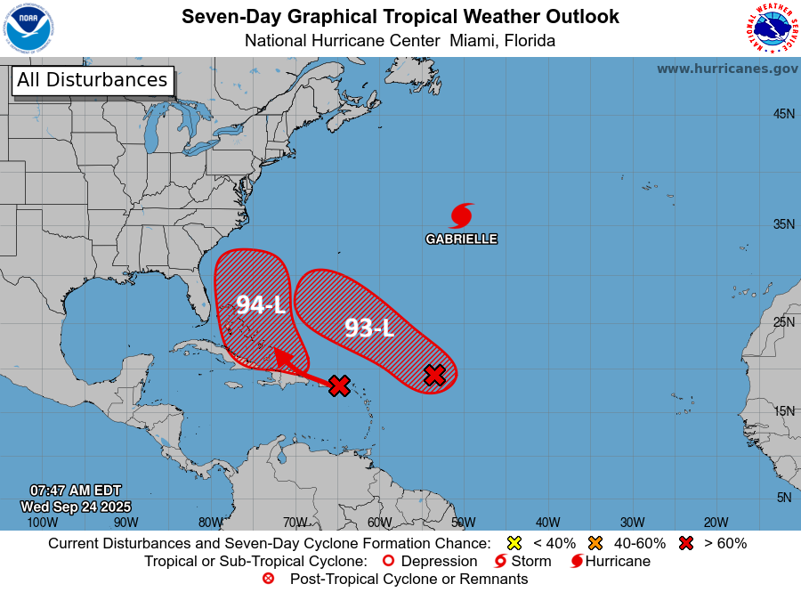
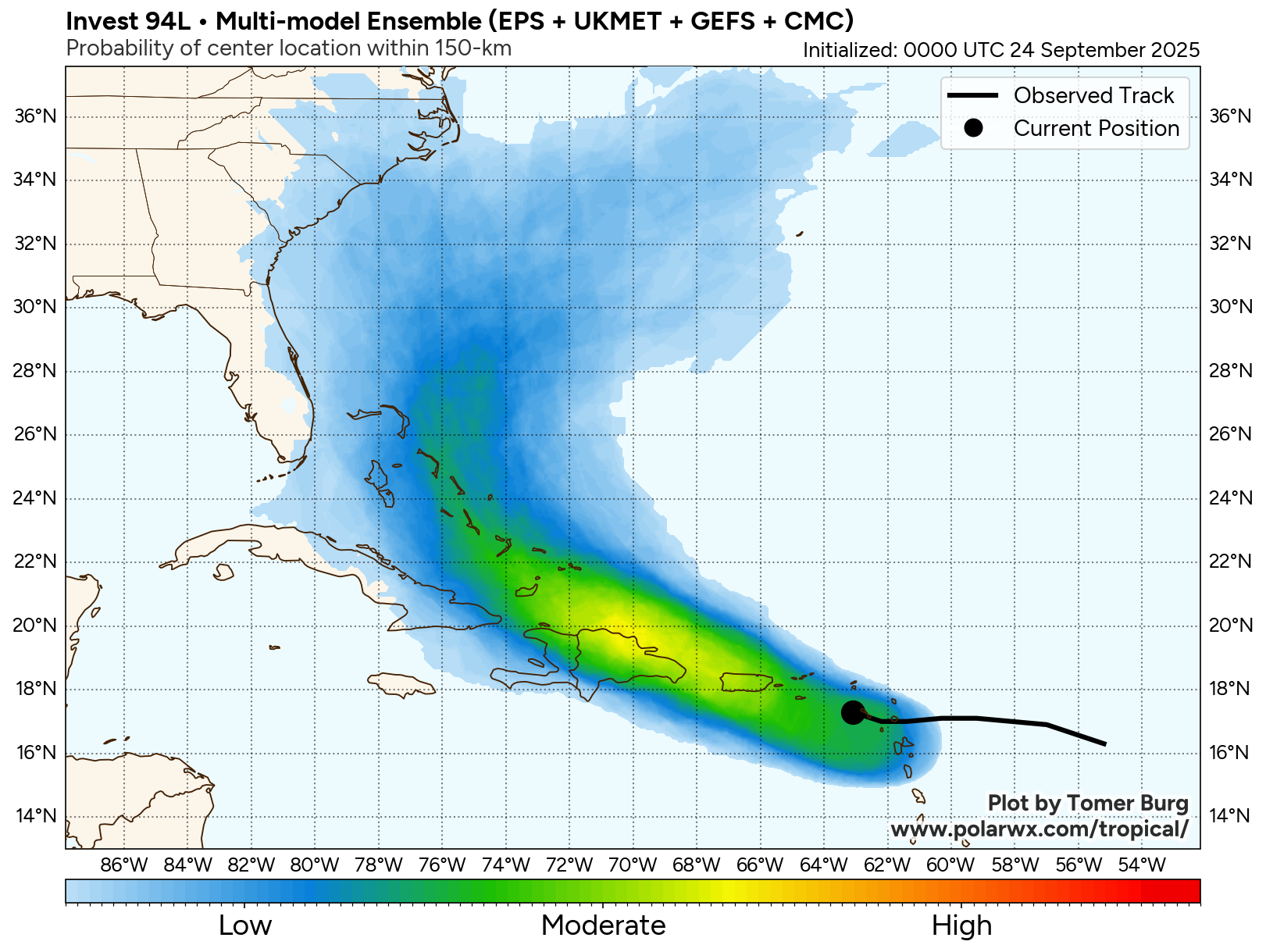
Invest 94-L: First, to discuss the westernmost disturbance, Invest 94-L, which is located over the northeastern Caribbean.
Satellite imagery today reveals that the convection around Invest 94-L is disorganized & there seems to be 20-40 knots of west-northwesterly wind shear affecting it. Because of this, development is not expected for at least the next couple of days.
Beyond this, the forecast track and strength of Invest 94-L becomes highly uncertain once it reaches the Bahamas by early this weekend as it will be heavily affected by Invest 93-L.
My thinking is that Invest 94-L should track into the area around the Bahamas by this weekend. An upper level low pressure system over the Southeastern United States will produce a south to north upper level wind flow causing Invest 94-L to turn to the north by about Sunday and Monday. This is when the influence of Invest 93-L will come into play and thus will probably lead to all sorts of forecasting headaches as scenarios run everything from a track right into the Carolinas all the way to being yanked out into the open Atlantic. More on this later in this discussion.
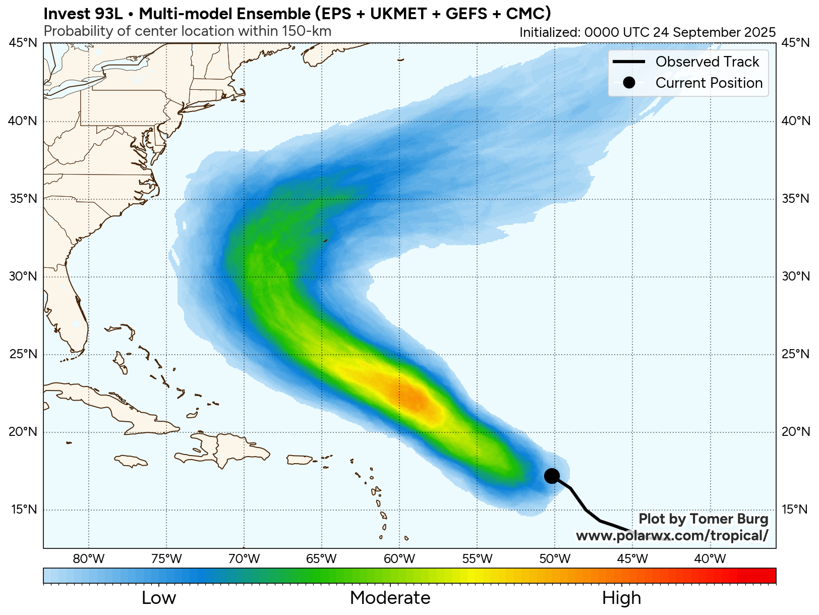
Invest 93-L: Invest 93-L, which is the easternmost disturbance, seems to be organizing today with satellite imagery revealing an elongated area of convection. It seems likely that Invest 93-L will be the first one of the two disturbances to develop and in fact, it could be a depression as soon as later tonight or on Thursday.
With Invest 93-L being the easternmost disturbance, it’ll be a lot harder for it to close in on the East Coast of the United States. Instead, I could see it becoming a very real threat to Bermuda by early next week. That said, it’s possible that Invest 93-L could try to rotate to the north of Invest 94-L and try to track towards the northwest and west-northwest during next week leading it to try to come close to the New England coastline.
Again, the interaction between this disturbance and Invest 94-L is going to make for a very difficult and uncertain forecast.
The Interaction Between Invest 93-L & Invest 94-L Makes For An Extremely Uncertain & Complicated Forecast: Both Invest 93-L and Invest 94-L are expected to track in a westerly direction over the next couple of days. By this weekend, both disturbances will likely turn towards a northerly direction as they are guided on the western side of a high pressure ridge over the central North Atlantic.
The forecast then becomes very complicated as these two systems will get quite close to each other in distance & because of this, they will influence both the track and strength of both disturbances.
It’s actually possible that Invest 93-L and Invest 94-L will be close enough to each other next week, so that the Fujiwhara effect could occur. What is the Fujiwhara effect? It’s when the two circulations (Invest 93-L and Invest 94-L) become entangled with one another & end up rotating around a common pivot point. This is something that is uncommon in the Atlantic, but it can sometimes happen.
Most of the model guidance seem to want to keep these two systems distinct tropical systems, however, the guidance are not in agreement with each other on which system might be the stronger and more dominant one.
The European model, for example, forecasts that both Invest 93-L and Invest 94-L will be hurricanes by early next week.
The GFS model, on the other hand, show that the westernmost system (Invest 94-L) will be quite weak & Invest 93-L (the easternmost system) will be the one to become a hurricane. In fact, the GFS model forecasts that Invest 93-L will end up absorbing the circulation of Invest 94-L.
The Google Deep Mind AI model looks similar to the European model and shows the potential for two dueling hurricanes that will be close to each other in distance by early next week.
Bottom Line Is That If you live in Bermuda, the Bahamas, or on the East Coast from the Florida Peninsula through the Carolinas and the Mid-Atlantic coastline to Southern New England, keep close tabs on the progress of what is going on with these two systems. I cannot emphasize enough how uncertain the forecast is. When you get two systems like this in-close to each other, some very strange things can happen. Everything from significant land impacts to some part of the East Coast to both systems harmlessly heading out into the open Atlantic are possible.
Finally, the next two names on the list are Humberto and Imelda. I do think that the easternmost disturbance (Invest 93-L) will probably be Humberto and the westernmost disturbance (Invest 94-L) may end up becoming Imelda at some point.
The next tropical weather discussion will be issued on Wednesday.