With Hurricane Gabrielle heading safely out into the open Atlantic, I want to concentrate a lot more on Invest 94-L, which poses a potential threat to the Bahamas & parts of the East Coast of the United States and Invest 93-L, which might pose some threat to Bermuda.
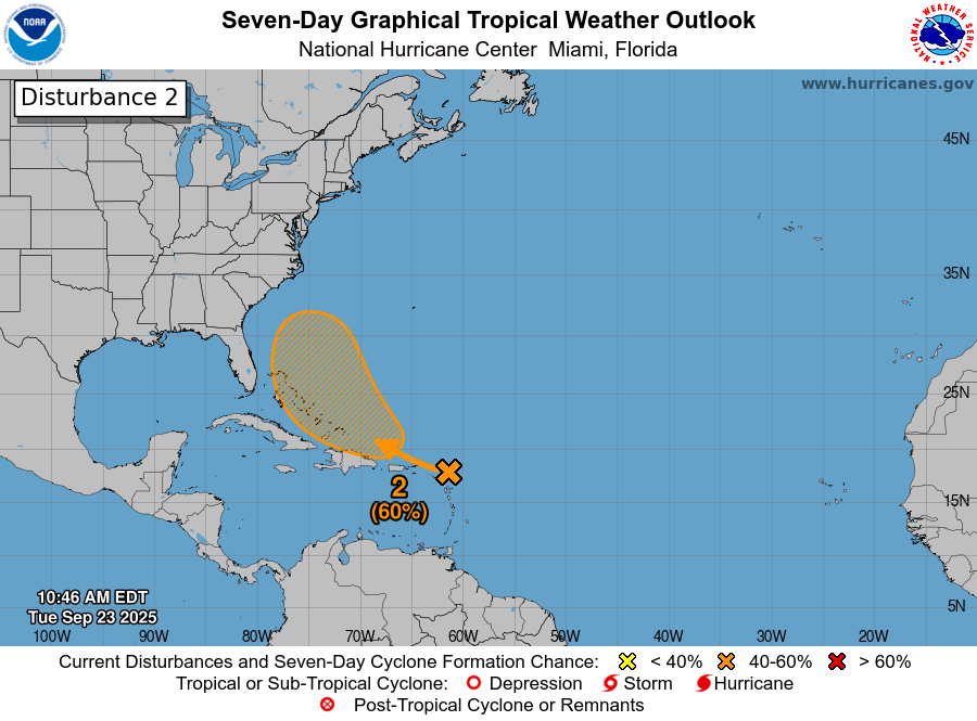
Invest 94-L Located Over The Lesser Antilles: Satellite imagery and weather analysis today indicates that the northerly wind shear that has been affecting this system has caused it to track more to the south than what the guidance indicated even yesterday. Because of this, it looks very likely now that Invest 94-L will continue to track right through the Lesser Antilles during the rest of today before it heads right over Puerto Rico and Hispaniola during Wednesday into Thursday.
This means that those of you in the Windward and Leeward Islands will continue to see occasional squally weather throughout the rest of today into tonight. This squally weather will affect much of the Virgin Islands, Puerto Rico and Hispaniola throughout Wednesday and will probably last into Thursday.
Strong northerly wind shear is expected to continue to affect Invest 94-L over the next 2-3 days or so and because of this, development is not expected anytime too soon. As we get into Friday and Saturday, however, the environmental conditions around this disturbance will become more favorable for development, just as its moving into the southeastern Bahamas.
A look at the latest model guidance reveals that it seems both the conventional models and the AI models now forecast development of Invest 94-L and also forecasts it to get quite close to the East Coast of the United States.
The Google Deep Mind AI model looks quite aggressive in showing Invest 94-L being a threat to not only the Bahamas but also to the Southeast coast of the United States during the early part of next week.
The European AI model also shows Invest 94-L being a threat to the Southeast coast of the United States during the early part of next week.
As for the conventional models, the GFS ensemble model guidance is further offshore than the AI models and most ensemble members show a close brush with the outer banks of North Carolina early next week.
The European ensemble model guidance looks further west than the GFS ensemble guidance with a few members pointing towards a coastal North Carolina impact early next week.
Here Are My Thoughts: As I mentioned yesterday, those of you in the Bahamas and along the US East Coast should keep a close eye on the progress of Invest 94-L as it could be a problem come late this weekend and early next week.
The environmental conditions around Invest 94-L are currently unfavorable for development, but are expected to become favorable when this system moves into the Bahamas this weekend. This means that we could very well have a developing tropical system right in the Bahamas by early this weekend.
The weather pattern during this weekend into early next week looks quite complicated & because of this, the overall track of whatever forms is highly uncertain. There’s the expectation that there will be a cutoff upper level low pressure system in place over the southeastern US with a high pressure ridge located over southeastern Canada. This is a pattern that is actually quite favorable for an East Coast tropical impact. That being said, the influence of the other tropical disturbance, Invest 93-L, located just to the east of Invest 94-L could lead to some high jinx in the forecast.
It’s possible that the interaction between Invest 94-L and Invest 93-L could cause both systems to completely miss the entire East Coast of the US, especially if the disturbance further east (Invest 93-L) gets stronger & has more influence on the overall weather pattern.
It’s equally as possible that the upper level low pressure system is able to capture Invest 94-L and guide it to the north-northwest towards the Southeast coast of the United States or the Mid-Atlantic coastline early next week.
Bottom line is that all interests along the East Coast from the Florida Peninsula to New England should monitor the progress of Invest 94-L. The area that I’m most concerned about in terms of any impacts are along the Carolina and Mid-Atlantic coastlines. That said, there is still A LOT to figure out with this system & how the overall weather pattern will affect it. Also, there’s the question on how Invest 94-L will interact with Invest 93-L. All-in-all, a very uncertain forecast.
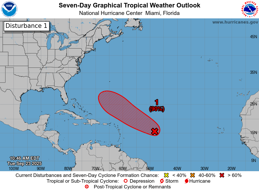
Invest 93-L Located About 1000 Miles To The East Of The Lesser Antilles: Located to the east of Invest 94-L is another tropical disturbance, designated Invest 93-L. This disturbance is located about 1000 miles or so to the east of the Lesser Antilles.
Right now, Invest 93-L seems to be gradually organizing & probably will develop in the coming days. All signs seem to point towards Invest 93-L strengthening into a tropical storm and possibly a hurricane as it curves to the north away from the Caribbean, but towards Bermuda.
While there is potentially a threat to Bermuda early next week from Invest 93-L, it seems as if this system will curve far enough offshore to not be a threat to the Bahamas or the East Coast of the United States.
The next tropical weather discussion will be issued on Wednesday.