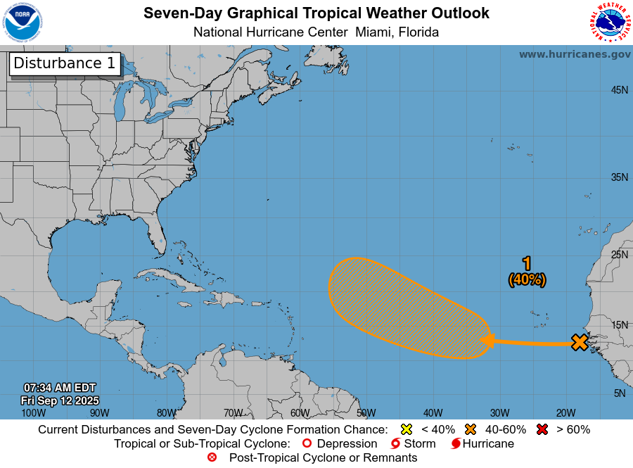
Tropical Wave Near The West Coast Of Africa: Satellite imagery and weather analysis indicates that there is a tropical wave that is located near the west coast of Africa. The convection associated with this wave looks quite disorganized with a lack of any concentrated thunderstorm activity.
It is expected that this wave will head across the eastern Tropical Atlantic this weekend and reach the central Tropical Atlantic by early next week. It appears that the conditions should be a little more favorable for this wave to develop next week, especially when it turns towards a northwesterly direction later next week.
Looking at the model guidance – There is some decent agreement between the guidance members in showing this wave developing into our next named storm, probably during the second half of next week as it turns to the northwest and heads into the open Atlantic well east of the Caribbean. That being said, it is likely that this wave will encounter both dry air and unfavorable wind shear values as it tracks across the eastern and central Tropical Atlantic over the next few days. Because of this, my expectation is that we’ll probably see slow to even very slow development of this wave through the middle part of next week with the rate of development increasing once it moves north of 20 North Latitude late next week.
Whether this system develops or not (it probably will develop into Tropical Storm Gabrielle at some point), it will not be a threat at all to the Caribbean, the Bahamas or the United States.
Elsewhere Across The Atlantic, Caribbean & Gulf: A look at the weather analysis today, it shows that we have a frontal boundary that extends from South Florida and the northern Bahamas east-northeastward into the north Atlantic. While these frontal boundaries are always something to watch for development this time of year, there’s nothing at all that warrants any sort of attention in terms of possible development.
Looking further east, an upper-level low pressure system located over the central North Atlantic is producing a large area of thunderstorms. No development is expected from this weather feature.
Turning to the tropical Atlantic, there is a tropical wave that will be moving through the Windward Islands over the next 12-24 hours or so. While this wave will bring some showers and scattered thunderstorms to the Windward Islands, tropical development is not expected.
Even though things are quiet right now in terms of tropical development chances, things may gradually become more active starting late next week, but especially during the week of September 22. The model guidance are showing the potential for some robust tropical disturbances moving westward across the deep tropics during this time frame. Where these disturbances go and how strong they become are an unknown right now as it is way too soon to make those types of determination.
That said, it should be noted that some of the model guidance are honing in on a tropical wave that may really need to be watched . This particular wave is expected to push off of the coast of Africa during the first half of next week & may take a much further south track. In fact, the ensemble guidance of both the GFS and European models seem to hint at this disturbance affecting the Lesser Antilles around September 22 or 23. Beyond this, the ensemble guidance diverges on where this system goes with some members showing it moving from east to west across the Caribbean & other members showing it ending up in the southwestern North Atlantic in about 2 weeks from now.
At this point, this is just a tropical wave to just keep an eye on once it moves off of the coast of Africa next week. For now, do not worry or concern yourself about this wave.
Finally, the GFS model is up to its usual tricks this time of year of spinning up tropical systems in the western Caribbean during the 10-15 day forecast range. This is a bias of this model & any western Caribbean tropical development shown by the GFS model this time of year should be viewed with a lot of skepticism. Now, if we start seeing other more reliable models start showing the same thing, then I’ll start paying attention more. Right now though, only the GFS model is showing a tropical system spinning up in the western Caribbean. That said, the tropical system that the European model is showing in the northwestern Caribbean 2 weeks from now is from the tropical wave that’ll be moving off of the coast of Africa. Again though, even though the European model is a good model, it can also over strengthen systems in its longer range forecasts.
The takeaway from the models showing development in the western Caribbean by the week of September 22 is that while these specific model forecasts probably will not verify, it is a good reminder to keep a very close eye on the western Caribbean and the Gulf as we get into later this month and early next month. Some of the bigger threats historically to the US coastline have come from the Caribbean and the Gulf & these storms often come with a lot less warning than from the long-track storms.
The next tropical weather discussion will be issued on Saturday.