Tropical Storm Fernand: Fernand seems to be trying to strengthen today as satellite data reveals that the storm has maximum winds of 50 mph. This burst of strengthening looks to not last much longer as it will be moving into progressively colder ocean waters over the next couple of days. This means that Fernand will likely weaken and become post-tropical as we get into Thursday.
Additionally, Fernand will continue to head out into the open Atlantic & continue to not be a concern to any land.
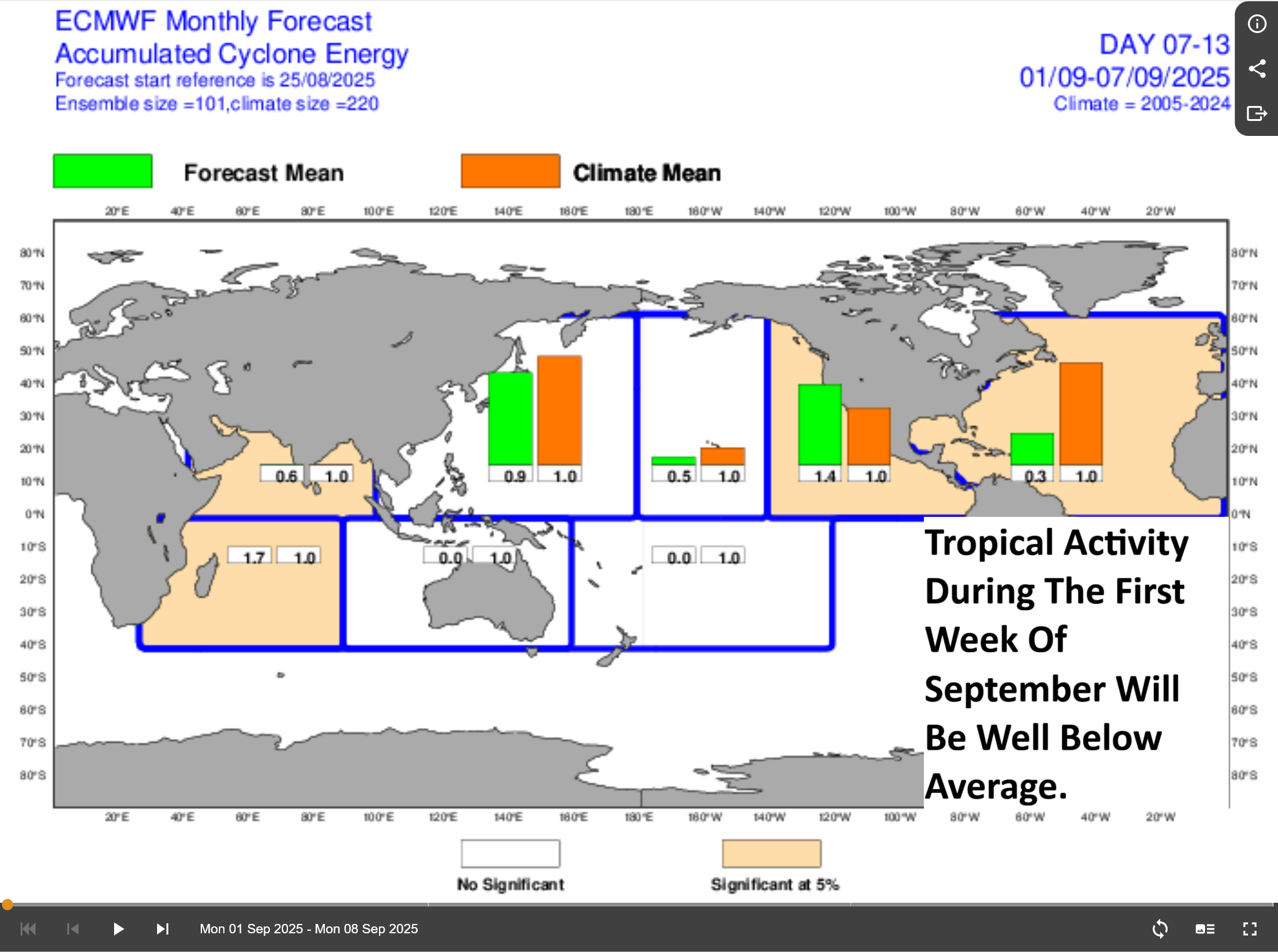
Elsewhere Across The Atlantic, Caribbean & Gulf: The rest of the Atlantic Basin is unusually very quiet for late August. It appears that these quiet conditions will last right into the first week of September.
The reason why the Atlantic is quiet is due to widespread unfavorable conditions across the Atlantic as a downward pulse of the Madden Julian Oscillation makes its way across the Atlantic.
Does this mean that there is nothing to keep an eye on? Nope.
One thing that I continue to keep an eye on is a frontal boundary that’s draped from off of the East Coast of the United States southwestward through the Florida Peninsula into the southern Gulf. These decaying fronts can sometimes be a source of tropical development as areas of low pressure form near the tail end of the front, break off from the front and then develop into a tropical system.
While there is no areas of low pressure to watch right now, the various model guidance continue to indicate that a couple of low pressure systems may form in the area from just north of the Bahamas westward to the eastern Gulf and then try to head up the East Coast of the United States late this weekend into early next week. The guidance does seem to insist that these low pressure systems will be non-tropical in nature & not amount to much.
What these low pressure systems might end up doing is to bring some enhanced thunderstorm activity to much of the Florida Peninsula during this weekend into the first half of next week. These low pressure systems may also bring some locally squally weather, areas of showers & some gusty onshore winds to the immediate coastal areas of the Carolinas early next week.
No matter what these low pressure systems do, I will be keeping an eye on them, just in case.
One other item that I’m watching is a tropical wave that’s located over western Africa. This wave is expected to push off of the coast of Africa into the far eastern Atlantic by late this week and this weekend. The reason why I’m mentioning it is because some of the weather models are showing it trying to develop as it heads westward across the Atlantic during next week. In fact, the European ensemble guidance is giving this wave about a 30-40 percent chance of development as it heads westward across the eastern and central Tropical Atlantic.
This wave could be something to keep an eye on next week, although, we will have a long time to really watch it & because of that, I’m not overly concerned about it. It should be noted that the overall conditions across the Atlantic next week does look unfavorable and because of that, this wave will probably struggle to develop and any development should be slow to occur.
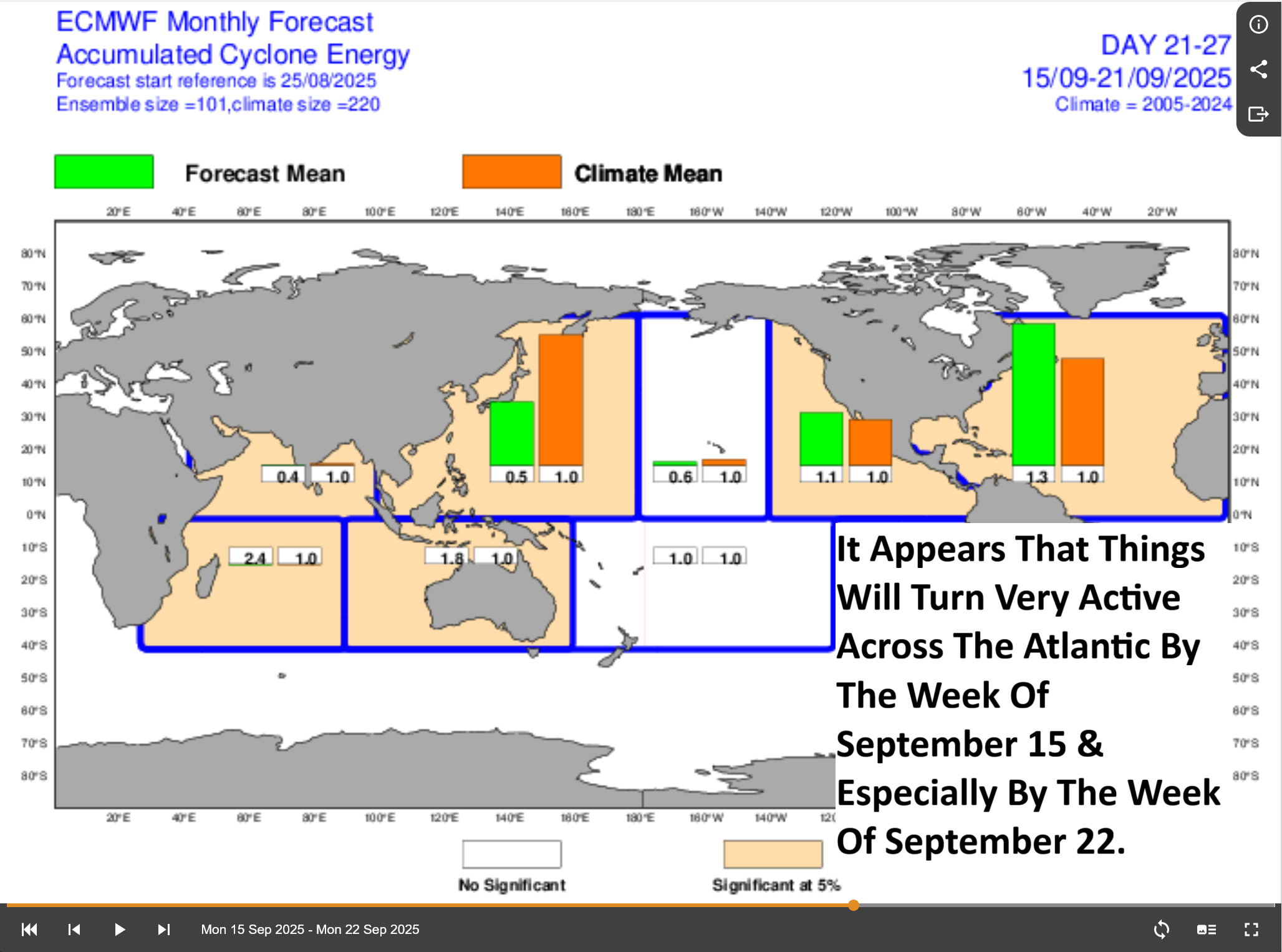
Activity Across The Atlantic Looks To Pick Up Again By Mid-September: It does look like conditions will become largely favorable again for development across the Atlantic by about the September 10-15 time period as a new upward motion pulse of the Madden Julian Oscillation makes its way into the Atlantic & I do think that activity will pick up in earnest by about mid-September. In fact, I fully expect that the second half of September and the first half of October could be quite active across the Atlantic, Caribbean and Gulf.
The longer range model guidance seems to support the idea of an active second half of September with the European model forecasting almost double the average amount of activity by the week of September 22.
So, let’s all try to enjoy the rare late August and early September breather in terms of tropical activity because, unfortunately, hurricane season is far from being over. In fact, I think that a very active backloaded season is very much likely.
The next tropical weather discussion will be issued on Friday.