Looking at the Atlantic Basin today, it appears that the activity has gotten a little more active than what it looked like even on Friday.
The First Item Of Note Is an area of fairly robust thunderstorms that are located to the north of the Lesser Antilles near about 24 North Latitude, 61 West Longitude. These thunderstorms are occurring on the northern end of a westward moving tropical wave.
A look at the environmental conditions around this wave reveals that the wind shear values are marginally favorable for development right now, but there is some much stronger wind shear values found just to the west. Also, there is very little or no low or mid-level circulation occurring with the wave – meaning that there is no low pressure forming in association with the thunderstorm activity.
My take on this first item is that even though the thunderstorm activity looks fairly robust on satellite imagery, there is very little evidence in the data that suggests it’s going to develop. This means that the chances of development are near zero.
The Second Item That I’m Watching Is a tropical wave that is now pushing off of the coast of Africa. The convection with this wave is robust, but is also disorganized. A look at the environmental conditions reveals that the wind shear values are favorable for development. The impediment to any development of this wave as it moves westward is going to be an abundant amount of dry air.
After showing development late last week, all of the model guidance have backed off on their forecasts of development this week as it heads westward. The likely reason why guidance no longer shows development is probably due to all of the dry air between the Lesser Antilles and the coast of Africa.
My feeling is that there is a very low chance of tropical development as this tropical wave heads westward and approaches the Lesser Antilles later this week. That said, I will be keeping an eye on this wave as it heads westward this week, just in case.
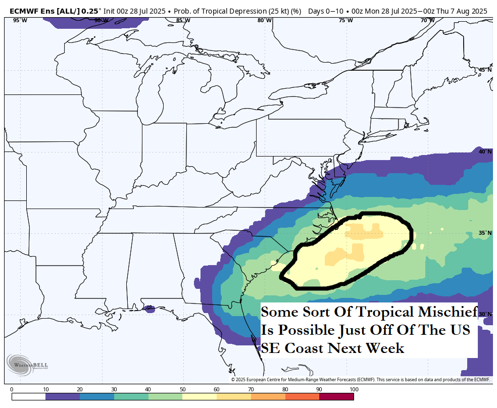
Will There Be Tropical Mischief Off Of The Southeast Coast Of The United States Next Week? – There is the possibility that we could see some sort of tropical mischief just offshore of the US Southeast coast next week as that tropical wave that’s now located near the coast of Africa lifts northwestward from the Lesser Antilles late this week to the Bahamas early next week. At the same time this is happening, it’s possible that we could see a low pressure system form near the tail end of a front offshore of the Southeast coast of the US. This combination could lead to the development of a tropical system next week somewhere in the area between Bermuda and the northernmost Bahamas.
You see some very different results when you look at the model guidance.
On one hand, the GFS ensemble model guidance seems to suggest any low pressure system will remain frontal in nature and just head east-northeastward away from the Carolina coastline and into the open Atlantic.
On the other hand, the European ensemble model guidance hints at any low pressure system that forms might hand around near the Carolina coastline next week and try to form. In fact, the European ensemble model guidance is showing a 40-45 percent chance of tropical development near the South Carolina coast by early next week.
The AI models such as the Google Deep Mind AI weather model shows a very messy scenario of any tail end low pressure systems trying to absorb the energy and moisture from that tropical wave. This leads to a tight clustering of ensemble members showing development in the area between the Bahamas and Bermuda early next week. The AI ensemble models then diverge wildly with some members curving this system out into the open Atlantic & other members showing a track towards the US Southeast coast later next week.
All-in-all, I do think that the area just offshore of the Southeast Coast of the United States needs to be watched closely for potential development as soon as early next week. It’s something that I will be keeping an eye on & will have more updates in the coming days.
The next tropical weather discussion will be issued on Wednesday.