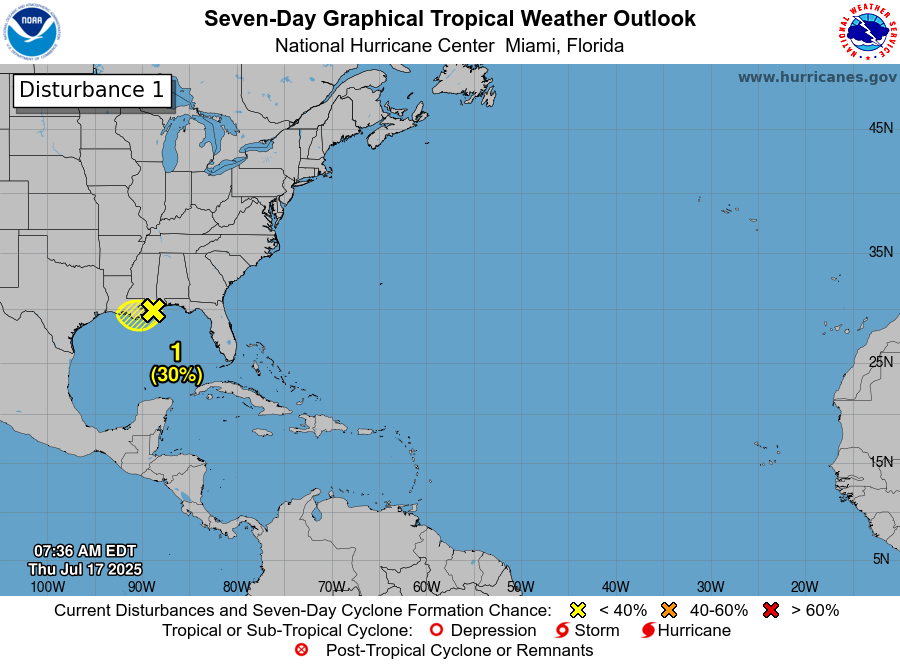
Invest 93-L Located Over The North-Central Gulf: Invest 93-L is currently located over the north-central Gulf and is expected to move inland into southeastern Louisiana this afternoon or this evening. It’s now highly certain that Invest 93-L will not develop into a depression before it moves inland.
What Invest 93-L will do is produce several rounds of heavy rainfall across southern Louisiana throughout the rest of today right through Friday.
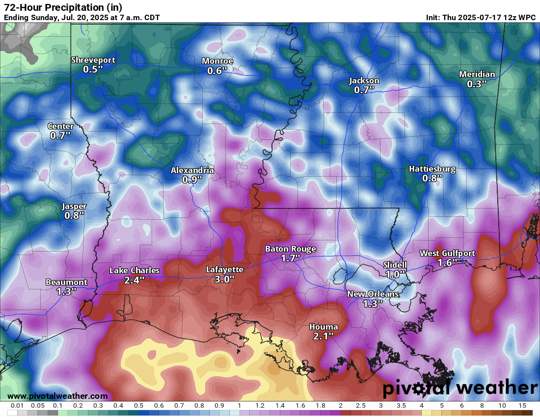
Rainfall totals the rest of today through tonight will be anywhere between 2 and 4 inches across much of southern Louisiana with the highest amounts occurring in the area from Lake Charles eastward to Lafayette and then southward to New Iberia and Houma. Localized flash flooding is quite possible, especially in areas that see high rain rates.
Additional rounds of heavy rain can be expected throughout Friday.
All-in-all, total rainfall amounts of 3 to 6 inches can be expected over the next couple of days across much of southern Louisiana. Local rain amounts of up to 6 to 10 inches are a possibility, especially in the area around Vermilion Bay.
While the flood threat looks much less threatening than it did a couple of days ago, it should also not be dismissed as localized flash flooding will be a hazard across much of southern Louisiana throughout the next couple of days.
No Tropical Development Is Expected Through This Weekend Across The Atlantic Basin, But……: There are no other areas of concern in terms of tropical development across the rest of the Atlantic Basin right now. In fact, no tropical development is expected right through this weekend.
I did want to mention the tropical waves that are now moving off of the coast of Africa every few days. One tropical wave is currently located over the east-central Tropical Atlantic near 37 West Longitude. Satellite imagery indicates that this wave is producing some shower and thunderstorm activity and the conditions are currently favorable for development. That said, the environmental conditions are expected to become highly unfavorable for development by the time this wave reaches about 45-50 West Longitude. Because of this, I do not expect to see any sort of development of this tropical wave as it heads westward over the next few days.
Two other tropical waves loom to the east of this wave, one now pushing off of the coast of Africa and the second located over west-central Africa. These two tropical waves may need to be watched a little more closely as they push westward across the eastern and central Tropical Atlantic next week. In fact, the European ensemble model guidance is forecasting up to a 25 percent chance for tropical development over the east-central Tropical Atlantic during the middle and later parts of next week. The European ensemble model guidance then forecasts the development chances to fall to about 15 percent as one of the two waves approaches the Lesser Antilles next weekend.
So, the two tropical waves that are now located from the far eastern Tropical Atlantic to west-central Africa might need to be watched as they head westward across the eastern and central Tropical Atlantic. For now, it’s something to watch, but is nothing to be concerned or worried about.
Development Chances Across The Atlantic Basin May Increase At The Very End Of This Month & During Early August: Changes are in the air as we get into the very end of this month and into early August.
It still looks quite possible that an upward motion pulse of the Madden Julian Oscillation will move into the Atlantic Basin during the last few days of this month and remain in place during early August. This will shift the background state of the tropical Atlantic from widespread unfavorable conditions due to sinking air to a more favorable environment for development due to rising air over a large part of the Atlantic.
The various model guidance supports this idea of a favorable phase for development being in place over the Atlantic during the first half of August. Furthermore, model guidance seems to be suggesting that the amount of wind shear over the Caribbean will decrease substantially by early August leading to a more favorable environment for development.
Looking at the longer range model guidance, they seem to hint that the tropical waves pushing off of Africa may have a little more oomph as we enter August with guidance such as the CFS model showing a few waves trying to develop as they head westward. Also, the European ensemble model is forecasting a 15-25 percent chance for tropical development in a large area between the eastern Caribbean islands and the west coast of Africa during the first week of August. During the second week of August, the European ensemble model guidance is forecasting a 20-30 percent chance for tropical development across the central and eastern Tropical Atlantic.
This will be something that I’ll be keeping an eye on for sure and I will have many more updates over the next couple of weeks.
The next tropical weather discussion will be issued on Friday.