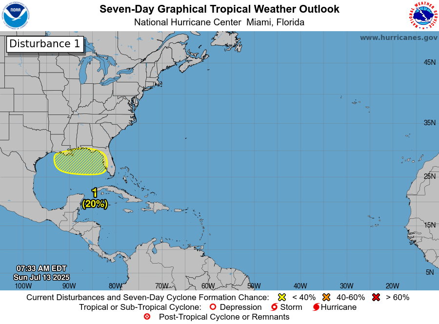
Northern Gulf Tropical Development Continues To Be Possible During The Middle & Later Parts Of This Week: Satellite imagery today indicated that there is a concentrated area of shower and thunderstorm activity located just offshore of the coasts of northeast Florida, southeast Georgia and eastern South Carolina. Weather analysis reveals that an area of low pressure may be trying to form in this area. This is the system to watch this coming week for potential tropical development.
It is expected that this area of disturbed weather will begin to head in a southwesterly and then westerly direction during Monday and Tuesday. This will lead to this disturbed weather to cross the Florida Peninsula during the day on Tuesday and then push into the northeastern Gulf by Tuesday night and Wednesday.
Once this disturbed weather reaches the northeastern Gulf on Wednesday, it is expected to find itself in an environment that’s somewhat favorable for development. This means that this disturbed weather has a chance, at least, to develop into a tropical depression or a tropical storm as it heads westward across the northern Gulf later this week.
Latest Model Guidance: The model guidance vary quite a bit between each other on whether they forecast development of this disturbed weather in the northern Gulf or not.
Out of all of the model guidance, the ICON model is the most aggressive and has been the most consistent with the development of this system. The latest ICON model run forecasts this system to develop into a tropical depression in the northeastern Gulf by about Wednesday and then strengthens it into a tropical storm over the north-central Gulf by Thursday. Ultimately, the ICON model forecasts this system to come ashore along the upper Texas coast around Friday night as a upper end tropical storm.
I do want to mention that the ICON model has been pretty accurate in the Gulf with its forecast of tropical systems over the last couple of years. While it hasn’t been perfect in its forecasts, it has been first in showing the development of tropical systems, well before the other global models.
The GFS and the European models forecast no development at all from this system. Given how the area of showers and thunderstorms off of the Southeast coast of the United States looks today, I have to wonder if the ICON model might be seeing something the GFS and European models aren’t seeing.
The GFS ensemble model guidance has quite a few members that are showing development of this system in the northern Gulf later this week. All of the members that do show development forecast this system to come ashore over southern or southeastern Louisiana as a depression around Friday.
The European ensemble model guidance has a few members that show development of this system in the northern Gulf on Thursday. All of the members that do forecast development show it to come ashore over southeastern Louisiana as a depression late Friday.
Here Are My Thoughts: Given that we already have a low pressure system forming just offshore of the coasts of northeast Florida, southeast Georgia and eastern South Carolina that is producing a concentrated area of thunderstorms, I do think that there is a definite shot at this system developing into a depression and potentially even a tropical storm later this week in the northern Gulf.
The overall weather setup later this week over the northern Gulf is expected to consist of up to 10-20 knots of wind shear, very warm ocean water temperatures and a high pressure ridge that will expand to the north of this system. This could lead to this system becoming trapped and slowing way down in forward speed once it reaches the north-central Gulf near the Mississippi Delta late this week.
If this system does slow way down in forward speed later this week, it could lead to a significant flood threat across southern and southeastern Louisiana and southern Mississippi during late this week through next weekend.
As for how strong this system could be when it moves across the northern Gulf later this week – I do definitely think that strengthening into a tropical storm is very much on the table. I don’t think that we’ll see this system become a hurricane given that the overall wind shear values later this week will be marginally favorable for strengthening. That said, if this system does slow way down in forward speed later this week over the very warm waters of the north-central Gulf, it could lead to more strengthening than what I’m thinking right now.
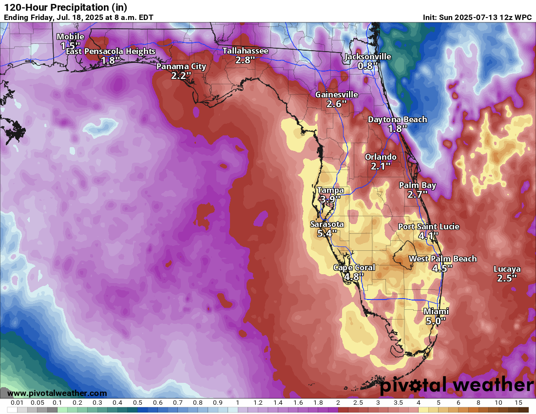
Finally, it should be noted that this system is expected to bring some drought relieving heavy rain across much of the Florida Peninsula beginning as soon as later tonight and Monday and continuing through Thursday. Rainfall totals of 5 to 10 inches are likely across much of Central and South Florida with 2 to 5 inches of rainfall anticipated across north Florida. These rainfall amounts will very likely lead to flash flooding, especially across Central and South Florida where the highest rain amounts will be.
Forecast Rainfall Totals This Week Across Florida:
The next tropical weather discussion will be issued on Monday.