Remnants Of Chantal: The remnants of Chantal are moving across southern and eastern Virginia today and are expected to push off of the Mid-Atlantic coast by tonight. The remnants of Chantal will then move east-northeastward out into the open Atlantic as we get into Tuesday and we will be able to close the books on this storm.
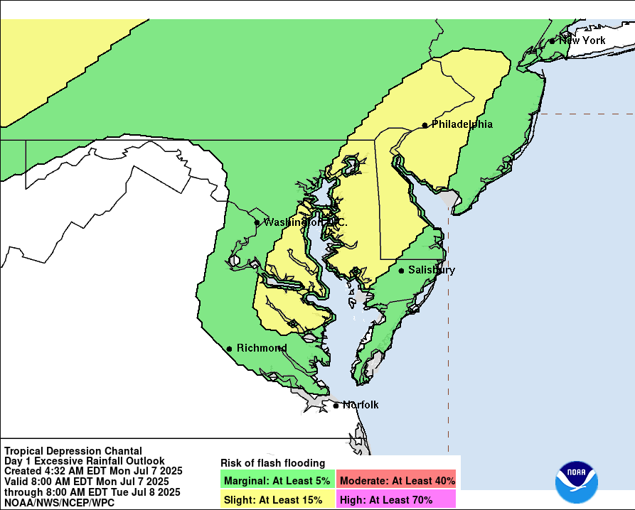
The remnants of Chantal will continue to produce heavy rainfall across the Mid-Atlantic states throughout the rest of today. The highest potential for flooding exists across Maryland and Delaware into southeastern Pennsylvania and southern New Jersey.
Further south across central North Carolina, even though the heavy rainfall associated with Chantal is now done, it did produce some extremely heavy rainfall totals of up to one foot across areas west of Fayetteville and Raleigh-Durham last night. The Haw River near Bynum reached major flood stage shortly before 5 AM ET Monday and then broke the record water level from Hurricane Fran with a peak river level of 22.08 feet.
The Eno River at Durham also appears to have broken its record from Hurricane Fran by about 2 feet with a peak river level of 25.63 feet.
Both rivers are now beginning to recede and will likely fall back to below flood stage by later today or on Tuesday.
This will be the last update on Chantal.
Elsewhere Across The Atlantic, Caribbean & Gulf: There are a couple of areas that I wanted to mention as they did catch my attention.
The First Area That I Wanted To Mention Is a surface trough of low pressure located just north of the Turks and Caicos Islands. This trough of low pressure is producing some shower and thunderstorm activity and there are a few reasons why it caught my attention.
The first reason is that the wind shear values over this trough of low pressure are only between 5 and 15 knots, which is favorable for development.
The second reason is that there is actually some low and mid level spin associated with this system and I do think this is something that should be watched, in case it does try to spin-up into a low pressure system.
While most of the model guidance really doesn’t forecast development of this trough of low pressure, it should be noted that the European ensemble model guidance does forecast a 30 percent chance for tropical development by the time this system reaches near the North Carolina coast later this week into this weekend.
While I’m not expecting any sort of immediate tropical development from the area of showers and thunderstorms north of the Turks and Caicos, it is something that I will be keeping an eye on, just in case. All-in-all though, I think the chances for development look fairly low.
The Second Area I Wanted To Mention Is the possibility that we could see some sort of tropical development over the northern Gulf around the middle and later parts of next week. A very similar weather setup looks to occur as we just saw with Chantal as a frontal boundary stalls out over the northern Gulf and tries to spin up a tropical system near the tail end of the front.
As for the model guidance, the GFS ensemble model guidance does show a few members forecasting some development occurring over the northern Gulf around the middle and later parts of next week.
As for the European ensemble model guidance, there are only two ensemble members that show development in the northern Gulf around the middle part of next week. It should be noted that the European ensemble model guidance is forecast about a 10-15 percent chance for development in the northern Gulf during the second half of next week.
At this point, I think that there is certainly the possibility for tropical development in the northern Gulf during the second half of next week. That said, the chances for it to occur are quite low right now. For now, this is something to just keep an eye on, just in case & is nothing to be worried or concerned about.
The next tropical weather discussion will be issued on Wednesday.