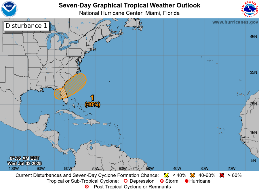
Tropical Development Looks Possible Near The Coasts Of Northeast Florida, Southeast Georgia & Eastern South Carolina This Weekend: The latest weather analysis as of today indicated that there is a weakening cold front pushing southward into the Carolinas and parts of the Deep South. This cold front is expected to continue weakening as it pushes into the area from the northern Gulf eastward to across Florida and into the southwestern North Atlantic as we get into Thursday and Friday. It is quite possible that we could see a tropical depression or a tropical storm spin up from this front this weekend near the coastal parts of northeast Florida, southeast Georgia or eastern South Carolina.
A look at satellite imagery right now indicated that there seems to be two areas of convection to watch. The first area is located over the northeastern Gulf where convection has persisted since yesterday. The wind shear values over this convection are favorable for development, however, any associated spin is disconnected from the convection. The second area of convection looks more frontal and is likely connected to the approaching front. This convection stretches from the northernmost Bahamas northeastward to off of the Carolina coastline. All-in-all, both areas of convection are not expected to develop immediately.
Latest Model Guidance: The model guidance have begun to hone in on the more possible area to watch for development this weekend as they now seem to agree that the area between near the coast of northeast Florida and near the Carolina coastline is the spot to watch.
A majority of the GFS ensemble model guidance members that do show development forecast this system to form near the coasts of northeast Florida, southeast Georgia and eastern South Carolina during this weekend. The ensemble model guidance members then show any system to head northeastward and stay well east of New England during the first half of next week.
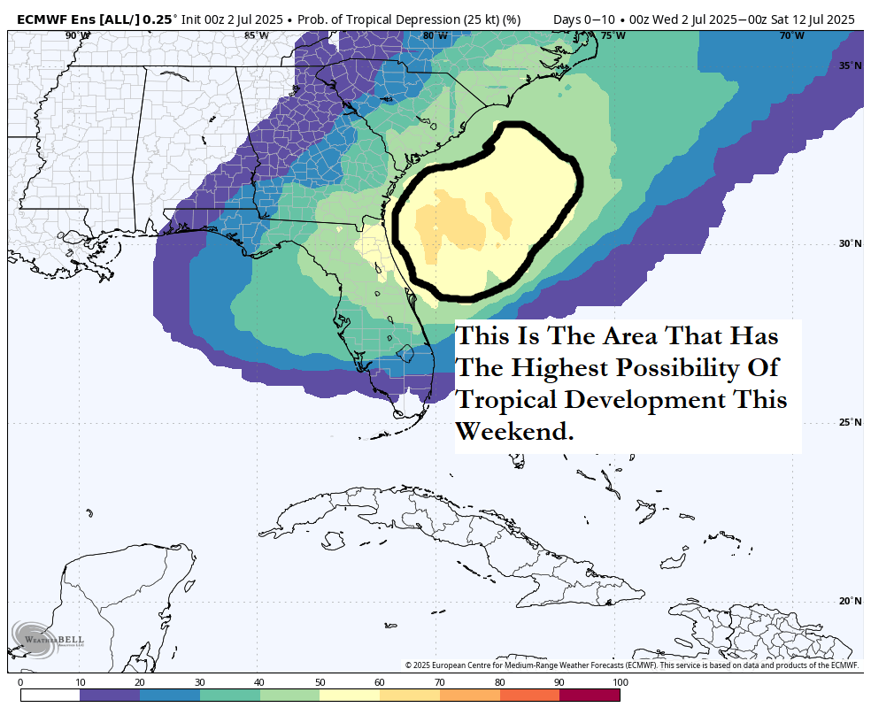
The latest European ensemble model guidance agrees with the GFS ensemble model guidance in that most of its members show development occurring very near coastal parts of northeast Florida, southeast Georgia and eastern South Carolina during this weekend. Most of the ensemble members show any system to head north and northwestward towards the coastal Carolinas by early next week. The European ensemble model guidance also is forecasting up to a 60 percent chance of tropical development near coastal parts of northeast Florida, southeast Georgia and eastern South Carolina during this weekend.
Here Are My Thoughts: Based on all of the data available, I think that the area to keep a close eye on is near coastal parts of northeast Florida, Georgia and South Carolina where the development chances are increasing for this weekend. As I have mentioned in previous discussions, old fronts sitting over the warm waters of the southwestern North Atlantic are ripe for producing spin-up tropical systems and this is exactly what I think will occur this coming weekend.
I think the chance for the development of a tropical depression or a low end tropical storm are at around 65 percent during this weekend near the coasts of northeast Florida, southeast Georgia and eastern South Carolina. Any system would probably then be pulled northward towards the coastal Carolinas during the early part of next week.
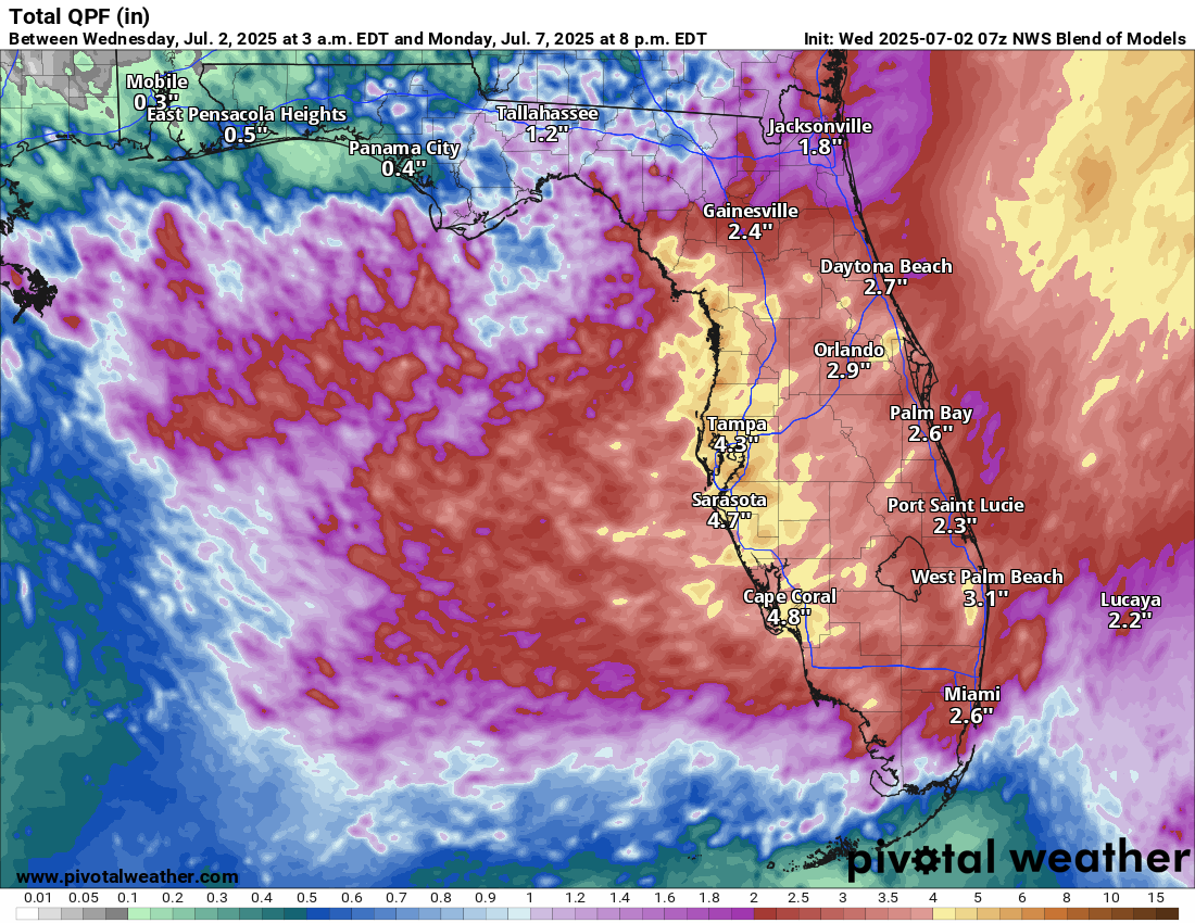
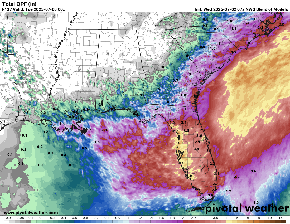
Heavy Rainfall Threat Concentrated Across Parts Of The Florida Peninsula: Heavy rainfall is going to be a threat the next several days, including during the entire Fourth of July weekend, across much of the Florida Peninsula & particularly along the west coast of Florida and along the I-4 corridor from Tampa to Orlando.
The heavy rain threat looks to develop on Thursday in the form of showers and thunderstorms across a large part of the Florida Peninsula with the highest amounts occurring along Florida’s west coast. The heavy rainfall will likely produce local areas of flooding in urban environments and low-lying areas. Street, highway and small stream flooding is also possible.
Turning to the Fourth of July holiday weekend – The combination of tropical moisture, an unstable air mass and forcing from the developing system near the southeastern coast of the US will lead to the threat for heavy rainfall across a large part of the Florida Peninsula. As I already mentioned, the west coast of Florida and areas near the I-4 corridor from Tampa to Orlando will see the heaviest rainfall amounts this weekend. This heavy rainfall will lead to localized areas of flooding with urban areas and low-lying areas most vulnerable.
Forecast Total Rainfall Totals From Thursday To Monday:
The next tropical weather discussion will be issued on Thursday.