Weather analysis today reveals that the area to watch the next few days will be an area from the far eastern Pacific northward into the Bay of Campeche.
Satellite imagery today shows that there is convection occurring across the Bay of Campeche. This convection is being caused by a surface trough of low pressure that will head towards eastern Mexico over the next couple of days.
The system to really keep an eye on is a tropical disturbance that’s located over the far eastern Pacific just south of Central America. Weather analysis seems to indicate that a low pressure system is connected with this area of disturbed weather. The actual low pressure system is located near 9.5 North Latitude, 89.9 West Longitude. The environmental conditions are favorable for additional development and it seems very likely that this disturbed weather will become yet another Eastern Pacific tropical storm over the next couple of days or so. In fact, it is quite possible that this system could become a hurricane before it comes ashore over southern Mexico later this week.
There is uncertainty as to where exactly this disturbance will make landfall later this week and this is important in terms of whether this will be a crossover tropical system or not. Most of the model guidance seems to suggest that there will be no crossover of this system and thus no tropical development will occur in the Bay of Campeche late this week. I suspect that this will actually be the case and because of this, any development in the Bay of Campeche or the southwestern Gulf late this week has a very low chance of occurring (10 percent or less).
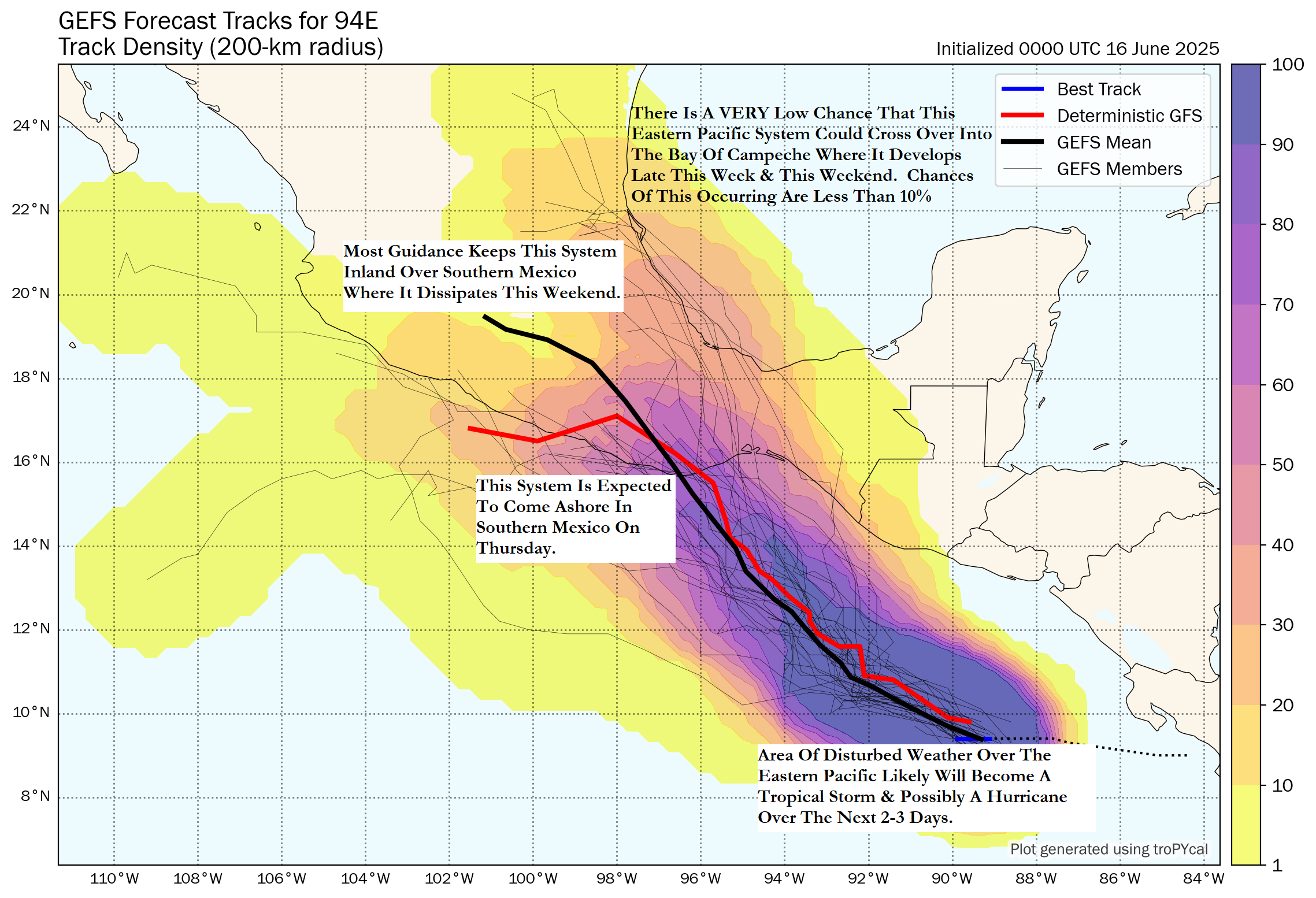
What this eastern Pacific tropical system will do is bring heavy rain and flooding to southern and eastern Mexico starting on Thursday and continuing through Friday and the weekend. Rainfall totals of up to 4 to 8 inches can be expected across southern and eastern Mexico late this week. It is possible that some of this rain could push as far north as far South Texas and the Rio Grande Valley around Friday into this weekend. That said, there is considerable amounts of uncertainty as to whether this rain will even make it as far north as South Texas. It is something to watch either way.
Elsewhere Across The Atlantic, Caribbean & Gulf: Tropical development looks highly unlikely across the rest of the Atlantic Basin throughout this week and probably through this weekend. The overall weather pattern looks unfavorable for any sort of tropical development for at least the next 7-10 days. In fact, none of the model guidance shows any sort of tropical development during the rest of this month and it’s quite possible that we could end up with no named storms in June this year.
The next tropical weather discussion will be issued on Wednesday.