Weather analysis as of this afternoon indicated that all is quiet across the Atlantic, Caribbean and the Gulf. Extremely strong wind shear values continues to affect all of the Atlantic, Caribbean and Gulf & these very strong wind shear values are highly unfavorable for any sort of tropical development.
I did want to mention that there is an area of disturbed weather located over the far eastern Pacific to the south of the coast of southern Mexico. This area of disturbed weather is likely to develop into a tropical depression and probably the first tropical storm of the season in the eastern Pacific by the middle part of this week. It should be noted that this system will travel out into the open waters of the eastern Pacific and not be a threat to any land areas.
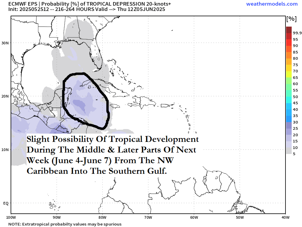
Tropical Development Is A Possibility During The Middle & Later Parts Of Next Week (June 4 To June 7) Over The Western & Northwestern Caribbean Into The Gulf: There is the possibility that tropical mischief could occur in the area from the western Caribbean into the Gulf during the first week of June. I want to explain why I think that this is a very real possibility.
Satellite imagery as of this afternoon indicated a tropical wave now located over the far eastern Tropical Atlantic very near 30 West Longitude. This tropical wave lacks any sort of deep convection, but analysis reveals that there is some low-level spin evident with the tropical wave. For now, this tropical wave probably will not do anything in terms of development for the next several days or so.
It is expected that this tropical wave will move westward throughout this upcoming week through next weekend. This tropical wave should reach the western Caribbean by about early next week (around June 2 or 3) where it may need to be watched for possible tropical development.
The energy and moisture from that tropical wave may combine with a favorable background state for development from a upward motion pulse of the Madden Julian Oscillation once it reaches the western Caribbean early next week. This combination could lead to favorable conditions for tropical development in the western Caribbean next week (June 2-7) & anything that tries to develop could be pushed into the Gulf.
Latest Model Guidance: The model guidance have been gradually trending towards increased chances for tropical development next week.
The GFS model does point to an area of disturbed weather to be located in the western and northwestern Caribbean by next Monday and the disturbed weather to gradually push into the southeastern Gulf and the up the East Coast of the United States by later next week.
The European model indicates the possibility of an area of disturbed weather to be located from the northwestern Caribbean northward into South Florida by the first half of next week (June 2-4). The European model then forecasts this disturbed weather to head northward across the eastern Gulf later next week.
A look at the GFS ensemble model guidance reveals an increase in members showing development across the northwestern Caribbean and the southern Gulf by the middle part of next week. The GFS ensemble members then diverge with some members forecasting a track northward towards the central Gulf Coast by about June 7 with other members forecasting a northeasterly track towards Florida and up the East Coast of the United States. Yet other ensemble members show a track westward towards the Bay of Campeche and the southwestern Gulf.
The European ensemble model guidance does show a few members forecasting development in the northwestern Caribbean into the eastern Gulf by the middle part of next week. Much like the GFS ensemble model, the European ensemble model members diverge in showing where any development might go. Some members show a track towards the central Gulf coast while others show this system remaining in the southern Gulf through late next week before slowly moving northward next weekend (June 7-8).
The European ensemble model guidance also shows a 20-25 percent chance for tropical development in the northwestern Caribbean later next week.
Here Are My Thoughts As Of Late Sunday Afternoon: I do think that the weather pattern over the next one to two weeks is certainly pointing towards tropical mischief to occur in the western Caribbean and the Gulf.
The weather pattern this coming week includes a strong upper level trough of low pressure to push into the eastern United States by late this week and will remain in place through next weekend.
That upper level trough of low pressure is expected to lift out of the eastern United States by the first half of next week, however, a piece of energy may be left behind over the southeastern Gulf and the northwestern Caribbean by the middle part of next week.
This piece of energy could combine with that westward moving tropical wave and the favorable background state of the Madden Julian Oscillation leading to the possibility of northwestern Caribbean tropical development around the middle and later parts of next week. This is something that certainly has my attention and is something that I will be keeping a close eye on.
The next tropical weather discussion will be issued on Wednesday.